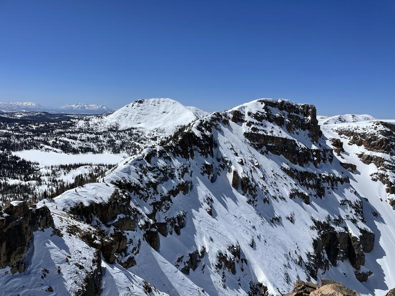
Forecast for the Uintas Area Mountains

Craig Gordon
Issued by Craig Gordon for
Saturday, April 9, 2022
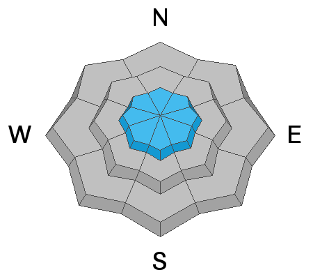
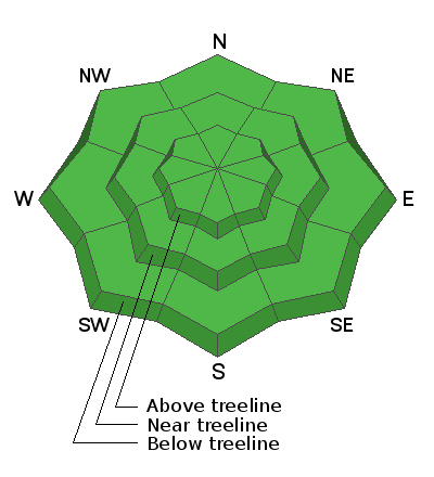
If you're looking for LOW avalanche danger you came to the right place. Green Light conditions blanket the danger rose, suggesting human triggered avalanches are unlikely on all aspects and elevations. Sure, most terrain is good to go... but if you're stepping into a big, committing line take a second or two and think about the consequences of triggering even a small avalanche that could knock you off your feet and instantly throw a curve ball at your day.

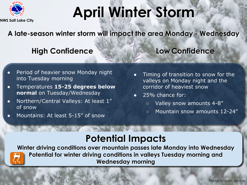
A robust storm is on tap for next week, changing the landscape and the avalanche hazard. Of course, we've got yer back and will keep you posted as the storm materializes.
Low
Moderate
Considerable
High
Extreme
Learn how to read the forecast here
Weather and Snow
NOWCAST-
Ahead of a mostly dry cool front slated to slide into the region later today, high clouds drift into our mountains keeping overnight low temperatures rather balmy and currently reading in the upper 30's across the board. Southwest winds began ramping into the 20's and 30's with a few gusts in the 40's before the turn of the new day and continue in that spirit early this morning. Riding and turning conditions are hit or miss.
FORECAST-
Expect a warm and windy morning with increasing clouds and a slight chance for a snow flake or two. Southwest winds are gonna be irritating, especially near the ridges where they blow in the 40's and 50's. Winds shift to the west and northwest later today and decrease, with overnight lows crashing into the teens.
FUTURECAST-
Partly cloudy skies and crisp temperatures are on tap for Sunday and then a good looking storm materializes to kick off the work week. The graphic above delivers the timing for the next storm.
Andy and I grabbed the Are You Beeping sign and Beacon Park from Nobletts yesterday and found a lot of pavement between the Road Closed sign and contiguous strips of ridable snow.
Trip reports and snowpack observations are found HERE.

Looking for real-time temps, snow, or wind? Click HERE and then on the "western Uinta" tab for western Uinta specific, weather station network.
Recent Avalanches
No recent avalanche activity to report.
An archive of recent slides is found HERE.

Your input is vital and we're interested in what you're seeing. Please contribute to this great community resource and go here to fill out an observation.
Ad
Avalanche Problem #1
Wind Drifted Snow
Type
Location
Likelihood
Size
Description
With a stable snowpack, a go anywhere base, and green light avy conditions, you'll probably wanna stretch your wings today and get into big terrain... and you should! But, before blindly sending it, know that the mid week storm delivered 6" of fresh snow and a lot of wind and there may still be a rogue wind drift or two that could react to our additional weight. All while most of the mid week slabs feel pretty welded in place, I always think about the consequences of triggering even a small slide that can knock me off my skis, board, or sled.
Additional Information
Your observations are important, so please let me know what you're seeing... click HERE and contribute to this amazing community based program
General Announcements
The information in this forecast expires 24 hours after the day and time posted, but will be updated by 07:00 Sunday, April 10th.
Before it gets too crazy, now is the time to book an avalanche awareness presentation for your group, club, or posse. You can reach me directly at 801-231-2170 or [email protected]
This forecast is from the U.S.D.A. Forest Service, which is solely responsible for its content. This forecast describes general avalanche conditions and local variations always occur.