UDOT PLANNED AVALANCHE CLOSURES!!

Forecast for the Uintas Area Mountains

Craig Gordon
Issued by Craig Gordon for
Wednesday, April 6, 2022
Strong winds from nearly every quadrant of the compass whipped up fresh drifts near and above treeline where MODERATE avalanche danger is found. Human triggered avalanches big enough to boss you around are POSSIBLE on steep, wind drifted slopes. But fret not... because when you lose the wind, you lose the problem, particularly on mid and low elevation wind sheltered slopes where you'll encounter generally LOW avalanche danger and that means human triggered avalanches are UNLIKELY.
Low
Moderate
Considerable
High
Extreme
Learn how to read the forecast here
Weather and Snow
NOWCAST-
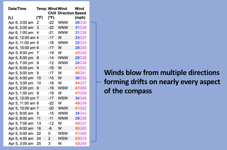
Yesterday's North Slope-centric storm stacked up 6"-8" of low density snow, while the south half of the range collected half that amount. Cold air spilled into the region overnight, skies cleared, and temperatures dropped like a rock, crashing into the teens and single digits. Northwest winds blow 20-30 mph near the high peaks creating a windchill that registers to -22 degrees. Riding and turning conditions could be somewhat rugged, but I bet with a little hunting, you can find soft, settled snow on mid and low elevation, wind sheltered slopes.
FORECAST-
Look for mostly sunny skies with temperatures climbing into the low 30's. Northwesterly winds are gonna be obnoxious, blowing in the 30's near the high peaks, but decrease as the day wares on. Overnight lows dip into the teens.
FUTURECAST-
Clear skies with warming temperatures and light winds round out the work week. A more stormy pattern is expected to develop by late in the weekend, persisting through much of the upcoming week... I'll keep ya updated as things materialize.
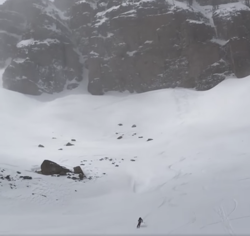
Yesterday's winds nuked, blowing from nearly every direction, torching a lot of big terrain throughout the range. I asked the owner of Inspired Summit Adventures, the ever intrepid Shaun Raskin... "did the snow get torched?" And she says... "like a Portobello in a Traeger". Shaun is seen in the image above, toughing it out and turning the rotisserie yesterday in Gods Living Room, a high alpine jewel near Bald Mountain.
Trip reports and snowpack observations are found HERE.

Looking for real-time temps, snow, or wind? Click HERE and then on the "western Uinta" tab for western Uinta specific, weather station network.
Recent Avalanches
No significant avalanche activity to report.
An archive of recent slides is found HERE.

Your input is vital and we're interested in what you're seeing. Please contribute to this great community resource and go here to fill out an observation.
Ad
Avalanche Problem #1
Wind Drifted Snow
Type
Location
Likelihood
Size
Description
Above is a 24 hour data dump reflecting strong ridgetop winds from Windy Peak (10,662')
Winds have been all over the compass and as such I bet you can find rogue wind drifts formed in some unusual places. While mostly found on the leeward side of upper elevation ridges, be on the lookout for fresh drifts that also formed around terrain features like chutes and gullies. Easy to detect by their fat, rounded appearance, they're easy to avoid by losing elevation and seeking out wind sheltered mid and low elevation terrain.
Additional Information
Your observations are important, so please let me know what you're seeing... click HERE and contribute to this amazing community based program
General Announcements
The information in this forecast expires 24 hours after the day and time posted, but will be updated by 07:00 Thursday, April 7th.
Before it gets too crazy, now is the time to book an avalanche awareness presentation for your group, club, or posse. You can reach me directly at 801-231-2170 or [email protected]
This forecast is from the U.S.D.A. Forest Service, which is solely responsible for its content. This forecast describes general avalanche conditions and local variations always occur.