Forecast for the Uintas Area Mountains

Craig Gordon
Issued by Craig Gordon for
Tuesday, April 5, 2022
Strong winds whip up fresh drifts near and above treeline where MODERATE avalanche danger materialized overnight. Human triggered avalanches are POSSIBLE on steep, wind drifted slopes, especially those facing the north half of the compass. But fret not... because when you lose the wind, you lose the problem, particularly on mid and low elevation wind sheltered slopes where you'll encounter generally LOW avalanche danger and that means human triggered avalanches are UNLIKELY.
Low
Moderate
Considerable
High
Extreme
Learn how to read the forecast here
Special Announcements
I'd like to thank our incredible community for your support of the 2022 Spring Campaign. We raised $75,000 in two weeks to help grow our avalanche forecasting program. Thank You!
Weather and Snow
NOWCAST-
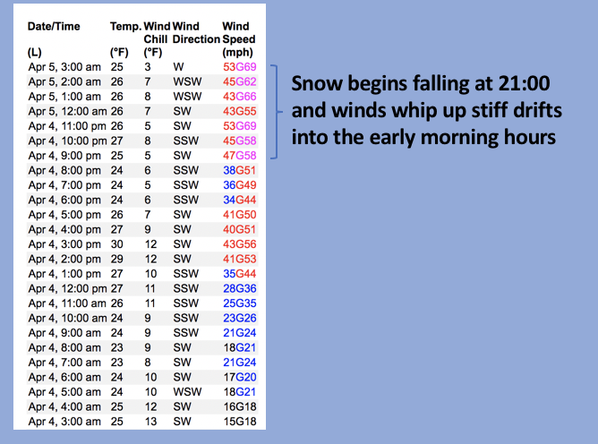
A band of thick clouds brought a fully electric show to the mountains overnight delivering a few inches of snow along with west-southwest winds cranking in the 50's and 60's along the high ridges. Close to the traillheads temperatures register in the low 30's whilst near the high peaks it's slightly cooler and in the mid 20's. In either case... it's a rugged start to the day. Best to get your chores done today, allow some snow to stack up, and get after it tomorrow when the mountains offer a less agro mosh pit and more user friendly setlist.
FORECAST-
Cloudy skies produce a good shot of snow, especially early this morning when we see an additional 2"-4" of snow quickly stack up right around sunrise. Winds shift to the west and northwest and remain obnoxious, blowing in the 40's and 50's as the bulk of an upstream cold front slides through the region. Winds taper off as the day wares on, but temperatures don't vary much from where we're at this morning and dip into the teens under clearing skies overnight.
FUTURECAST-
Clear skies with warming temperatures and light winds are on tap for midweek with the work week rounding out in that same spirit. But wait... there's more! A good looking shot of snow for early next week is worth keeping an eye on and scheduling your work week around... I'll keep ya updated as things materialize.
Looking down the barrel of Notch Mountain... recently Michael J had a blast on a big slope, harvesting a bounty of corn and has a great trip report found HERE.
Addional trip reports and snowpack observations are found HERE.

Looking for real-time temps, snow, or wind? Click HERE and then on the "western Uinta" tab for western Uinta specific, weather station network.
Recent Avalanches
No significant avalanche activity to report.
An archive of recent slides is found HERE.

Your input is vital and we're interested in what you're seeing. Please contribute to this great community resource and go here to fill out an observation.
Ad
Avalanche Problem #1
Wind Drifted Snow
Type
Location
Likelihood
Size
Description
Above is a 24 hour data dump reflecting strong ridgetop winds from Windy Peak (10,662')
Winds are always the great equalizer for the western Uinta's and last nights fresh snow now provides some new material for winds to work with. In fact, I think this combo created stiff drifts overnight and they'll be reactive to our additional weight. Found mostly on the leeward side of upper elevation ridges, be on the lookout for fresh drifts that also formed around terrain features like chutes and gullies. Easy to detect by their fat, rounded appearance, they're easy to avoid by losing elevation and seeking out wind sheltered mid and low elevation terrain.
Additional Information
Your observations are important, so please let me know what you're seeing... click HERE and contribute to this amazing community based program
General Announcements
The information in this forecast expires 24 hours after the day and time posted, but will be updated by 07:00 Wednesday, April 6th.
Before it gets too crazy, now is the time to book an avalanche awareness presentation for your group, club, or posse. You can reach me directly at 801-231-2170 or [email protected]
This forecast is from the U.S.D.A. Forest Service, which is solely responsible for its content. This forecast describes general avalanche conditions and local variations always occur.