Forecast for the Uintas Area Mountains

Mark Staples
Issued by Mark Staples for
Wednesday, April 12, 2023
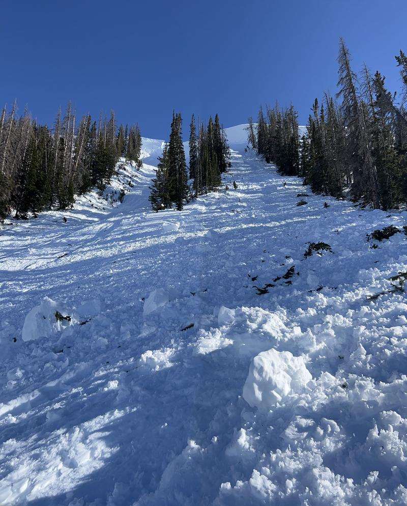
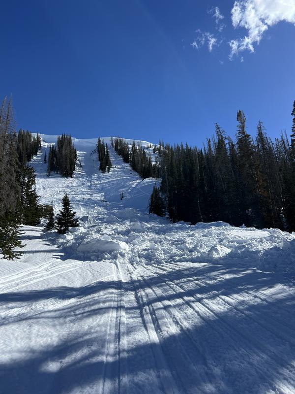
Today the avalanche danger is HIGH on all aspects near and above treeline where wet avalanches are likely.
Below treeline where the snowpack is further along in its transition to a spring snowpack, natural wet avalanches are possible and the danger is CONSIDERABLE.
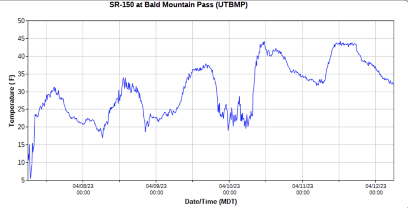
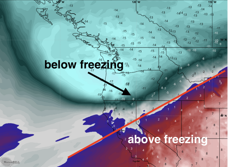
These dangerous avalanche conditions are the result of the rapid shift from cold winter conditions to hot spring weather. Liquid water will be running through the snowpack today as very warm temperatures melt and destabilize the snow. Avoid being on or under all avalanche terrain today.
Low
Moderate
Considerable
High
Extreme
Learn how to read the forecast here
Avalanche Warning
The avalanche danger for the warning area will rise to HIGH with daytime heating.
In effect from 6 am MST Sunday April 9 to 6 am MST Thursday April 13.
For the mountains and foothills of Northern Utah, including the Wasatch Range...Bear River Range...Wellsville Range...Oquirrh Mountains...Stansbury Range...Cache Valley...Ogden Valley...Skyline...Uinta Mountains
Warm temperatures and the intense sun will create widespread areas of unstable wet snow. Natural and human-triggered cornice falls and wet avalanches are certain. People should avoid being in avalanche terrain (off of and out from under slopes steeper than 30°) and stay clear of avalanche runouts on all aspects and elevations.
Special Announcements
The final UAC report for the Upper Weber Canyon avalanche accident on March 9 has been published and is available HERE. The UAC would like to thank Park City Powder Cats for sharing information about the timeline of the accident and allowing UAC staff access to the avalanche after the incident.
Weather and Snow
It has been over 48 hours without below freezing air temperatures (see graph below from Bald Mountain Pass), and partial clouds overnight would have limited any cooling of the snow to the night sky.
This morning temperatures are mostly in the low to mid 40s F following high temperatures yesterday approaching 60 degrees. Strong winds at upper elevations continue blowing from the south at 35 mph with gusts up to 57 mph.
Today will have increasing clouds as a cold front approaches. Temperatures will quickly climb into the 50s F and strong winds from the south will continue. The cold front doesn't arrive until tonight (scroll to the the bottom to see a screen shot of air temperatures at 10,000 ft) when it should bring below freezing temperatures. Some snow will fall tomorrow but maybe only an inch or two.
Temperature graph from Bald Mountain Pass on the Mirror Lake Highway at 10,727 ft.
Recent Avalanches
A group in Super Bowl spotted a recent avalanche triggered by a falling cornice on a north facing slope yesterday.
Photo - H. Penrose
Ad
Avalanche Problem #1
Wet Snow
Type
Location
Likelihood
Size
Description
With above freezing temperatures for over 48 hours, a lot of melt water has likely been moving through the snowpack destabilizing it. Stability will improve after the water has established drainage channels in the snowpack and cooler temperatures return. For now, I don't know exactly where the snowpack is with this process and conditions remain dangerous during this transitional phase (from winter snowpack to spring snowpack).

Many wet loose avalanches are likely today. Wet slab avalanches have occurred throughout the Wasatch Range which is a good warning that they are possible in the Uinta Range as well.
Avalanche Problem #2
Cornice
Type
Location
Likelihood
Size
Description
Large cornices exist throughout the Uintas. With continued heat, many should break today if they haven't already. Avoid being underneath conices which create their own hazard as well as possibly triggering an avalanche as one group observed yesterday in Super Bowl.
Photo - H. Penrose
Additional Information
Below is a screenshot from the ECMWF weather model of air temperatures at approximately 10,000 ft. Notice Utah has been under very warm air which will remain in place Wednesday. Cold air will move over Utah late Wednesday night.
General Announcements
This forecast is from the U.S.D.A. Forest Service, which is solely responsible for its content. This forecast describes general avalanche conditions and local variations always occur.