Donate to the 2024 Spring Campaign to help rebuild the UAC website.

Forecast for the Uintas Area Mountains

Craig Gordon
Issued by Craig Gordon for
Friday, April 12, 2019
Dry snow avalanches-
In upper elevation terrain, especially in the wind zone at and above treeline, you'll find pockets of MODERATE avalanche danger. Human triggered avalanches are POSSIBLE on steep, leeward slopes, especially those facing the south half of the compass. Lose a little elevation and you lose the problem.
Wet snow avalanches-
If the sun comes out for any length of time, the danger of wet avalanches may quickly rise to MODERATE on steep, sun-exposed slopes.
Low
Moderate
Considerable
High
Extreme
Learn how to read the forecast here
Special Announcements
Thank you to everyone who supported our spring fundraiser. We reach and exceeded our goals. The UAC could not exist without your support.
Sunday, April 14th will be the last of our regularly scheduled Uinta forecasts.
Weather and Snow
A moist, northwest flows keeps unsettled weather going throughout the day. As a matter of fact, a band of snow showers is developing as I type, and should slide into the region before dawn. Currently, under mostly cloudy skies temperatures remain winter-like, hovering in the teens. Along the high ridges northerly winds are light, blowing less than 20 mph. On a phat, white, go-anywhere base, riding and turning conditions remain quite good, especially on mid elevation wind sheltered slopes.
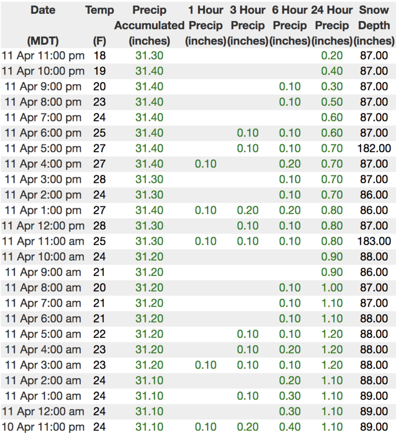
No updated mesowest data... note the 11:00 PM time stamp on hourly snow and water totals from Chalk Creek (9,169')
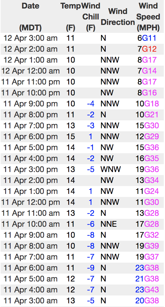
A different network Lofty Lake Peak (11,186') offers real-time info.
To view more regional weather stations click here.
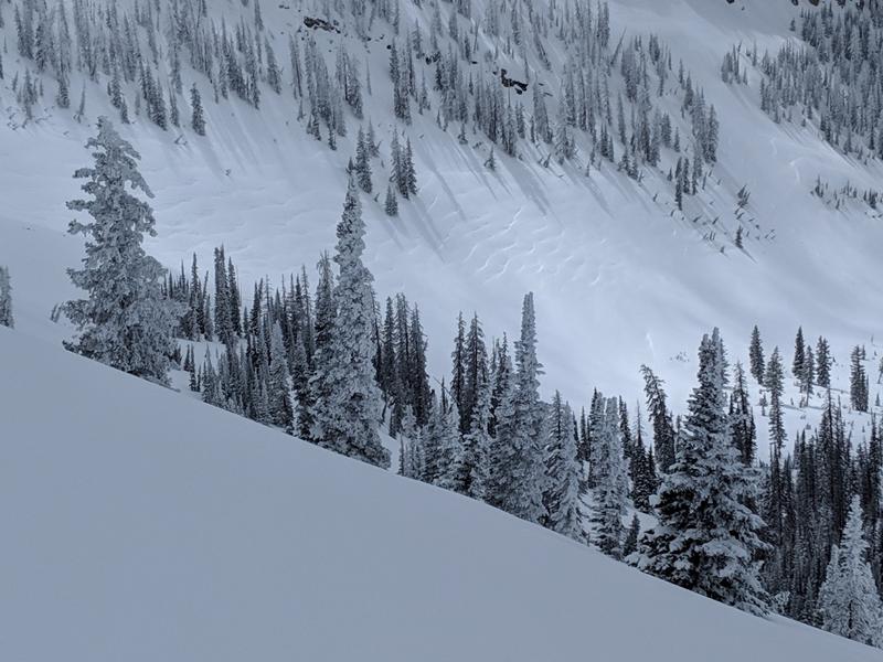
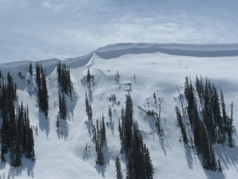
Northerly winds blew upslope, essentially throwing a cargo net over large swaths of open terrain like in the image above.
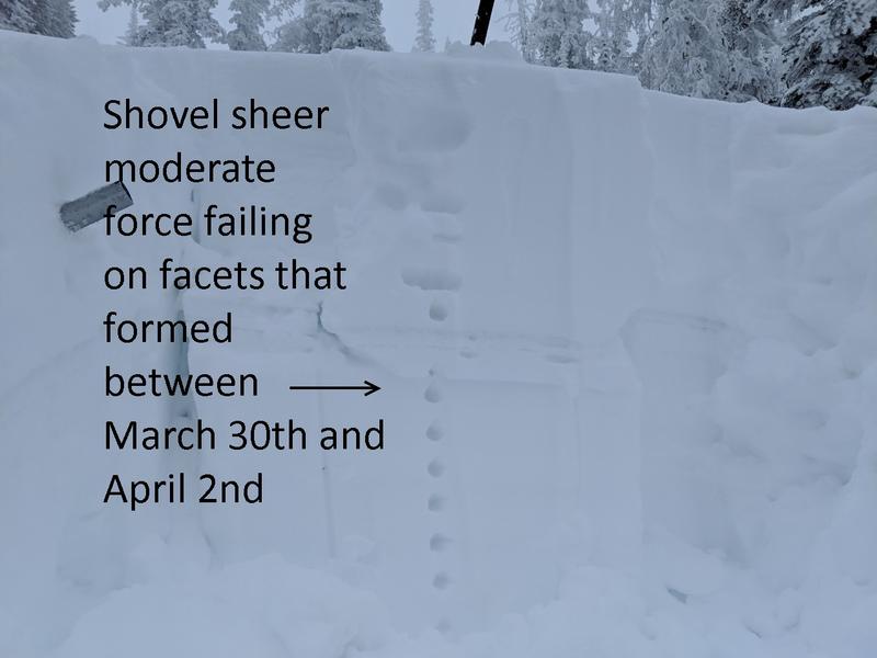
While not particularly widespread, Michael J notes.... "My stability tests showed a weak layer about 4 inches below the melt-freeze crust but my ECT failed to propagate. On my way out I was kicking some new snow off a cornice and was caught by surprise when the old snow failed behind my feet." More on Micheal's travels in Weber Canyon are found here.
Recent Avalanches
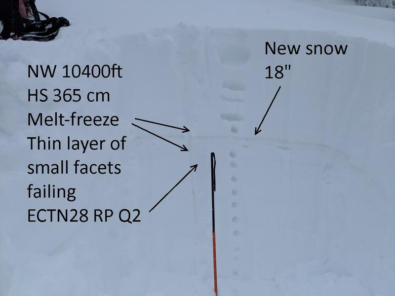
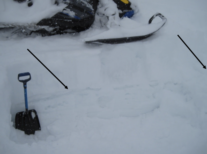
No significant avalanche activity to report from yesterday, but visibility was hit or miss. The image above illustrates the new snow/old snow layering Ted found on the North Slope in wind sheltered terrain.
Recent trip reports and avy activity found HERE.
Ad
Avalanche Problem #1
Wind Drifted Snow
Type
Location
Likelihood
Size
Description
Post-frontal, upper elevation, northerly winds cranked late Wednesday and had no problem forming fresh drifts on steep, leeward slopes. Fortunately, winds started relaxing early yesterday morning, but there may still be a few lingering drifts that'll react to our additional weight. Found mostly on upper elevation leeward slopes facing the south half of the compass, also be on the lookout for a rogue drift or two cross-loaded in and around terrain features like chutes or gully walls. The good news is... this avalanche problem is easily avoidable by simply losing a little elevation and steering yourself towards wind sheltered terrain, where you'll find soft creamy snow and a more predictable avalanche hazard.
And remember-
It's triple overhead in some places.... recent winds coupled with fresh snow will add yet another layer to our already ginormous, ridgeline cornice formations. Breaking further back than you might expect, you'll definitely wanna give these large, unpredictable pieces of snow the respect they deserve and not ruin someones day below by inadvertently knocking a boxcar size piece of snow down on them.
Avalanche Problem #2
Wet Snow
Type
Location
Likelihood
Size
Description
If the sun comes out for any length of time, expect the danger of wet avalanches to rapidly rise. Be aware that once triggered, even a small slide can fan out, entraining more snow as it slowly descends a steep slope, eventually conspiring against us to pile up cement-like, bone snapping avalanche debris. Putting it all together, you'll want to think about your travel plans and remember to avoid terrain traps like gullies and road cuts where avalanche debris can stack up very deeply.
Here's a great viddy describing a myriad of spring snow avalanche conditions.
Additional Information
Look for mostly cloudy skies and scattered snow showers throughout the day, though accumulations will be negligible. High temperatures climb in the low 30's and overnight lows dip into the teens. Winds remain light and northerly. A lull in the weather is expected tonight through Saturday night and then southerly winds ramp up Sunday ahead of a storm system that brings another round of snow later Sunday through the early portion of the week.
General Announcements
The information in this advisory expires 24 hours after the date and time posted, but will be updated by 7:00 AM Saturday April 13th, 2019.
If you're getting out and about, please let me know what you're seeing especially if you see or trigger and avalanche. I can be reached at [email protected] or 801-231-2170
It's also a good time to set up one of our very popular avalanche awareness classes. Reach out to me and I'll make it happen.
This information does not apply to developed ski areas or highways where avalanche control is normally done. This advisory is from the U.S.D.A. Forest Service, which is solely responsible for its content. This advisory describes general avalanche conditions and local variations always occur.