Forecast for the Uintas Area Mountains

Craig Gordon
Issued by Craig Gordon for
Tuesday, March 7, 2023
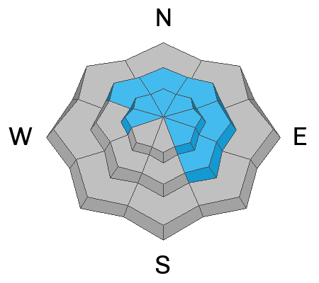
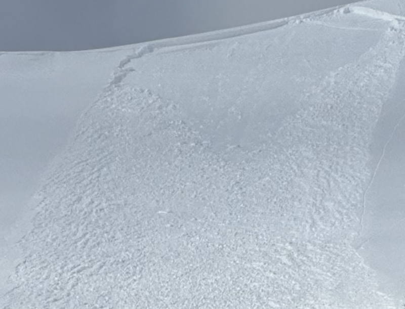
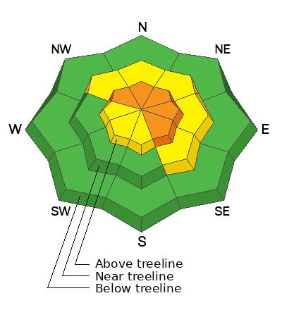
CONSIDERABLE avalanche danger exists on steep, leeward slopes in the wind zone at and above treeline. While not widespread, human triggered avalanches are LIKELY, especially in wind drifted terrain facing the north half of the compass, and particularly on slopes with an easterly component to its aspect. Lose the wind and you'll find more predictable, MODERATE avalanche danger with human triggered, storm snow avalanches POSSIBLE on sustained steep slopes. In either case, once triggered, several storms worth of snow can boss you around and throw a curve ball at your day.
Your exit strategy for LOW avalanche danger is found on mid and low elevation terrain, particularly terrain facing the south half of the compass where human triggered avalanches are UNLIKELY.

Low
Moderate
Considerable
High
Extreme
Learn how to read the forecast here
Special Announcements
To help you safely enjoy the backcountry, the UAC team is constantly evaluating and implementing new programs and technologies. Donate to the Spring Campaign to help our team implement innovative tools and better provide you
Weather and Snow
Nowcast- With mostly cloudy skies overhead, a full, Worm Moon, casts muted light on our mountains this morning as light snow showers deliver a trace of new snow. Westerly winds blow in the low 20's and temperatures, just beginning the graveyard shift, register in the teens and single digits. On a go-anywhere base and with over four feet of storm snow stacking up in the past week, riding and turning conditions are all-time.
Forecast- Light snow showers develop this morning, though accumulations are minor, maybe just an additional inch or three. Winds remain relatively well behaved for a good portion of the day, but switch to the southwest later today and gust into the 40's and 50's right around sunset. High temperatures climb into the mid 20's and overnight lows dip into the teens.
Futurecast- Another weak brush-by tonight into Wednesday delivers a couple inches of additional snow. Look for a break on Thursday with a pattern shift Friday as a warm, moist, atmospheric river has its sights set to round out the work week.
Our good friends at the NWS in the City of Salt, lay out the timeline for early Tuesday precip in the graphic above.
Micheal J, still reeling from the intoxicating stoke of his new snowbike, was in the Hoyt environs yesterday, and reports a colossal snowpack and excellent riding conditions.
Detailed trip reports and recent obs are found HERE.
Recent Avalanches
A quiet day on the eastern front yesterday, but plenty of avy activity to peruse if ya wanna geek out... click HERE to track this years slide activity throughout the range.
Ad
Avalanche Problem #1
Wind Drifted Snow
Type
Location
Likelihood
Size
Description
Becoming a bit more stubborn, human triggered wind drifts like the one pictured above from Sunday, are the type of avalanche dragon you'll encounter today, on steep, leeward slopes.
Most of our recent storm snow instabilities have settled out nicely in the past few days and are becoming comfortable in their own skin. And that makes sense, because snow is a lot like people and it gets cranky when it goes through a rapid change. However, we have several layers of storm snow that stacked up over the weekend and while they may be harder to initiate, once triggered, today's avalanches will pack a powerful punch. Steep wind drifted slopes facing the north half of the compass is bulls-eye terrain and today's avalanches will break deeper and wider than you might expect... so avoidance is the key to riding safely today. If your objective is tagging sustained steep terrain, consider the consequences of triggering a slide and have an exit strategy in place. Better yet, tweak small test slopes like road banks with characteristics similar to what you wanna ride and see how they're reacting to your additional weight, before blindly center punching a big, committing line.

Additional Information
Sure the riding is gonna be epic today... but ya shoulda been here Sunday.
Weather stations-
And... rime events from January's atmospheric rivers severely crippled the Uinta weather station network. I'm working to get it back up and running, but a few stations are found HERE (click weather stations, and then on the Western Uinta tab)
Observations-
Your observations are important, so please let me know what you're seeing... click HERE and contribute to this amazing community-based program
General Announcements
Issued at 03:07 on Tuesday March 7th this forecast expires 24 hours after the date and time posted, but will be updated by 07:00 Wednesday March 8th 2023.
Before it gets too crazy, now is the time to book an avalanche awareness presentation for your group, club, or posse. You can reach Craig directly at 801-231-2170 or [email protected].

This forecast is from the U.S.D.A. Forest Service, which is solely responsible for its content. This forecast describes general avalanche conditions and local variations always occur.