Forecast for the Uintas Area Mountains

Craig Gordon
Issued by Craig Gordon for
Monday, March 6, 2023
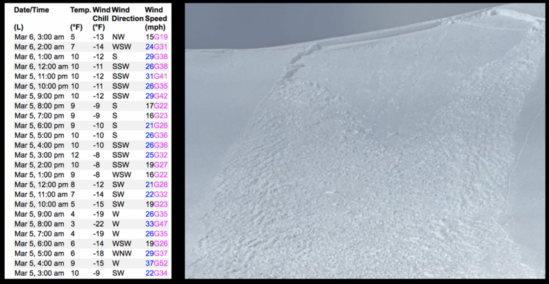
Additional snow and wind maintains elevated avy danger across the range -
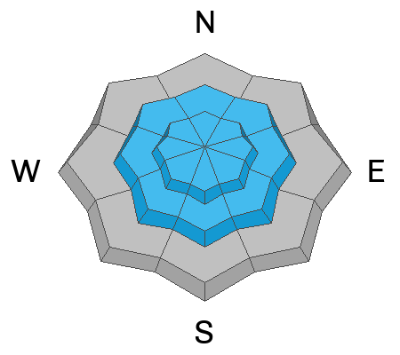
HIGH avalanche danger exists on steep, leeward slopes in the wind zone at and above treeline. Both human triggered and natural avalanches are VERY LIKELY, especially in wind drifted terrain facing the north half of the compass, and particularly on slopes with an easterly component to its aspect. Recent winds penetrated mid elevation terrain where you'll find CONSIDERABLE avalanche danger. Both old and newer wind drifts will react to our additional weight and human triggered avalanches are LIKELY. Lose the wind and you'll find more predictable, MODERATE avalanche danger with human triggered, storm snow avalanches POSSIBLE on sustained steep slopes.
Your exit strategy for LOW avalanche danger is found on low elevation terrain facing the south half of the compass where human triggered avalanches are UNLIKELY.
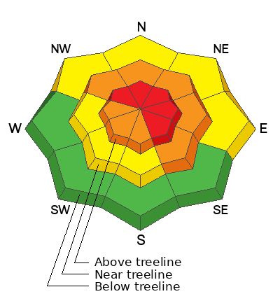
Low
Moderate
Considerable
High
Extreme
Learn how to read the forecast here
Special Announcements
To help you safely enjoy the backcountry, the UAC team is constantly evaluating and implementing new programs and technologies. Donate to the Spring Campaign to help our team implement innovative tools and better provide you
Weather and Snow
Nowcast- Yesterday's storm hit the range like a cross-fire hurricane, quickly stacking up a remarkable 20" of snow with nearly 1.5" H2O. This morning isn't shaping up quite as robust. Under mostly cloudy skies, light snow falls as a storm system dives to the south of our zone early this morning, delivering a glancing blowing with just a couple inches of snow. West and southwest winds aren't taking a detour and haven't taken a break for days, blowing steadily in the 20's and 30's along the high ridges. Temperatures dipped into the single digits and low teens overnight and hold steady this morning. On a go-anywhere base and with over four feet of storm snow stacking up in the past week, riding and turning conditions are all-time.
Forecast- On again, off again snow showers linger over the region, though accumulations are minor, maybe just an additional inch or three. Winds shift to the west-northwest and decrease as the day wares on. High temperatures climb into the mid 20's and overnight lows dip into the single digits.
Futurecast- A slight break for Tuesday with a weak brush-by slated for midweek. A more organized system has its sights set on a weekend visit.
Yup... ya shoulda been here yesterday.
Detailed trip reports and recent obs are found HERE.
Recent Avalanches
It didn't take long yesterday for a little bit of mid morning sun and some heating to instantly bring steep cut banks to life. I found tender storm slabs in Weber Canyon and Joey saw the same avalanche dragon near Soapstone.
Plenty of avy activity to peruse if ya wanna geek out... click HERE to track this years slide activity throughout the range.
Ad
Avalanche Problem #1
Wind Drifted Snow
Type
Location
Likelihood
Size
Description
Above is a 24 hour data dump from Windy Peak and a freshly triggered wind drift, illustrating a cause and effect. In other words... a recently wind loaded slope reactive to our additional weight
Today's fresh wind drifts aren't gonna be quite as reactive as yesterday's hyper-sensitive slabs and that'll make things a bit more tricky. But remember... we now have several layers of storm snow along with both old and freshly formed wind drifted snow. That combo helps connect the dots and once triggered, today's avalanches will pack a powerful punch. Steep wind drifted slopes facing the north half of the compass is bulls-eye terrain to our additional weight and today's avalanches will break deeper and wider than you might expect... so avoidance is the key to riding safely today. Look for and avoid fat, rounded pieces of snow, especially if they sound of feel hollow like a drum. Give this avalanche dragon the respect it deserves and be ready to pump the brakes on objectives if you're seeing shooting cracks out in front your your skis, board, or sled.

Avalanche Problem #2
New Snow
Type
Location
Likelihood
Size
Description
Yesterday's snow took on heat, especially at lower elevations where it has a baked in, shrink-wrapped texture. And while most of our recent storm snow instabilities are settled out and manageable is size and depth, remember, even a small slide can catch you off guard and knock you off your feet, especially in sustained, steep terrain.
Additional Information
Weather stations-
And... rime events have severely crippled the Uinta weather station network. I'm working to get it back up and running, but a few stations are found HERE (click weather stations, and then on the Western Uinta tab)
Observations-
Your observations are important, so please let me know what you're seeing... click HERE and contribute to this amazing community-based program
General Announcements
Issued at 03:17 on Monday March 6th this forecast expires 24 hours after the date and time posted, but will be updated by 07:00 Tuesday March 7th 2023.
Before it gets too crazy, now is the time to book an avalanche awareness presentation for your group, club, or posse. You can reach Craig directly at 801-231-2170 or [email protected].

This forecast is from the U.S.D.A. Forest Service, which is solely responsible for its content. This forecast describes general avalanche conditions and local variations always occur.