UDOT PLANNED AVALANCHE CLOSURES!!

Forecast for the Uintas Area Mountains

Craig Gordon
Issued by Craig Gordon for
Sunday, March 5, 2023
Strong winds and heavy snowfall deliver a one-two punch which changes the avy danger overnight-
HIGH avalanche danger exists on steep, leeward slopes in the wind zone at and above treeline. Both human triggered and natural avalanches are VERY LIKELY, especially in wind drifted terrain facing the north half of the compass, and particularly slopes with an easterly component to its aspect. Winds penetrated mid elevation terrain where you'll find CONSIDERABLE avalanche danger. Fresh wind drifts will react to our additional weight and human triggered avalanches are LIKELY. Lose the wind and you'll find more predictable, MODERATE avalanche danger with human triggered, storm snow avalanches POSSIBLE on sustained steep slopes.

Low
Moderate
Considerable
High
Extreme
Learn how to read the forecast here
Special Announcements
To help you safely enjoy the backcountry, the UAC team is constantly evaluating and implementing new programs and technologies. Donate to the Spring Campaign to help our team implement innovative tools and better provide you
Weather and Snow
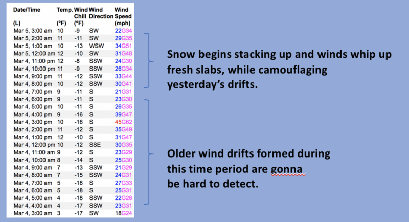
Nowcast- March madness is off to a robust start, ushering in a full court three pointer as a band of heavy snow, strong winds, and yes... even Thunder Snow slams into our mountains. The cold front is making it's way through the eastern front and snow quickly stacks up as I type this update (truth be known... I'm a better talker, than typer :) In either case, the numbers are in and 12" of snow with about .90" H2O evenly blankets the North Slope to Currant Creek. About half that amount is found near Daniels and Strawberry. Temperatures are holding steady in the teens and low 20's, while southwest winds blow in the 30's along the high ridges. On a go-anywhere base and with over three feet of storm snow stacking up in the past seven days, riding and turning conditions are all-time.
Forecast- Snow continues piling up this morning with an additional 2"-4" expected before the storm winds down and we see partly cloudy skies midday. Winds switch to the west and bump into the 40's, while temperatures fall throughout the day.
Futurecast- After a short-lived break, another storm is hot on the heels of today's system. Snow redevelops for late in the day, gets its groove on overnight and we can expect an additional foot of snow for Monday morning. An active pattern kicks off the work week with storminess nearly everyday.
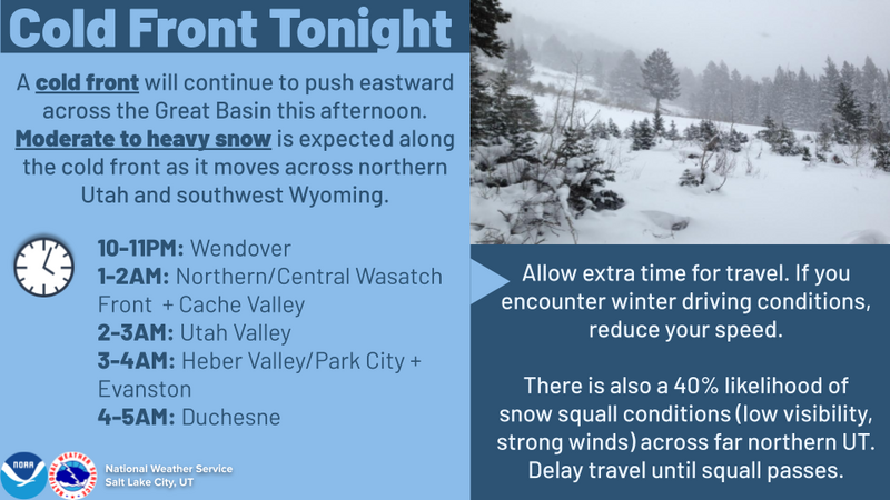
The graphic above lays out the timeline for our next series of weather systems.
Detailed trip reports and recent obs are found HERE.
Recent Avalanches
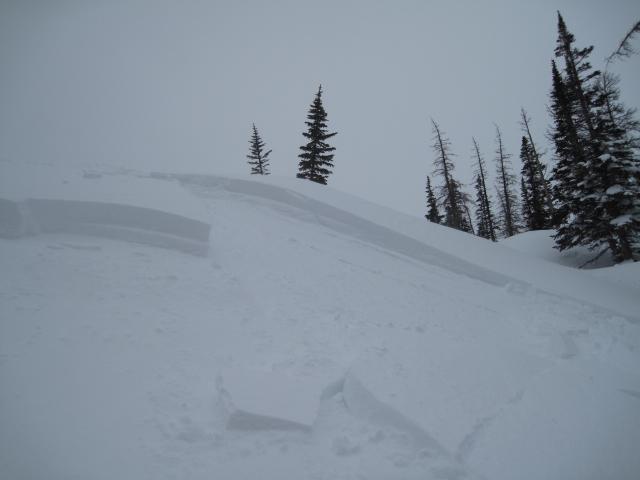
It was an active day across the range. Ted was in the Gold Hill zone (image above) while Weston Shirey stomped around Wolf Creek. Miles apart, but both of these avy-savvy snow-pros found tender wind drifts reactive to their additional weight as they traveled near steep, leeward slopes.
Plenty of avy activity to peruse if ya wanna geek out... click HERE to track this years slide activity throughout the range.
Ad
Avalanche Problem #1
Wind Drifted Snow
Type
Location
Likelihood
Size
Description
Windy Peak (10,662') is not only the place we manufacture wind, it's also the gold standard for wind data. Above is a 24 hour run illustrating recent trends in wind direction, duration, and speed.
Yesterday's tender wind drifts are a precursor to todays bigger, badder brother... and once triggered, they're gonna be packing a powerful punch. Steep wind drifted slopes facing the north half of the compass will react to our additional weight and today's avalanches will break deeper and wider than you might expect, so avoidance is the key to riding safely today. Look for and avoid fat, rounded pieces of snow, especially if they sound of feel hollow like a drum. Give this avalanche dragon the respect it deserves and be ready to pump the brakes on objectives if you're seeing shooting cracks out in front your your skis, board, or sled.

Avalanche Problem #2
New Snow
Type
Location
Likelihood
Size
Description
New snow avalanches are the flavor of the day around the compass and at all elevations. While today's storm snow instabilities are generally short-lived lived and mostly manageable is size and depth, remember, even a small slide can catch you off guard and knock you off your feet, especially in sustained, steep terrain.
Additional Information
Weather stations-
And... rime events have severely crippled the Uinta weather station network. I'm working to get it back up and running, but a few stations are found HERE (click weather stations, and then on the Western Uinta tab)
Observations-
Your observations are important, so please let me know what you're seeing... click HERE and contribute to this amazing community-based program
General Announcements
Issued at 03:27 on Sunday March 5th this forecast expires 24 hours after the date and time posted, but will be updated by 07:00 Monday March 6th 2023.
Before it gets too crazy, now is the time to book an avalanche awareness presentation for your group, club, or posse. You can reach Craig directly at 801-231-2170 or [email protected].

This forecast is from the U.S.D.A. Forest Service, which is solely responsible for its content. This forecast describes general avalanche conditions and local variations always occur.