Forecast for the Uintas Area Mountains

Craig Gordon
Issued by Craig Gordon for
Saturday, March 4, 2023
With more snow and wind on tap, this mornings avy danger may bump up a notch as today's storm evolves-
For this morning... MODERATE avalanche danger exists on steep, leeward slopes in the wind zone at and above treeline. Human triggered avalanches are POSSIBLE, especially in wind drifted terrain facing the north half of the compass, and particularly slopes with an easterly component to its aspect. Today's slides might be a little hard to trigger, but they'll pack a punch and will definitely boss you around.
If you're looking for LOW avalanche danger, you came to the right place and have I got a deal for you! Excellent riding conditions are found on most mid and lower elevation slopes around the dial of the compass and human triggered avalanches UNLIKELY.

Low
Moderate
Considerable
High
Extreme
Learn how to read the forecast here
Special Announcements
Come out and ride for a cause! Utah Snowmobile Association's 6th annual RALLY IN THE VALLEY is today Saturday, March 4th at the cabins at Bear River Lodge. Bring family and friends to join in the fun! All the proceeds from RALLY IN THE VALLEY go directly to supporting the sport in our state. More deets found HERE
Also... to help you safely enjoy the backcountry, the UAC team is constantly evaluating and implementing new programs and technologies. Donate to the Spring Campaign to help our team implement innovative tools and better provide you
Weather and Snow
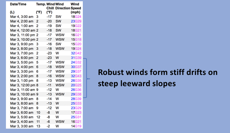
Nowcast- A band of high clouds drift into the eastern front early this morning ahead of a nice shot of snow slated to arrive by about midday. In the meantime, cold air settled into the region overnight and temperatures currently hover right around 0 F, -17 C, or 273 K... for all the Kelvin fans in the audience. However you slice it, it's been a cold winter and this morning fits the mold. Yesterday's westerly winds blew in the 40's, took a brief break at the turn of the new day, shifted to the southwest, and currently blow 20-30 mph near the high peaks. On a go-anywhere base and with nearly two feet of storm snow stacking up since the beginning of the week, riding and turning conditions are all-time.
Forecast- Southwest winds blow in the 40's along the high ridges, clouds thicken as the day wares on, and we can expect a couple inches of snow by sunset. High temperatures barely creep into the low 20's and overnight lows dip into the single digits.
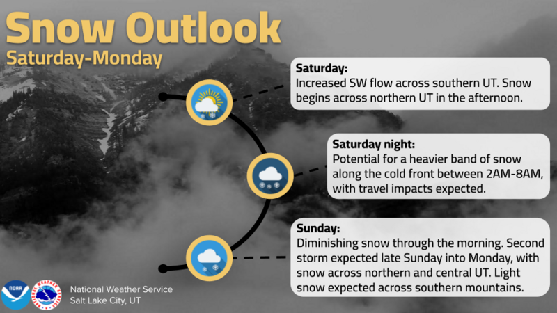
Futurecast- The storm delivers a foot of snow by Sunday morning with scattered snow showers on tap as the day progresses. An active pattern kicks off the work week with storminess nearly everyday.
The graphic above lays out the timeline for our next series of weather systems.
Detailed trip reports and recent obs are found HERE.
Recent Avalanches
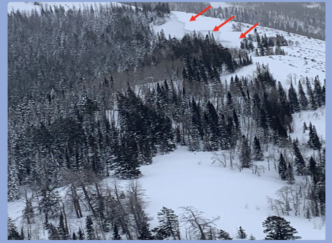
Older news from midweek but worth an honorable mention... a rather well-connected piece of snow avalanched naturally on a steep, leeward, northeast facing slope in the Smith-Moorehouse zone when west and southwest winds were cranking in the 40's and 50's.
Other recent avy activity ... Mt. Watson, to Hoyt Peak, to Double Hill, Upper Chalk Creek, and Browns Canyon all speak to the fact that we've got a big snow year with contiguous snow running tip to tail... from the valley floor to the ridgelines.
No other significant avalanche activity to report, but if ya wanna geek out, click HERE to track this years slide activity throughout the range.
Ad
Avalanche Problem #1
Wind Drifted Snow
Type
Location
Likelihood
Size
Description
Windy Peak (10,662') is not only the place we manufacture wind, it's also the gold standard for wind data. Above is a 24 hour run illustrating recent trends in wind direction, duration, and speed.
Recent wind drifts are a bit sluggish and felt rather well-behaved yesterday. And while I think the vast majority of our terrain is good to go, the Uinta's are a big place and I bet if you wanted to find a wind drift sensitive to your additional weight, there's one lurking out there with your name on it. The most likely place is gonna be in the wind zone, on steep, leeward slopes at and above treeline. So for today, if your getting into big terrain you'll want to look for and avoid fat, rounded pieces of snow, especially if they sound of feel hollow like a drum. Give this avalanche dragon the respect it deserves and be ready to pump the brakes on objectives if you're seeing shooting cracks out in front your your skis, board, or sled.

Additional Information
Weather stations-
And... rime events have severely crippled the Uinta weather station network. I'm working to get it back up and running, but a few stations are found HERE (click weather stations, and then on the Western Uinta tab)
Observations-
Your observations are important, so please let me know what you're seeing... click HERE and contribute to this amazing community-based program
General Announcements
Issued at 03:17 on Saturday March 4th this forecast expires 24 hours after the date and time posted, but will be updated by 07:00 Sunday March 5th 2023.
Before it gets too crazy, now is the time to book an avalanche awareness presentation for your group, club, or posse. You can reach Craig directly at 801-231-2170 or [email protected].

This forecast is from the U.S.D.A. Forest Service, which is solely responsible for its content. This forecast describes general avalanche conditions and local variations always occur.