Forecast for the Uintas Area Mountains

Craig Gordon
Issued by Craig Gordon for
Wednesday, March 8, 2023
And just like that... avalanche danger is quite straight-forward-
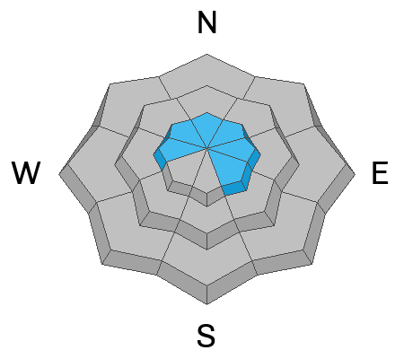
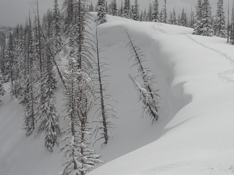
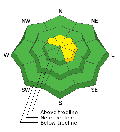
In a sea of green, pockets of MODERATE avalanche danger exist on steep, leeward slopes in the wind zone at and above treeline. While not widespread, human triggered avalanches are POSSIBLE, especially in wind drifted terrain facing the north half of the compass, and particularly on slopes with an easterly component to its aspect.
If you're looking for LOW avalanche danger you came to the right place. Simply steer your snow riding vehicle toward mid and low elevation terrain, especially slopes facing the south half of the compass where human triggered avalanches are UNLIKELY.

Low
Moderate
Considerable
High
Extreme
Learn how to read the forecast here
Special Announcements
To help you safely enjoy the backcountry, the UAC team is constantly evaluating and implementing new programs and technologies. Donate to the Spring Campaign to help our team implement innovative tools and better provide you
Weather and Snow
Nowcast- Southwest winds blow 20-30 mph along the high ridges, helping to usher in a band of thin clouds, which drift over the region early this morning. Temperatures are crisp, hovering in the teens across the board. On a go-anywhere base and with over four feet of storm snow stacking up in the past week, riding and turning conditions are all-time.
Forecast- Look for mostly sunny skies this morning with high temperatures climbing into the upper 20's The buzz-kill are southwest winds, ramping into the 40's and 50's, along with thickening clouds late in the day. A quick hitter delivers cold air and an intense shot of thunder snow right around sunset. Accumulations in the 3"-6" range seems about right.
Futurecast- A break on Thursday delivers sunny skies and temperatures rising into the upper 20's. It's a short-lived respite as a pattern shift slated for Friday brings in a warm, moist, atmospheric river to round out the work week.
Our good friends at the NWS in the City of Salt, lay out the timeline for today's late afternoon precip in the graphic above.
Micheal J found stable snow, straight-forward avy conditions and excellent riding in Lower Weber Canyon yesterday.
Detailed trip reports and recent obs are found HERE.
Recent Avalanches
A quiet day on the eastern front yesterday, but plenty of avy activity to peruse if ya wanna geek out... click HERE to track this years slide activity throughout the range.
Ad
Avalanche Problem #1
Wind Drifted Snow
Type
Location
Likelihood
Size
Description
Ominous overhanging cornice are a clue to both recent and older wind loading events. It'll also give us an idea where we might find a wind drift, reactive to our additional weight on steep, leeward slopes.
Most of our recent storm snow instabilities have settled out nicely in the past few days and are becoming comfortable in their own skin. And that makes sense, because snow is a lot like people and it gets cranky when it goes through a rapid change. However, we have several layers of storm snow that stacked up over the weekend and while they may be harder to initiate, once triggered, today's avalanches will pack a powerful punch. Steep wind drifted slopes facing the north half of the compass is bulls-eye terrain and today's avalanches will break deeper and wider than you might expect... so avoidance is the key to riding safely today. If your objective is tagging sustained steep terrain, consider the consequences of triggering a slide and have an exit strategy in place. Better yet, tweak small test slopes like road banks with characteristics similar to what you wanna ride and see how they're reacting to your additional weight, before blindly center punching a big, committing line.

Additional Information
Shake, rattle, and roll... looking towards Friday and into early next week... warm, wet, and windy! There's a potential for 30"of snow with 2.5" of H2O.
Weather stations-
And... rime events from January's atmospheric rivers severely crippled the Uinta weather station network. I'm working to get it back up and running, but a few stations are found HERE (click weather stations, and then on the Western Uinta tab)
Observations-
Your observations are important, so please let me know what you're seeing... click HERE and contribute to this amazing community-based program
General Announcements
Issued at 03:03 on Wednesday March 8th this forecast expires 24 hours after the date and time posted, but will be updated by 07:00 Thursday March 9th 2023.
Before it gets too crazy, now is the time to book an avalanche awareness presentation for your group, club, or posse. You can reach Craig directly at 801-231-2170 or [email protected].

This forecast is from the U.S.D.A. Forest Service, which is solely responsible for its content. This forecast describes general avalanche conditions and local variations always occur.