Forecast for the Uintas Area Mountains

Craig Gordon
Issued by Craig Gordon for
Thursday, March 7, 2019
HEADS UP.... THE AVALANCHE DANGER IS SLIGHTLY HIGHER ON THE SOUTH HALF OF THE RANGE, FROM TRIAL LAKE TO STRAWBERRY-
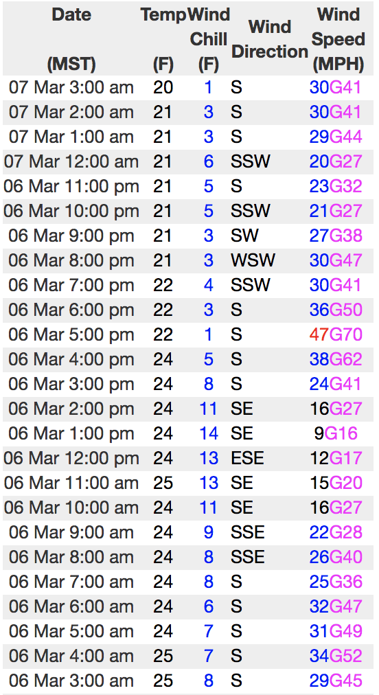
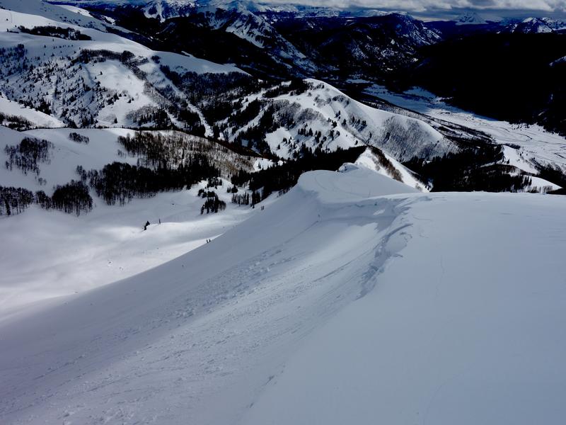
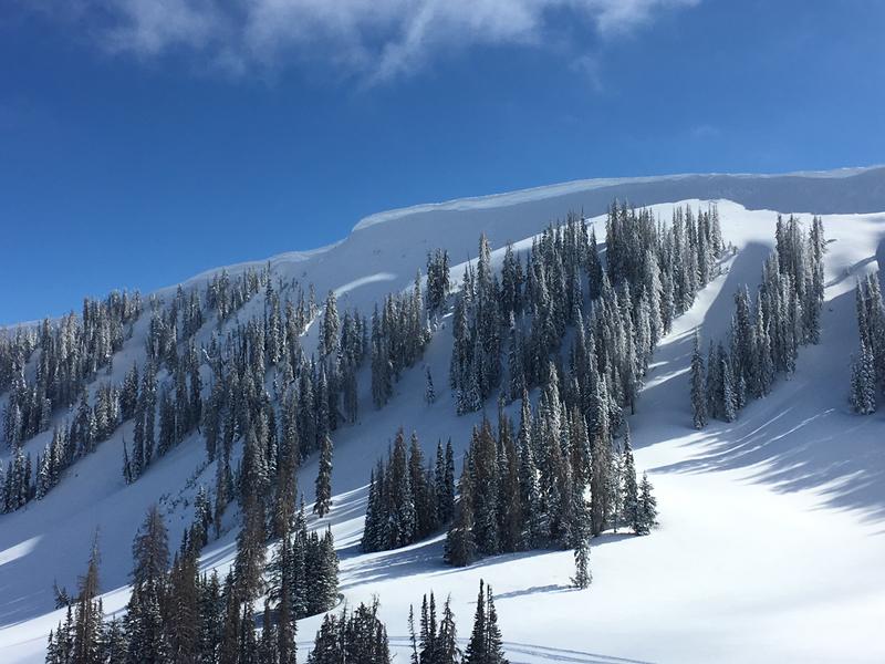
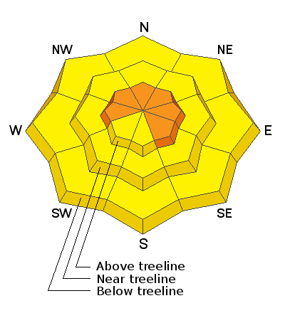
In the wind zone, at and above treeline, you'll find CONSIDERABLE avalanche danger. Human triggered avalanches are LIKELY and natural avalanches POSSIBLE on steep wind drifted slopes, especially those facing the north half of the compass and particularly those with an easterly component to their aspect. Any avalanche that breaks into deeper buried weak layers near the ground will result in a deep, dangerous slide.
Mid elevation, wind drifted terrain offers MODERATE avalanche danger and human triggered avalanches are POSSIBLE.
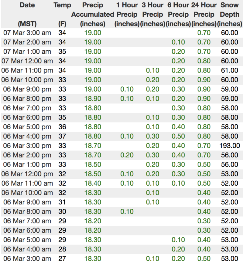
Rain on snow at lower elevations has created MODERATE avalanche danger near trailheads and in our mountain valley communities. Human triggered wet avalanches are POSSIBLE on steep snow covered slopes
Low
Moderate
Considerable
High
Extreme
Learn how to read the forecast here
Special Announcements
HEADS UP for ROOF AVALANCHES or (ROOFALANCHES): Recent warm temperatures and rain conspired against many steep roofs in our mountain communities, making the winter snowpack which rests on top of them unstable. Please alert your friends and family who may not normally check avalanche forecasts. Roof avalanches are potentially deadly, especially for children.
A big thanks to my friend Matt Rollins for providing the viddy above
Weather and Snow
Yesterday's, moist, warm southwest flow lit up the south half of the range where nearly a foot of dense, heavy snow stacked up in the past 24 hours. From Trial Lake northward, most areas only received about half that amount, but have just started turning on and should quickly catch up, especially with tonights storm. In either case southerly winds didn't discriminate and they've been busy at work since Wednesday afternoon blowing in the 30's and 40's along the high ridges. Temperatures are mild and in the mid 20's and low 30's. Today you'll find a mixed bag of snow surface conditions, but don't be discouraged, head to mid elevation wind sheltered terrain and you'll be rewarded with soft, creamy snow.
Above is hourly data from Currant Creek (7,914') and Windy Peak (10,662'). To view more regional weather stations click here.
JG was in Upper Weber Canyon Monday. More on his travels here.
Recent Avalanches
Avalanche activity is changing as the storm evolves. Dave Kikkert stomped around Upper Weber Canyon Tuesday and found shallow, yet reactive, fresh wind slabs along the leeward side of upper elevation ridges (image pictured above). He was out yesterday and noted.... "since the new snow is a bit denser, wind slabs, once initiated, were breaking a bit wider than expected. With additional loading tonight/tomorrow, expect these to be a bit deeper and more connected tomorrow"
Recent trip reports and avy activity found HERE.
Ad
Avalanche Problem #1
Wind Drifted Snow
Type
Location
Likelihood
Size
Description
Winds ramped up late yesterday and continued overnight, forming fresh drifts that'll react to our additional weight. With a few more inches of dense heavy snow to work, today's drifts are gonna be a bigger brother version of what we dealt with yesterday. As a matter of fact, I suspect drifts are more widespread, more connected, and will break deeper than you might expect. In general, I think today's drifts will predictably break at or below our skis, board, or sled, and today you'll wanna look for and avoid any fat, rounded piece of snow, especially if it sounds hollow like a drum.
And don't forget-
Cornices are ginormous and may break back further than you might expect. You definitely wanna give these large, unpredictable pieces of snow a wide berth and not ruin someones day below by inadvertently knocking a boxcar size piece of snow down on them
Avalanche Problem #2
Persistent Weak Layer
Type
Location
Likelihood
Size
Description
We are trending in the right direction and recent snowpack stability tests along with the lack of avalanches failing on weak snow near the ground suggest we're turning the corner. Also streaming in from the good news department is this... most terrain where the snowpack is becoming thick and strong, deep dangerous avalanches are becoming harder to trigger. All encouraging news for sure, but we've got to remember there's a lot of terrain that makes up the landscape of the western Uinta range and I'm not entirely convinced all slopes are good to go. However, our theories will get tested as the next series of storms should add a substantial amount of snow and water and help us determine the strength of our deeply buried weak layers. In the meantime, let's reflect on how persistent weak layers work and remember that all I need to do is find a shallow, weak portion of the snowpack, perhaps around a rock or bush that I can't see underneath the snow, collapse the slope (whoomph), and now I'm staring down the barrel of a dangerous avalanche. What I don't know... where exactly these weak points exist in the snowpack, but steep rocky slopes are certainly high on the suspect terrain list and should be avoided today.
Additional Information
Expect a couple more inches of snow this morning, then a bit of an afternoon break before another colder system slides through the region tonight. High temperatures reach into the mid 30's with overnight lows in the 20's. South and southwest winds blow in the 40's and 50's early this morning, but taper off slightly as the day progresses. An active pattern continues into next week.
General Announcements
The information in this advisory expires 24 hours after the date and time posted, but will be updated by 7:00 AM Friday March 8th, 2019.
If you're getting out and about, please let me know what you're seeing especially if you see or trigger and avalanche. I can be reached at [email protected] or 801-231-2170
It's also a good time to set up one of our very popular avalanche awareness classes. Reach out to me and I'll make it happen.
This information does not apply to developed ski areas or highways where avalanche control is normally done. This advisory is from the U.S.D.A. Forest Service, which is solely responsible for its content. This advisory describes general avalanche conditions and local variations always occur.