Forecast for the Uintas Area Mountains

Craig Gordon
Issued by Craig Gordon for
Thursday, March 2, 2023
The walls aren't caving in around us, but please don't let sunny skies and fresh pow take charge of your decision making today-
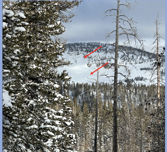
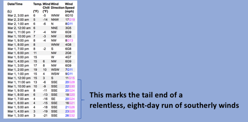
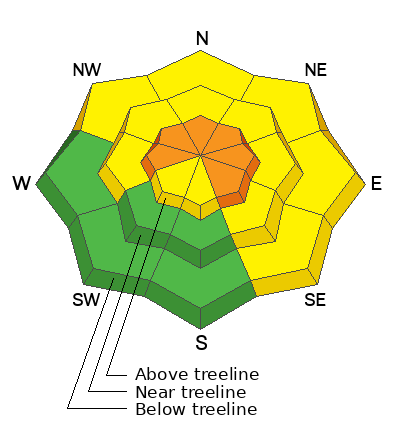
CONSIDERABLE avalanche danger exists on steep, leeward slopes in the wind zone at and above treeline. Human triggered avalanches are LIKELY, especially in wind drifted terrain facing the north half of the compass, and particularly slopes with an easterly component to its aspect. While not as obvious or widespread, recent winds penetrated into mid and lower elevation terrain (around our trailheads) and you'll find MODERATE danger. Human triggered avalanches are POSSIBLE on steep slopes with recent deposits of wind drifted snow. In either case, today's slides pack a punch and will definitely boss you around.
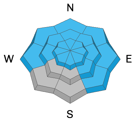
Here's your exit strategy... LOW avalanche danger exists on many mid and lower elevation slopes facing the south half of the compass.

Low
Moderate
Considerable
High
Extreme
Learn how to read the forecast here
Special Announcements
Come out and ride for a cause! Utah Snowmobile Association's 6th annual RALLY IN THE VALLEY is being held March 4th at the cabins at Bear River Lodge. Bring family and friends to join in the fun! All the proceeds from RALLY IN THE VALLEY go directly to supporting the sport in our state. More deets are found HERE
Also... to help you safely enjoy the backcountry, the UAC team is constantly evaluating and implementing new programs and technologies. Donate to the Spring Campaign to help our team implement innovative tools and better provide you
Weather and Snow
Nowcast- Overnight, a band of clouds slid in from the north, producing a couple traces of snow and winter-like temperatures which hover right around zero and in the single digits early this morning. The recent onslaught of southerly winds finally tapered off midday Wednesday, switched to the north, and currently blow 10-20 mph near the high peaks. On a go-anywhere base and with nearly two feet of storm snow stacking up since the beginning of the week, riding and turning conditions are all-time.
Forecast- A few scattered snow showers linger this morning, but those taper of right around sunrise and short-lived high pressure delivers sunny skies. We slowly crawl out of the deep freeze with today's high temperatures reaching into the mid 20's. North and northwest winds add a bite to the air as they blow in the 20's and 30's along the high ridges.
Futurecast- Clouds increase late in the day as a quick-hitter slides through the area late tonight into Friday, ushering in a weak storm and an inch or two of snow. A break for Saturday with another system lining up to round out the weekend.
Detailed trip reports and recent obs are found HERE.
Recent Avalanches
Shaun Raskin... Inspired Summit Adventures business owner, guide extraordinaire, and of course, remarkable human (we need more Shaun's in the world :) submitted this recent avy ob above. Most likely occurring in the past day or two as a result of strong southeasterly winds, Shaun's keen eye spotted a natural pocket on a steep, WNW facing slope, east of Castle Peak yurt.

More slides from the weekend ... Mt. Watson, to Hoyt Peak, to Double Hill, Upper Chalk Creek, and Browns Canyon all speak to the fact that we've got a big snow year with contiguous snow running tip to tail... from the valley floor to the ridgelines.
No other significant avalanche activity to report, but if ya wanna geek out, click HERE to track this years slide activity throughout the range.
Ad
Avalanche Problem #1
Wind Drifted Snow
Type
Location
Likelihood
Size
Description
Data dump from Windy Peak (10,662'), shows an end to the weeks-long southerly winds.
Generally from the south, winds began cranking right around suppertime on February 22nd and with no shortage of snow to blow around, drifts have been stacking up on the leeward side of ridges for over a week. Found mostly in the wind zone above treeline, due to strength and duration, plenty of fresh drifts formed in lower elevations as well. Here's where it gets tricky... drifts are hidden by a shallow coat of white paint, making them harder to detect. So for today, you'll want to look for and avoid fat, rounded pieces of snow, especially if they sound of feel hollow like a drum. Give this avalanche dragon the respect it deserves and know avoidance is the ticket. Be ready to pump the brakes on objectives if you're seeing shooting cracks out in front your your skis, board, or sled.

Additional Information
Weather stations-
And... rime events have severely crippled the Uinta weather station network. I'm working to get it back up and running, but a few stations are found HERE (click weather stations, and then on the Western Uinta tab)
Observations-
Your observations are important, so please let me know what you're seeing... click HERE and contribute to this amazing community-based program
General Announcements
Issued at 03:09 on Thursday March 2nd this forecast expires 24 hours after the date and time posted, but will be updated by 07:00 Friday March 3rd 2023.
Before it gets too crazy, now is the time to book an avalanche awareness presentation for your group, club, or posse. You can reach Craig directly at 801-231-2170 or [email protected].

This forecast is from the U.S.D.A. Forest Service, which is solely responsible for its content. This forecast describes general avalanche conditions and local variations always occur.