Wanna share a cuppa... Joe, interested in this years snowpack trends, or maybe just NSF curious? Well then, you came to the right place! Please join me at 6:30, Alpha Coffee on Wednesday March 2nd and we can discuss the future of snowpack stability trends together. Save the date, take a date, and I look forward to seeing you there :)
NOWCAST-
High thin clouds drifted into the region overnight, keeping a lid on temperatures which are tropical this morning, registering right around freezing. Southwest winds are generally well-behaved, blowing just 15-25 mph even near the high peaks. Mid and lower elevation sunny slopes have cooled overnight, offering supportable melt-freeze crusts and corn (the snow surface... not the vegetable). Swing over to the north half of the compass and you'll still find soft, recycled snow on mid and upper elevation shady slopes, but with just a touch of sun, it quickly turns to hot-pow.
FORECAST-
Partly cloudy skies and very warm temperatures are on tap with highs once again soaring into the mid and upper 40's. Southwest winds blow in the teens and mid 20's.
FUTURECAST-
And in-between day and weather no-mans land for Thursday, so get your chores done, because snow showers begin across the higher terrain mid-day Friday, with precipitation filling in across lower elevations by evening. Colder air slides through the area on Saturday bringing another round of snow with a final piece of energy on Monday. Whilst a multi-day weather event, storm totals still don't look all that impressive only with 6"-8" of snow stacking up.
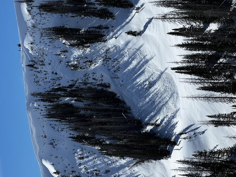
Trip reports and current state of the snowpack observations are found
HERE.
Looking for real-time temps, snow, or wind?
Click HERE and then on the "western Uinta" tab for western Uinta specific, weather station network.
Reported yesterday from a steep northeast facing slope Upper Moffit Basin. A cornice released naturally, peeling off a shallow soft slab near the ridge, crashing down on the slope below which broke into weak faceted snow, triggering a much larger slide than you might expect... 2' deep, 200' wide, running 400' vertical Thanks to Bayou Dave for the nearly instant report yesterday and all the great info!