

Forecast for the Uintas Area Mountains

Issued by Craig Gordon on
Thursday morning, March 3, 2022
Thursday morning, March 3, 2022
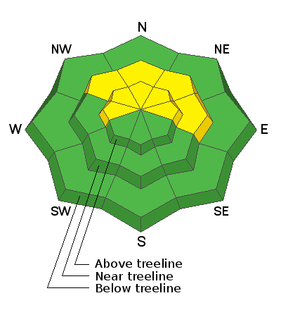
MODERATE avalanche danger is found at and above treeline, especially on slopes facing the north half of the compass where soft, cohesive slabs and wind drifts rest on top of weak, sugary snow. Human triggered avalanches are POSSIBLE and may break deeper and wider than you might expect. In terrain where last weeks winds haven't drifted snow, especially at mid and lower elevations, the avalanche danger is LOW and human triggered avalanches are UNLIKELY.
Low
Moderate
Considerable
High
Extreme
Learn how to read the forecast here
 Special Announcements
Ginormous thanks to Carl Churchill and Alpha Coffee for hosting and to everyone who took time out of their busy lives and came out for my State of the state of the snowpack preso last night! What an amazing night, energy, and vibe... y'all rock and I was super stoked to see so many old friends and make a few new ones as well :)
 Weather and Snow
NOWCAST-
What a way to run a winter! High thin clouds draped our mountains overnight and an already warm airmass is in place, so it's downright tropical with temperatures hovering right around freezing across the board. Southwest winds are on the rise and began bumping into the mid 20's at midnight. Corn is elusive and patches of cool snow intersect with hot pow on sheltered, shady slopes... maybe it's a good day to get chores done as the snowpack took a big hit yesterday.
FORECAST-
The warm before the storm. Expect thickening clouds with very warm temperatures soaring into the 50's. Southwest winds don't get too out of hand, but ramp up into the 40's as the day wares on.
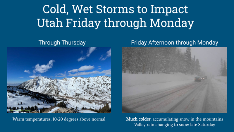
FUTURECAST-
Several rounds of snow head our way to wrap up the work week and the first system arrives Friday afternoon into Saturday. Not a big storm, but enough for a 2"-4" reset. A break is expected Saturday morning with another colder spoke in the weather wheel poised to slide through Saturday afternoon and Sunday, stacking up an additional 3"-6" of snow. Snow showers linger through Monday and storm totals in the 6"-10" snow with .80" H2O seem optimistically reasonable.
Trip reports and current state of the snowpack observations are found HERE.
Looking for real-time temps, snow, or wind?
Click HERE and then on the "western Uinta" tab for western Uinta specific, weather station network.
 Recent Avalanches

Yesterday, Andy and I looked at an interesting slide triggered Tuesday on a steep northeast facing slope in Upper Moffit Basin. A cornice released naturally, peeling off a shallow soft slab near the ridge, crashing down on the slope below which broke into weak faceted snow, triggering a much larger slide than you might expect... 2' deep, 200' wide, running 400' vertical Thanks to Bayou Dave for the nearly instant report Tuesday and all the great info!
Your input is vital and we're interested in what you're seeing. Please contribute to this great community resource and go here to fill out an observation.

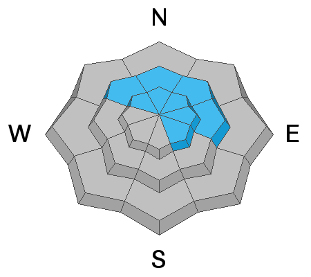
Avalanche Problem #1
Persistent Weak Layer
Type
Location
Likelihood
Size
Description
As temperatures continuing warming today and the last weeks cold snow begins to settle, pockety slabs will become touchy, reactive to our additional weight, and may break deeper and wider than you might expect.
The heat is on and it's effecting our snowpack as last week's low density storm snow is settling and becoming more cohesive (a slab). It's not a rapid change, but the weak, sugary, near surface facets (NSF) formed during the January/February dry-spell are coming out of their dormancy and back to life. Walking around on the bed surface of a recently triggered slide and digging right next to it, makes me realize just how weak the NSF have grown over time. Man, it's nothin' but shugga... baby, and it's not going to take much of a load before the wheels come off. The weakest snow I've found is on east, north, and northeast aspects, especially on mid and upper elevation wind sheltered slopes. Here's where it gets tricky... large swaths of upper elevation terrain facing the north half of the compass were blasted by the winds prior to our recent storms and weak snow distribution is spotty at best. That means you'll need to evaluate each slope on an individual basis.
A sidebar HEADS UP - It's easy to be complacent because conditions aren't too dangerous, and avalanches may not be too big. HOWEVER, an avalanche fatality earlier this month in Montana near West Yellowstone is an example of how a relatively small avalanche can be deadly. That avalanche was 4-11 inches deep and 75 feet wide. Read more HERE.
Additional Information
Your observations are important, so please let me know what you're seeing... click HERE and contribute to this amazing community based program
General Announcements
The information in this forecast expires 24 hours after the day and time posted, but will be updated by 07:00 Friday, March 4th.
Before it gets too crazy, now is the time to book an avalanche awareness presentation for your group, club, or posse. You can reach me directly at 801-231-2170 or [email protected]
This forecast is from the U.S.D.A. Forest Service, which is solely responsible for its content. This forecast describes general avalanche conditions and local variations always occur.