Forecast for the Uintas Area Mountains

Craig Gordon
Issued by Craig Gordon for
Saturday, March 11, 2023
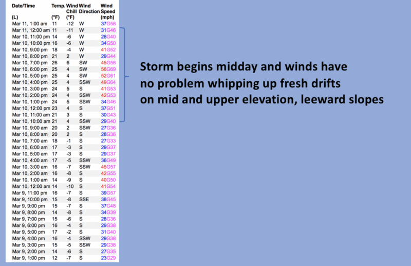
Heads up.... ripping winds and fresh snow create dangerous avalanche conditions-
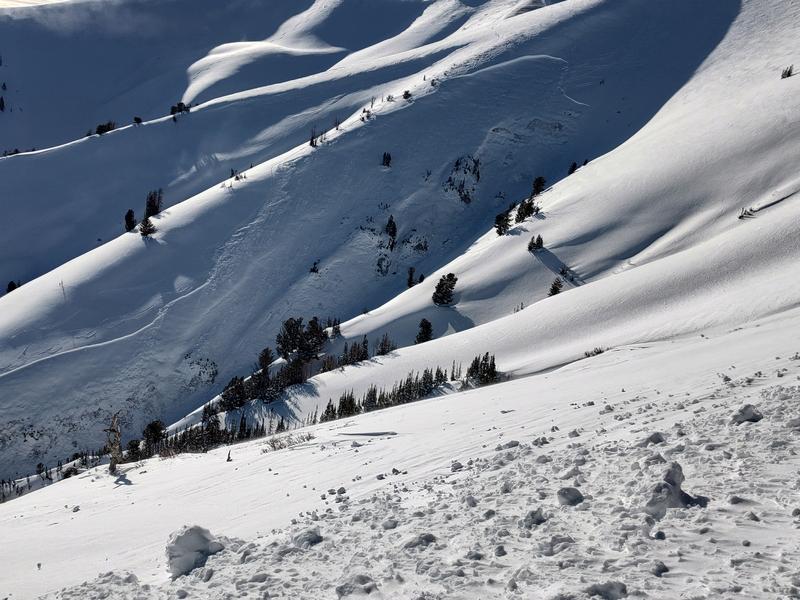
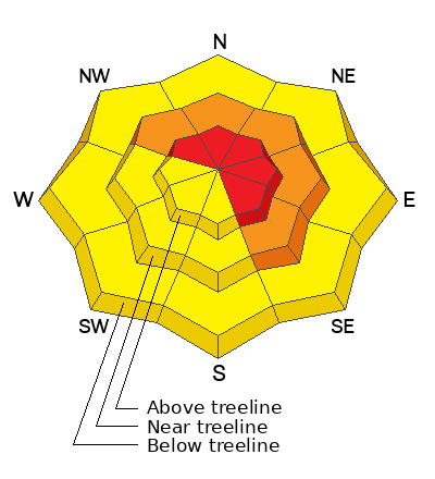
Pockets of HIGH avalanche danger are found on steep, upper elevation leeward slopes, especially in the wind zone on drifted terrain facing the north half of the compass. Human triggered avalanches are VERY LIKELY, particularly on slopes with an easterly component to their aspect. Winds and storm snow conspire to create CONSIDERABLE avalanche danger on mid elevation shady slopes and human triggered avalanches are LIKELY in steep terrain.
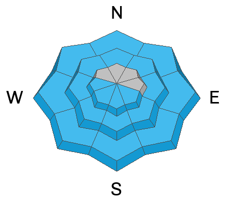
MODERATE avalanche danger is found at lower elevations where fresh snow takes on heat and human triggered avalanches are POSSIBLE on all steep, snow covered slopes... think foothills and trailheads.

Low
Moderate
Considerable
High
Extreme
Learn how to read the forecast here
Weather and Snow
Nowcast- Last night's storm delivered an all-you-can-eat buffet of all things weather... sheets of valley rain, nearly hurricane force winds, and yes... even THUNDERSNOW! That all translates to a whole 'lotta weather and about 10" of snow with .70" of H2O. Cooler air is settling into the region and temperatures are beginning to march towards the mid teens. Winds switched to the west around 8:00 last night, but remain a nuisance, blowing 30-50 mph along the high ridges. Riding and turning conditions are all-time and continue their string of 5 star Yelp reviews.
Forecast- A beautiful day is on tap with mostly sunny skies, temperatures rising into the upper 20's and westerly winds tapering off as the day wares on. Mostly cloudy skies develop late today with snow showers expected overnight.
Futurecast- After a brief break in the action kicks off the workweek, with another area wide storm in the queue, slated to arrive Tuesday and Wednesday.
Detailed trip reports and recent obs are found HERE.
Recent Avalanches
I am deeply saddened to report a very tragic avalanche accident. Two skiers were caught and buried in a large avalanche in Upper Weber Canyon Thursday. One skier was successfully rescued and is recovering. Sadly, the second skier was buried deeper and did not survive. A preliminary report is available HERE.
Otherwise, nothing to report from Friday, but plenty of avy activity to peruse if ya wanna geek out... click HERE to track this years slide activity throughout the range.
Ad
Avalanche Problem #1
Wind Drifted Snow
Type
Location
Likelihood
Size
Description
Not as enthusiastic to go to work as I am this morning (slacker :) Windy Peak is a workhorse none-the-less, delivering consistent 'round the clock data.
Winds are always the game changer for the Uinta's and last nights storm continues in that long-standing tradition. Heavy snow coupled with strong winds piled up multiple layers of storm snow on steep, leeward slopes, especially those facing the north half of the compass. And while our snowpack is relatively strong, yesterday's storm came in fast and furious and will reveal any weaknesses or chinks in the armor. So today's avalanches will break deeper and wider than you might expect. In other words... there's enough volume to easily knock to off your feet and take you for an unexpected ride. If your objective is tagging sustained steep terrain, please consider the consequences of triggering a slide and have an exit strategy in place. No mystery here as this avalanche dragon is straight-forward and easy to avoid. Lose the wind and you lose the problem.

Avalanche Problem #2
Wet Snow
Type
Location
Likelihood
Size
Description
The sun is high in the sky and fresh snow will take on heat, easily reacting to our additional weight, especially at lower elevations. That means we need to think about avoiding steep sun-exposed slopes across the board, particularly around our trailheads and foothills.
Additional Information
Weather stations-
And... rime events from January's atmospheric rivers severely crippled the Uinta weather station network. I'm working to get it back up and running, but a few stations are found HERE (click weather stations, and then on the Western Uinta tab)
Observations-
Your observations are important, so please let me know what you're seeing... click HERE and contribute to this amazing community-based program
General Announcements
Issued at 03:27 on Saturday March 11th this forecast expires 24 hours after the date and time posted, but will be updated by 07:00 Sunday March 12th 2023.
Before it gets too crazy, now is the time to book an avalanche awareness presentation for your group, club, or posse. You can reach Craig directly at 801-231-2170 or [email protected].

This forecast is from the U.S.D.A. Forest Service, which is solely responsible for its content. This forecast describes general avalanche conditions and local variations always occur.