Forecast for the Uintas Area Mountains

Craig Gordon
Issued by Craig Gordon for
Sunday, March 12, 2023
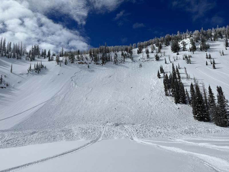
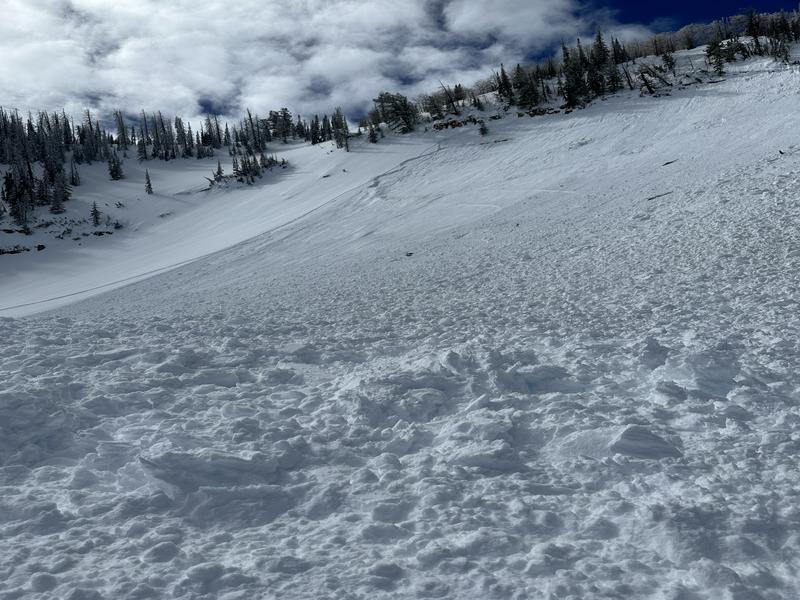
Yesterday's strong sunshine helped shrink-wrap many slopes, but don't let your guard down-
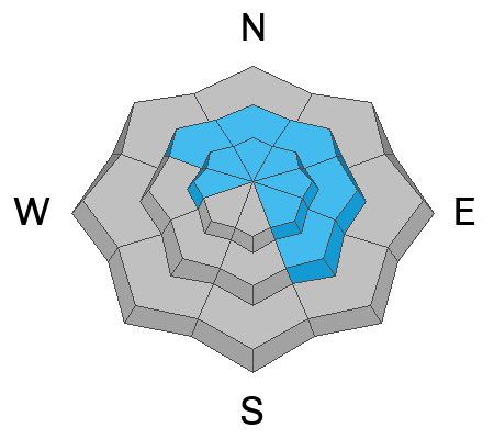
Pockets of CONSIDERABLE avalanche danger are found on steep, upper elevation leeward slopes, especially in the wind zone on drifted terrain facing the north half of the compass. Human triggered avalanches are PROBABLE, particularly on slopes with an easterly component to their aspect. Steep, mid elevation elevation slopes offer MODERATE avalanche danger and human triggered avalanches are possible on steep, shady slopes with recent deposits of wind drifted snow.
You'll find LOW avalanche danger on most lower elevation terrain and slopes facing the south half of the compass.

Low
Moderate
Considerable
High
Extreme
Learn how to read the forecast here
Special Announcements
I am currently working with the operation involved in Thursday's avalanche accident in Weber Canyon and preparing a report. Please be patient as I sort out the details of this complicated incident. A preliminary report is available HERE.
Weather and Snow
Nowcast- High, thin clouds drift into the region this morning, as a weak system brushes the north half of the state. Temperatures register in the teens and low 20's, while west-southwest winds blow in the mid 20's along the high ridges. Yesterday's strong sunshine baked a lot of our terrain, but cold, settled snow is still found on mid and upper elevation shady slopes.
Forecast- A passing snow shower or two delivers a couple inches of snow, but I don't think it's anything to get too excited about. Temperatures don't vary much from where we're at this morning, only climbing into the upper 20's. Westerly winds remain relatively well-behaved, blowing in the 20's and 30's near the high peaks.
Futurecast- A brief break in the action kicks off the workweek, whilst another area wide storm is in the queue, slated to arrive Tuesday and Wednesday.
Above is a timeline for the next couple days, crafted by our good friends at the NWS located right here in the City of Salt.
Detailed trip reports and recent obs are found HERE.
Recent Avalanches
Friday night's storm offered two very distinctly different avalanche dragons
On the north half of the compass, Max reported a well connected, sled triggered, dry slab avalanche on a steep, wind drifted slope near Hoyt Peak.
On the south half of the compass, during the heat of the storm, this natural avalanche dribbled onto US 40 near Daniels Summit.
In addition, plenty of avy activity to peruse if ya wanna geek out... click HERE to track this years slide activity throughout the range.
Ad
Avalanche Problem #1
Wind Drifted Snow
Type
Location
Likelihood
Size
Description
Today's avalanches, like this piece of snow in the image above near Hoyt Peak on Saturday, will still pack a powerful punch today.
Good news... spring is a remarkable time of year. I get to work on my tan, the days are exponentially longer, and storm snow instabilities settle and gain strength rather quickly.
Flake news... don't get lulled into a false sense of security by the lack of avalanche activity or signs of instability. Friday's storm rolled through the region like a cross-fire hurricane, along with very strong winds, nearly a foot of snow stacked up in short order. While I think today's avalanches are slightly more stubborn and harder to trigger, they'll break deeper and wider than you might expect. In other words... there's enough volume to easily knock you off your feet and take you for an unexpected ride. If your objective is tagging sustained steep terrain, please consider the consequences of triggering a slide and have an exit strategy in place. No mystery here as this avalanche dragon is straight-forward and easy to avoid. Lose the wind and you lose the problem.

Additional Information
Weather stations-
And... rime events from January's atmospheric rivers severely crippled the Uinta weather station network. I'm working to get it back up and running, but a few stations are found HERE (click weather stations, and then on the Western Uinta tab)
Observations-
Your observations are important, so please let me know what you're seeing... click HERE and contribute to this amazing community-based program
General Announcements
Issued at 03:37 on Sunday March 12th this forecast expires 24 hours after the date and time posted, but will be updated by 07:00 Monday March 13th 2023.
Before it gets too crazy, now is the time to book an avalanche awareness presentation for your group, club, or posse. You can reach Craig directly at 801-231-2170 or [email protected].

This forecast is from the U.S.D.A. Forest Service, which is solely responsible for its content. This forecast describes general avalanche conditions and local variations always occur.