March Kicks Off Our Spring Campaign- Donate Now to Support Forecasting

Forecast for the Uintas Area Mountains

Mark Staples
Issued by Mark Staples on
Friday morning, February 26, 2021
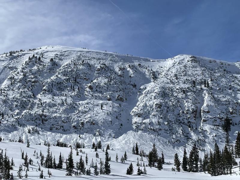
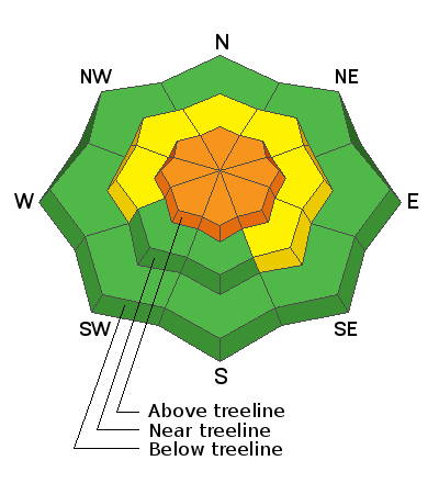
Today the avalanche danger above treeline is CONSIDERABLE. It has become harder to trigger avalanches, BUT they will be deep, wide, destructive and deadly.

Near treeline, the danger is MODERATE where large and deadly avalanches remain possible.

Below treeline the avalanche danger is LOW where avalanches are unlikely. However, a low danger does not mean no danger. Avalanches can still happen which is why we always carry avalanche rescue gear and expose only one person at a time to avalanche terrain.
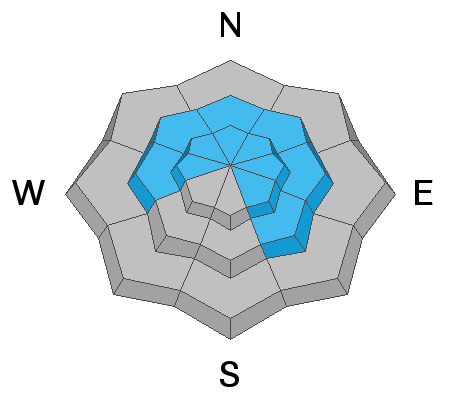
Low
Moderate
Considerable
High
Extreme
Learn how to read the forecast here
Special Announcements
If you missed the Wilson Glade Accident Q&A Webinar, you can watch the recording HERE. This is an excellent opportunity to learn from the accident recap and questions from the backcountry community.
Toby and Paige are working on a report from last Saturday's accident near Sherman Peak near Preston, ID. Read the preliminary report HERE.
Weather and Snow
Nowcast-
It's cold and windy this morning with temperatures in the low teens and single digits F. Winds are blowing from the west and southwest 20-30 mph and gusting 40-50 mph at upper elevations. At lower elevations, winds are averaging 10 mph gusting 15-20 mph.
Forecast-
Some snow should fall this morning but the main storm starts this afternoon. Temperatures will only warm about five degrees today. Strong to moderate winds will continue from the west and southwest.
Futurecast-
Snowfall should continue into Saturday evening with a total of 6-10 inches of low density snow. Temperatures will be in the single digits F on Saturday. Sunday will be sunny with high temperatures only in the teens F.

Looking for real-time temps, snow, or wind?
Click here and then on the "western Uinta" tab for western Uinta specific, weather station network.
Recent Avalanches
Yesterday, Andy Nasetta spotted several recent avalanches of wind drifted snow near Reids Peak.
Two large avalanches happened on Tuesday. One slide was intentionally triggered slide with explosives in Upper Weber Canyon that Craig describes in the video below. The other large slide happened on Mt Marsell just north of Mirror Lake.

More obs, trip reports, and avalanches found here.
Ad
Avalanche Problem #1
Persistent Weak Layer
Type
Location
Likelihood
Size
Description
Throughout the Uinta Mountains, there is a slab 2-5 feet thick resting on a persistent weak layer (PWL) of facets about a foot above the ground. This PWL exists on most slopes except ones facing due south and southwest.
This PWL has adjusted to the weight and stress of new snow that fell last week, and the likelihood of triggering an avalanche has gone down. However the snowpack layering remains the same, and the consequences of an avalanche remain deadly. The most likely slopes to avalanche are ones with the added weight of wind drifted snow. The most likely trigger points are (1) where the snowpack is generally thinner, (2) near the edges of drifts, or (3) in thin spots near rocks.
Areas with deeper snow make it harder for a skier or rider to impact facets near the bottom of the snowpack. In the large avalanche Craig describes in the video above, several explosives were deployed on that slope with no effect. That avalanche didn't happen until an explosive went off in just the right spot. This means we can ride a slope and it may not avalanche until someone rides over a thin spot.
Below is an image of the snowpack in the Mill Creek area just east of Bear River from Tuesday. Notice the weak snow near the ground highlighted by Ted's snow saw.
Avalanche Problem #2
Wind Drifted Snow
Type
Location
Likelihood
Size
Description
Strong northwest winds blew on Tuesday followed by strong northeast winds yesterday morning. This morning strong winds are blowing from the west and southwest.
These winds have formed slabs of wind drifted snow on many different aspects mostly at upper elevations above treeline. These wind slabs can produce an avalanche on their own. These wind slabs also add weight and stress to weak, faceted snow near the ground.
Today and especially tomorrow, drifts and wind slabs that formed this week will be covered in new snow and harder to see.
Additional Information
Map of expected snowfall by Sunday morning
We will update this forecast by 7:00 AM tomorrow, Saturday, February 27th.
Your observations are important, so please let me know what you're seeing... click HERE and contribute to this amazing community based program
General Announcements
If you see or trigger an avalanche or just wanna let me know what you're seeing you can reach me directly at 801-231-2170 or [email protected]
This forecast is from the U.S.D.A. Forest Service, which is solely responsible for its content. This forecast describes general avalanche conditions and local variations always occur.