March Kicks Off Our Spring Campaign- Donate Now to Support Forecasting

Forecast for the Uintas Area Mountains

Mark Staples
Issued by Mark Staples on
Saturday morning, February 27, 2021
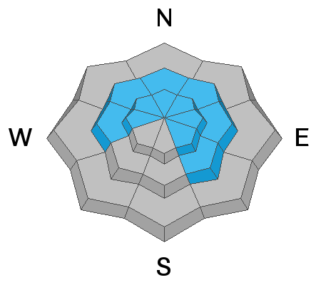
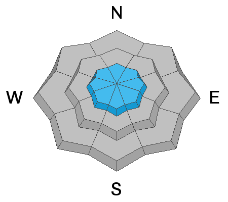
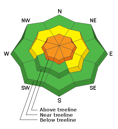
Today the avalanche danger above treeline is CONSIDERABLE. Small avalanches of wind drifted snow are likely. Very large avalanches may break near the ground. These large avalanches will be more difficult to trigger but their size makes the situation dangerous.

Near treeline, the danger is MODERATE where triggering a large avalanche remains possible but is a little less likely than it is in upper elevation terrain.

Below treeline the avalanche danger is LOW where avalanches are unlikely. Low danger does not mean "no danger". Avalanches can still happen which is why we always carry avalanche rescue gear and expose only one person at a time to avalanche terrain. To avoid avalanches completely, take advantage of all the terrain in the Uintas that is less than 30 degrees in steepness where avalanches don't happen.
Low
Moderate
Considerable
High
Extreme
Learn how to read the forecast here
Special Announcements
Watch this video from last Saturday's fatal avalanche near Preston, ID which includes video footage from the time of the accident. Read the preliminary report HERE.
Weather and Snow
Nowcast-
3-5 inches of light snow has fallen as of 5 a.m. Temperatures are mostly in the single digits F with upper elevations a few degrees below zero. Winds were blowing from the southwest overnight but this morning are blowing from the west 15 mph gusting 25-40 mph. At lower elevations, winds are a bit gusty.
Forecast-
Another 2-3 inches of snow should fall today. Temperatures will stay cold and remain in the single digits F. Fortunately winds should ease throughout the day eventually blowing from the NW tonight.
Futurecast-
Tomorrow will be sunny and cold with high temperatures only in the teens F. All of next week should be mostly sunny.

Looking for real-time temps, snow, or wind?
Click here and then on the "western Uinta" tab for western Uinta specific, weather station network.
Recent Avalanches
The last reported slides were some slabs of wind drifted snow seen on Thursday. Two larger slides happened on Tuesday in Upper Weber Canyon that Craig describes in the video below. The other large slide happened on Mt Marsell just north of Mirror Lake.

More obs, trip reports, and avalanches found here.
Ad
Avalanche Problem #1
Persistent Weak Layer
Type
Location
Likelihood
Size
Description
Throughout the Uinta Mountains, there is a slab 2-5 feet thick resting on a persistent weak layer (PWL) of facets about a foot above the ground. This PWL exists on most slopes except ones facing due south and southwest.
It's a tricky situation because it is low probability/high consequence. What we know is that if we trigger a slide, it can be 2-5 feet deep and hundreds or thousands of feet wide and deadly. Unfortunately, we don't know the exact probability of triggering an avalanche on this weak layer but it has gone down since snowfall about a week and a half ago. Today's snowfall may only raise the probability a small amount since it is only a few inches of light snow.
Another reason it is a tricky situation is that with such a supportable slab on top of this weak layer, a slope may have many sets of tracks on it and still slide if someone hits a thin spot in the snowpack. You can guess where those thin spots are but you never really know becuase they can be near a rock hidden under the snow.
What to do? Unfortunately it's just a season with a dangerous snowpack. There's no way around that fact, and I would avoid all big, open slopes steeper than 30 degrees. Slopes above treeline, especially with recent wind drifted snow, will be the most dangerous. Triggering a slide on slopes near treeline remains possible.
Avalanche Problem #2
Wind Drifted Snow
Type
Location
Likelihood
Size
Description
Winds have blown from nearly every direction this week. These winds have formed slabs of wind drifted snow on many different aspects mostly at upper elevations above treeline. Even though winds should slowly calm today, they will have no trouble drifting today's very low density snow.
These wind slabs can produce small avalanches on their own; however, they add weight and stress to weak, faceted snow near the ground. Areas with wind drifted snow are places more likely to produce large, deadly slides breaking near the ground.
Additional Information
We will update this forecast by 7:00 AM tomorrow, Sunday, February 28th.
Your observations are important, so please let me know what you're seeing... click HERE and contribute to this amazing community based program
General Announcements
If you see or trigger an avalanche or just wanna let me know what you're seeing you can reach me directly at 801-231-2170 or [email protected]
This forecast is from the U.S.D.A. Forest Service, which is solely responsible for its content. This forecast describes general avalanche conditions and local variations always occur.