Forecast for the Uintas Area Mountains

Craig Gordon
Issued by Craig Gordon on
Saturday morning, February 24, 2024
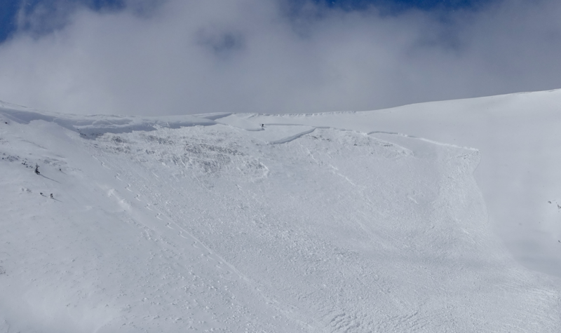
The walls aren't caving in... but multiple weak layers exist and avy danger remains tricky-
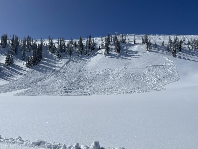
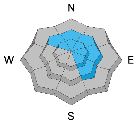
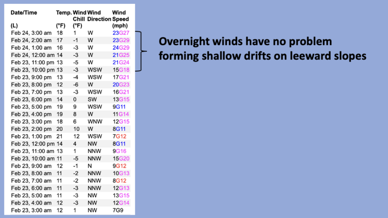
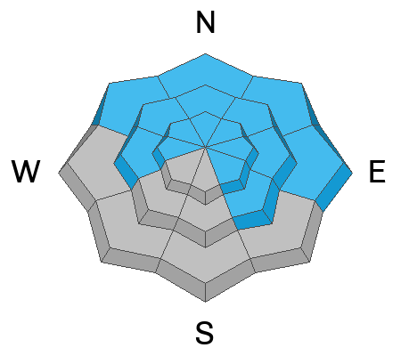
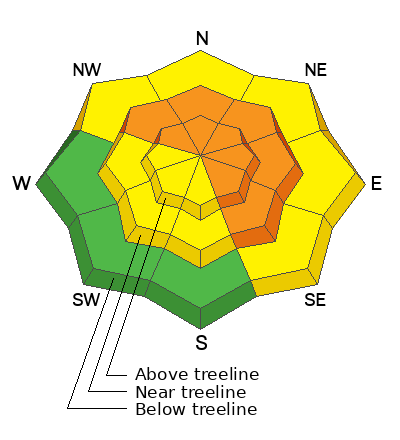
In mid and upper elevation terrain, you'll find pockets of CONSIDERABLE avalanche danger. While not widespread, human triggered avalanches are LIKELY, especially on steep, rocky, wind drifted slopes facing the north half of the compass. Any slide triggered has the potential to fail on weaker layers of snow, now buried several feet deep. Once initiated, today's avalanches can easily boss you around, will most definitely roll you, and in some cases deliver a season ending blow.
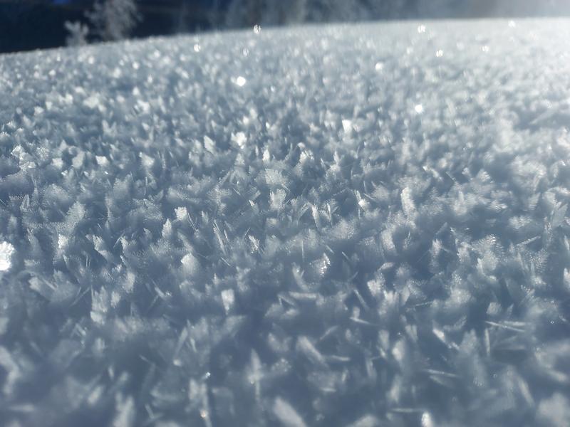
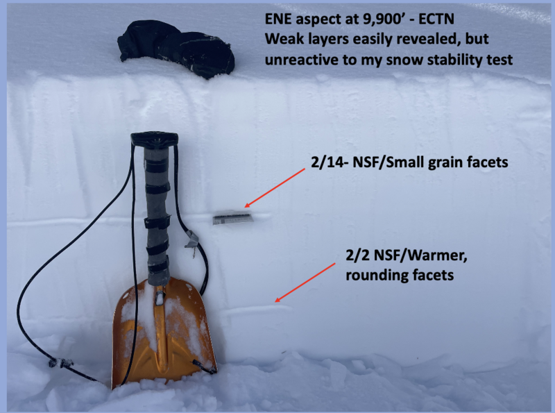
In addition, several weak layers varying in thickness, strength, and deceptive personality lurk in the snowpack. Lower elevation shady slopes, along with sunny aspects near and above treeline is where you'll encounter MODERATE avalanche danger and human triggered slides are POSSIBLE on steep slopes.

Here's your exit strategy-
You wanna avoid avalanches completely? Well, you came to the right place!
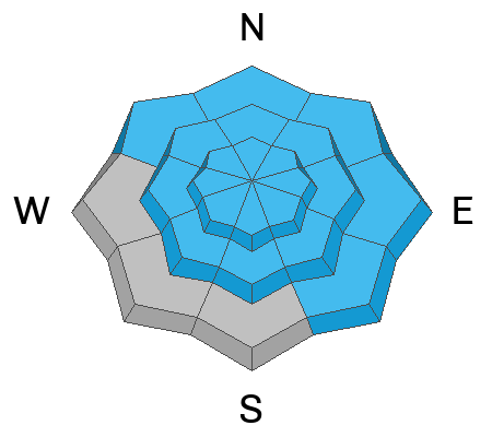
The Uintas have plenty of roly-poly, low elevation, low angle terrain, especially slopes facing the south half of the compass where you'll find LOW avalanche danger
Low
Moderate
Considerable
High
Extreme
Learn how to read the forecast here
Special Announcements
We are seeking a passionate individual to join us as Executive Director of the nonprofit Utah Avalanche Center. Click here for more information.
Also... please join the UAC and Inspired Summit Adventures for the grand opening of our new Transceiver Training Park at Pinebrook, Sunday, February 25, from 3:00-6:00PM.
Weather and Snow
Nowcast- A big, bright, beautiful Snow Moon looms large overhead while the mercury wraps up the graveyard shift in the mid teens. Winds blowing in the mid 20's from the west, began partying late Friday night and continue in that spirit early this morning. Low elevation snow took a hit from yesterday's strong February sun and most sunny slopes have a heat crust. But don't let your hearts be troubled... on a go-anywhere base, soft, settled snow is found on mid and upper elevation shady slopes.
Forecast- A glorious day is on tap as high pressure takes center stage, delivering nothing but blue skies and temperatures climbing into the mid and upper 30's. Near the high peaks, winds will be a little obnoxious but not too rowdy, blowing in the 20's from the west.
Futurecast- Sunday's high temperatures flirt with the records and Monday ushers in the warm before the storm. A strong cold front slides into the region Monday night into early Tuesday, with the south half of the range initially benefiting. The flow shifts to the northwest Tuesday with a solid shot of snow stacking up throughout the day. I think a foot of snow with nearly 1.5" water by closing bell seems like a good bet.
Our good friends and longtime partners at the City of Salt NWS lay out a timeline for the storm that kicks off the workweek.

Recent Avalanches
This avalanche in upper Moffit Basin was triggered by the sudden shock of a large cornice crashing onto the slope below. The northeast facing slope in the image above has avalanched several times this season... yup, it's a repeater.
We continue to see a deceptively tricky trend where most terrain is good to go. But steep, rocky, wind loaded slopes where, a thump in the right place or a cornice drop still triggers an avalanche that breaks to old layers of faceted snow near the ground has us steering clear of terrain with these characteristics.

Micheal J found spectacular surface hoar during his travels. MJ's trip report is found here.
I was in Upper Chalk Creek yesterday, stuck to moderately low to mid angle terrain, and found the snowpack very predictable.
For all Uinta observations and recent avalanche activity click HERE.
Ad
Avalanche Problem #1
Wind Drifted Snow
Type
Location
Likelihood
Size
Description
A 24 hour data dump from Windy Peak (10,662') illustrates recent trends with ridgetop winds.
After an unusually calm period for the western Uintas, westerly winds clocked in late last night, got down to business, and formed shallow drifts along the leeward side of upper elevation ridges. Easily managed with elevation and slope angle... lose the wind, lose the steepness, you lose the problem and score great riding conditions to boot!
Avalanche Problem #2
New Snow
Type
Location
Likelihood
Size
Description
Recent new snow stacks up on a variety of old snow surfaces and was quite reactive earlier this week. I saw encouraging signs yesterday that time and additonal insulating layers of snow are helping these layers adjust, but we wanna monitor this setup closely, especially with more snow, water, and wind on the way.
The new snow that piled up since early February is consolidating and may produce slab avalanches 1-3 feet deep. New snow slabs dot the landscape and will continue reacting to our additional weight today.
On shaded slopes, there is layer of buried surface hoar about 3 feet deep. It is not everywhere; however, Mark found it earlier this week in the Mill Hollow zone. We haven't gotten any reports of avalanches on this layer, but it's hard to ignore.
On sunny slopes, there is a thin layer of facets on top of a heat crust that was buried 12"-18" deep on Valentine's day. Recent avy activity has us considering it guilty until proven otherwise.
Avalanche Problem #3
Persistent Weak Layer
Type
Location
Likelihood
Size
Description
The slide in the image above checks all the boxes... steep, rocky, wind loaded, and a slope that has avalanched multiple times this season.
Even though the odds of triggering a monster avalanche have diminished, the consequences remain catastrophic. Common terrain theme and likely suspects are.... steep, rocky, north facing slopes with a thin, weak, snowpack and that includes slopes that have avalanched multiple times this year. You can trigger a deep, nasty slide from a thin portion of the snowpack like around a rock or bush, barely hidden under the snow.
Becoming more the exception of the rule, I wouldn't take my eyes of the prize... once triggered, these are season ending avalanches
Additional Information
The Uinta weather station network was upgraded this summer and all that real-time info is found HERE. Simply click on "western Uinta" tab and then "weather stations" tab.

We are always looking for snow and avalanche observations or just general riding conditions. So... if you see something, say something. You can reach me directly at [email protected] or 801-231-2170.
Also, if you're looking for more avy education opportunities for yourself, your crew, or your club please don't hesitate to reach out to me and we'll find a presentation, class, or clinic for ya!
General Announcements

Issued at 0400 on Saturday, February 24th this forecast will be updated by 0700 Sunday, February 25th, 2024.
This forecast is from the U.S.D.A. Forest Service, which is solely responsible for its content. This forecast describes general avalanche conditions and local variations always occur.