Forecast for the Uintas Area Mountains

Mark Staples
Issued by Mark Staples for
Sunday, February 25, 2024
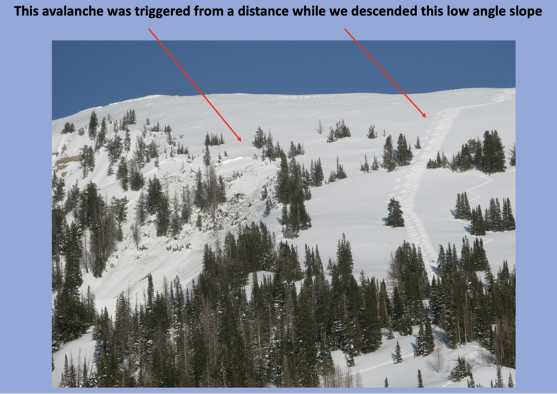
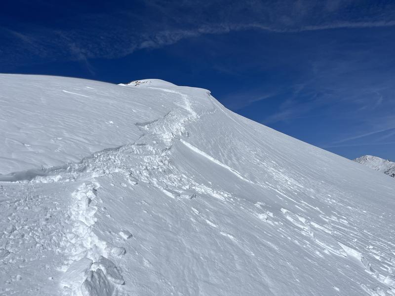
Today the avalanche danger is MODERATE, but don't let that yellow color fool you. This is the overall danger rating. Specific slopes will easily produce a deadly avalanche while others may have a deep strong snowpack. Read more below.
If you don't want to worry about avalanches, the Uintas are blessed with tons of mellow terrain less than 30 degrees in steepness where avalanches won't happen.
Low
Moderate
Considerable
High
Extreme
Learn how to read the forecast here
Special Announcements
We are seeking a passionate individual to join us as Executive Director of the nonprofit Utah Avalanche Center. Click here for more information.
TODAY - please join the UAC and Inspired Summit Adventures for the grand opening of our new Transceiver Training Park at Pinebrook, from 3:00-6:00PM. More info HERE.
Weather and Snow
This morning under clear skies, temperatures are mostly in the upper teens F and winds are blowing 15-20 mph at upper ridgelines from the WSW gusting to 25 mph.
Today will be similar to yesterday with sunny skies and temperatures warming into the mid 30s F. Winds will be blowing up to 20 mph at upper ridgelines.
The National Weather Service has issued a Winter Storm Warning from Monday morning until Tuesday night with 10-20 inches of snow expected. ALSO, Monday afternoon and evening should have very strong winds from the SW followed by very cold temperatures on Tuesday. A ridge of high pressure brings sunshine for Wednesday and Thursday, and then another storm may bring more snow later in the week.
SNOTEL sites in the Uintas, and much are Utah, report snow water equivalent amounts of 104%-146% of the 30 year median. Dry, cold powder and great riding remains on shady slopes, but the snow on any slope getting sunshine became damp yesterday and should have an ice crust on top this morning.
Recent Avalanches
This should get your attention - yesterday Craig and his group in upper Chalk Creek remotely triggered a large avalanche that broke to the ground, up to 10 feet deep and 350 feet wide. They triggered it about a hundred of feet away or more on low angle terrain.
For all Uinta observations and recent avalanche activity click HERE.
Ad
Avalanche Problem #1
Persistent Weak Layer
Type
Location
Likelihood
Size
Description
The odds of triggering an avalanche breaking near the ground on an old persistent weak layer are drastically different from one slope to the next. Many slopes have a deep and relatively strong snowpack where triggering one of these slides is unlikely. On other slopes, the odds are very high. In the case of Craig's avalanches yesterday, they didn't even have to get onto the slope to trigger it.
Chad and his partner were skiing in upper Weber Canyon where they described it as a "tale of two snowpacks". Most areas had deep snow until they walked onto a slope with just over 3 feet of total snow and they triggered the largest collapse they had every experienced with cracks shooting 150 feet from them (video below).
To avoid this problem, you'll have to be a detective to identity areas with thin snow. Notice the rocky area in the left side of the photo of Craig's avalanche. Steep rocky areas are often areas that may have a much thinner snowpack.
Avalanche Problem #2
Wind Drifted Snow
Type
Location
Likelihood
Size
Description
Winds from the west and southwest have transported some snow and formed shallow slabs of wind difted snow. Ted found a few yesterday on Lofty Lake Peak. These should be stabilizing, but you could trigger a few today.
Avalanche Problem #3
New Snow
Type
Location
Likelihood
Size
Description
New snow that has fallen since the start of February has settled into a slab about 1-3 feet thick. There are several weak layers under this new snow that could cause a slab avalanche. On shaded slopes, there is buried surface hoar about 3 feet deep. Even though I have found multiple times in multiple places, it hasn't produced avalanches but is still worth looking for. On sunny slopes, there is a thin layer of facets on top of a crust that was buried 12"-18" deep on Valentine's day. This layer last produced two avalanches in Mill Hollow on Tuesday and Wednesday. In American Fork Canyon on Thursdsay, this layer produced a huge avalanche.
Additional Information
The Uinta weather station network was upgraded this summer and all that real-time info is found HERE. Simply click on "western Uinta" tab and then "weather stations" tab.

We are always looking for snow and avalanche observations or just general riding conditions. So... if you see something, say something. You can reach me directly at [email protected] or 801-231-2170.
Also, if you're looking for more avy education opportunities for yourself, your crew, or your club please don't hesitate to reach out to me and we'll find a presentation, class, or clinic for ya!
General Announcements

Issued at 0700 on Sunday, February 25th this forecast will be updated by 0700 Monday, February 26th, 2024.
This forecast is from the U.S.D.A. Forest Service, which is solely responsible for its content. This forecast describes general avalanche conditions and local variations always occur.