UDOT PLANNED AVALANCHE CLOSURES!!

Forecast for the Uintas Area Mountains

Craig Gordon
Issued by Craig Gordon for
Tuesday, February 22, 2022
A MODERATE avalanche danger is found on all aspects above treeline. Human triggered avalanches are possible, especially in steep, wind drifted terrain facing the north half of the compass.
Lose the wind, you lose the problem, and you find LOW avalanche danger on mid and lower elevation slopes.
Low
Moderate
Considerable
High
Extreme
Learn how to read the forecast here
Weather and Snow
NOWCAST-
Happy palindrome Two's-Day :)
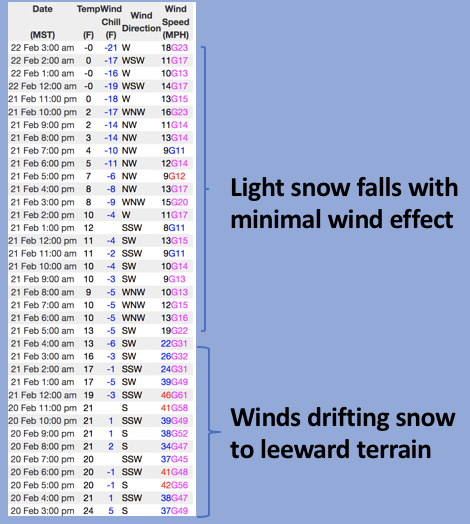
Yesterday's mini storm wasn't a region-wide barn burner, but it wasn't a bust either, delivering an inch or two at the trailheads and twice that amount with a little elevation gain. Clouds drape our mountains this morning and snow showers are just beginning to fill in again as another band of light snow creeps into the area. Westerly winds barely get anemometers spinning, blowing just 10-20 mph even near the high peaks. Temperatures cratered overnight and hover in the low single digits with a few stations dipping into negative territory early this morning. Riding and turning conditions continue to improve with each little shot of snow.
FORECAST-
Expect mostly cloudy skies with light snow showers through about mid morning. It'll be cold with high temperatures barely cracking into the low 20's. Westerly winds shouldn't get too out of hand, but they do bump into the upper 20's later in the day.
FUTURECAST-
Dang... it looks like the bulk of the next system in the storm queue dives into the central and southern portion of the state. We'll have to watch how the midweek storm plays out, it could bring snow wrecking east and northeast winds to our zone.
Trip reports and current state of the snowpack observations are found HERE.

Looking for real-time temps, snow, or wind?
Click HERE and then on the "western Uinta" tab for western Uinta specific, weather station network.
Recent Avalanches
Spencer was near Wolf Creek Pass Sunday and caught this viddy of a nimble footed rider not associated with his crew, trigger a fresh wind drift on a steep, northeast facing slope. The quick footed skier was able to get off the moving snow and everyone came home safely. Many thanks for the great info and for taking time to submit a very informative observation.... good on ya for helping out our community! More beta on this slide found HERE.
No other significant avalanche activity to report.

Your input is vital and we're interested in what you're seeing. Please contribute to this great community resource and go here to fill out an observation.
Ad
Avalanche Problem #1
Wind Drifted Snow
Type
Location
Likelihood
Size
Description
Above is a 36 hour data dump from Windy Peak (10,661') showing recent wind trends and timing for drifts to form on leeward slopes
While not particularly widespread, a few shallow wind drifts formed Sunday night, but are now camouflaged under yesterday's storm snow. Sounds deceptively complex, but we can keep things simple because the vast majority of fresh wind drifts are found on steep, leeward, upper elevation slopes, especially those in the wind zone facing the north half of the compass. So here's your exit strategy... lose the wind and you lose the problem. Yeah... simply lose some elevation and you find great riding with straight-forward avy danger. So, the key to riding safely today is to avoid fat rounded pillows of snow, especially if they appear chalky or sound hollow like a drum... done and done.
Additional Information
Your observations are important, so please let me know what you're seeing... click HERE and contribute to this amazing community based program
General Announcements
The information in this forecast expires 24 hours after the day and time posted, but will be updated by 07:00 Wednesday, February 23rd.
Before it gets too crazy, now is the time to book an avalanche awareness presentation for your group, club, or posse. You can reach me directly at 801-231-2170 or [email protected]
This forecast is from the U.S.D.A. Forest Service, which is solely responsible for its content. This forecast describes general avalanche conditions and local variations always occur.