Forecast for the Uintas Area Mountains

Craig Gordon
Issued by Craig Gordon for
Wednesday, February 23, 2022
A MODERATE avalanche danger is found on all aspects above treeline. Human triggered avalanches are possible, especially in steep, wind drifted terrain facing the north half of the compass.
Lose the wind, you lose the problem, and you find LOW avalanche danger on mid and lower elevation slopes.
Low
Moderate
Considerable
High
Extreme
Learn how to read the forecast here
Weather and Snow
NOWCAST-
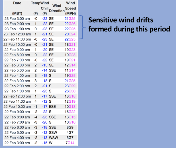
Light snow began falling late yesterday and continues early this morning as some backdoor moisture from a storm diving into central Utah trickles in from the southeast. This flow benefits the south half of the range where Currant Creek received 3" of low density snow, whilst the North Slope squeezes out just and inch or so. In either case, a layer of thick clouds drape our mountains and temperatures are winter-like, registering near zero degrees. Southeast winds blow in the mid 20's near the high peaks delivering finger-numbing windchill factors to -22 degrees. Riding and turning conditions continue to improve with each little shot of snow.
FORECAST-
Expect mostly cloudy skies with scattered snow showers throughout the day. 2"-4" stacking with slightly more on the southern end of the range up by days end seems like a good bet. It'll be cold with high temperatures barely cracking into the low 20's. East and southeast winds should remain reasonable, blowing in the 20's along the high ridges.
FUTURECAST-
Snow showers and cold temperatures linger into Thursday with high pressure and slowly warming temperatures on tap to round out the work week.
Trip reports and current state of the snowpack observations are found HERE.

Looking for real-time temps, snow, or wind?
Click HERE and then on the "western Uinta" tab for western Uinta specific, weather station network.
Recent Avalanches
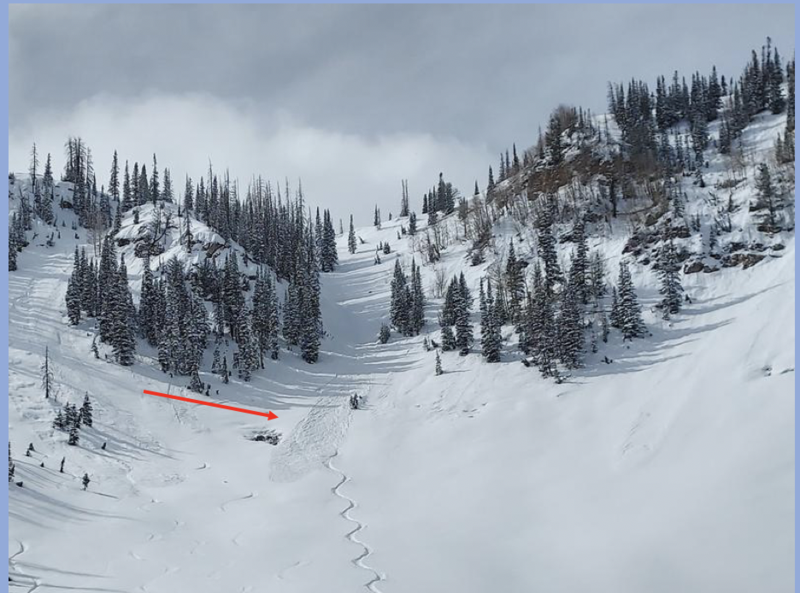
Micheal J was in the lower Weber Canyon drainage yesterday practicing his sluff management skills and says... "In steep north facing terrain the snow is easily sluffing but is manageable by just getting out of the way and letting the snow fly by." Michaels travels, insight, and trip report is found HERE
No other significant avalanche activity to report.

Your input is vital and we're interested in what you're seeing. Please contribute to this great community resource and go here to fill out an observation.
Ad
Avalanche Problem #1
Wind Drifted Snow
Type
Location
Likelihood
Size
Description
Above is a 24 hour data dump from Lofty Lake Peak (11,186') showing recent wind trends and timing for drifts to form on upper elevation leeward slopes
Recent winds blow from an unusual southeast direction and will load terrain we often see scoured by winds. But here's where the rubber hits the road... our low density storm snow is easily whipped into shallow drifts that'll react to our additional weight. As today's snow continues piling up, some drifts will get camouflaged under fresh snow, while others are easier to spot. Sounds deceptively complex, but we can keep things simple because the vast majority of today's avalanche problem is found on steep, leeward, upper elevation slopes, especially those in the wind zone facing the north half of the compass. So here's your exit strategy... lose the wind and you lose the problem. Yeah, simply lose some elevation and you find great riding with straight-forward avy danger. So, the key to riding safely today is to avoid fat rounded pillows of snow, especially if they appear chalky or sound hollow like a drum... done and done.
Additional Information
Your observations are important, so please let me know what you're seeing... click HERE and contribute to this amazing community based program
General Announcements
The information in this forecast expires 24 hours after the day and time posted, but will be updated by 07:00 Thursday, February 24th.
Before it gets too crazy, now is the time to book an avalanche awareness presentation for your group, club, or posse. You can reach me directly at 801-231-2170 or [email protected]
This forecast is from the U.S.D.A. Forest Service, which is solely responsible for its content. This forecast describes general avalanche conditions and local variations always occur.