Forecast for the Uintas Area Mountains

Craig Gordon
Issued by Craig Gordon for
Monday, February 21, 2022
HEADS UP... with an incoming storm, our recent string of green light avy conditions is rapidly changing.
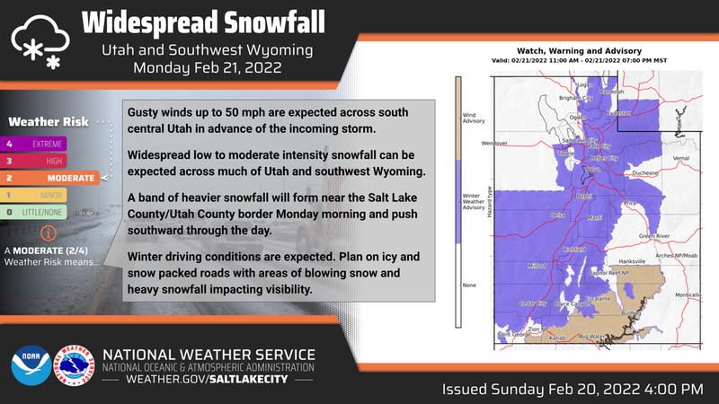
A MODERATE avalanche danger is found on all aspects at and above treeline, but especially in terrain facing the north half of the compass where storm snow stacks up on very weak pre-existing surface snow. Human triggered avalanches are possible, particularly on steep slopes offering a stronger snow on weaker snow combo.
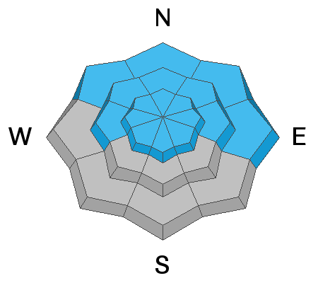
The south half of the compass at mid and lower elevations offers generally LOW avalanche danger.
No matter how we recreate on the snow today, as new snow piles up you'll want to be alert to changing weather conditions.
Low
Moderate
Considerable
High
Extreme
Learn how to read the forecast here
Weather and Snow
NOWCAST-
A storm is on our doorstep and overnight, a blanket of clouds settled in and enveloped our mountains. Rather mild temperatures register in the low to mid 20's. Southwest winds increased on Sunday and continued humming along in the 30's and 40's along the high ridges. Riding and turning conditions improved with last Wednesday's storm and more snow is on the way this week. Not exactly a full-on ear to ear grin, but Ullr is starting to smile down on us none-the-less.
FORECAST-
Snow develops in the next few hours and starts falling in earnest by mid morning... 4"-8" looks like a good bet by days end. In the meantime, southwest winds shift to the west and blow steadily in the 30's and 40's near the high peaks. We've already hit our high temperature for the day and the mercury begins falling into the teens and single digits overnight.
FUTURECAST-
Snow showers linger into Tuesday morning and another storm is on tap for late for in the day, though it looks like the bulk of the system dives into the central and southern portion of the state.
Trip reports and current state of the snowpack observations are found HERE.

Looking for real-time temps, snow, or wind?
Click HERE and then on the "western Uinta" tab for western Uinta specific, weather station network.
Recent Avalanches
Spencer was near Wolf Creek Pass yesterday and caught this viddy of a nimble footed rider not associated with his crew, trigger a fresh wind drift on a steep, northeast facing slope. The quick footed skier was able to get off the moving snow and everyone came home safely. Many thanks for the great info and for taking time to submit a very informative observation.... good on ya for helping out our community! More beta on this slide found HERE.
No other significant avalanche activity to report.

Your input is vital and we're interested in what you're seeing. Please contribute to this great community resource and go here to fill out an observation.
Ad
Avalanche Problem #1
New Snow
Type
Location
Likelihood
Size
Description
Sporting climbing skins as an alternate, fashion accessory, I describe the current snowpack setup in the viddy above.
Todays storm snow stacks up on a mixed bag of pre-existing snow surfaces and it's not a one-size-fits-all kinda avy danger. So you're gonna need to be on your toes and assess each slope on an individual basis because it's gonna be tricky today. The biggest red flag is... there's no shortage of very weak surface snow, especially in wind sheltered terrain facing the north half of the compass. And here's the problem... that's exactly the type of terrain we tend to migrate towards during time of elevated avalanche hazard. I know you're here for a solution and what I'd do is simply swing around to the south half of the compass where I know I'm dealing with new snow falling on a predictably firm, melt-freeze crust. Or if I'm looking for something softer underfoot and choosing terrain facing the north half of the compass, I'll avoid steep terrain and keep slopes angles super mellow and less than 30 degrees in steepness.
No matter how we recreate on the snow today, as new snow piles up, you'll want to be alert to changing weather conditions.
Avalanche Problem #2
Wind Drifted Snow
Type
Location
Likelihood
Size
Description
As today's storm materializes, fresh wind drifts will become more widespread, more reactive to our additional weight, and will break deeper and wider than we might expect. The key to riding safely today is to avoid fat rounded pillows of snow, especially if they appear chalky or sound hollow like a drum.
Additional Information
Your observations are important, so please let me know what you're seeing... click HERE and contribute to this amazing community based program
General Announcements
The information in this forecast expires 24 hours after the day and time posted, but will be updated by 07:00 Tuesday, February 22nd.
Before it gets too crazy, now is the time to book an avalanche awareness presentation for your group, club, or posse. You can reach me directly at 801-231-2170 or [email protected]
This forecast is from the U.S.D.A. Forest Service, which is solely responsible for its content. This forecast describes general avalanche conditions and local variations always occur.