March Kicks Off Our Spring Campaign- Donate Now to Support Forecasting

Forecast for the Uintas Area Mountains

Craig Gordon
Issued by Craig Gordon on
Sunday morning, February 20, 2022
HEADS UP... with an incoming storm, our recent string of ride it if it's white avy conditions change in the next 24 hours
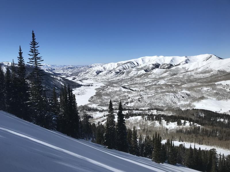
For today, LOW avalanche danger is found across the range and Green Light conditions blanket the danger rose, suggesting human triggered avalanches are unlikely on all aspects and elevations. While most terrain is good to go, be alert to changing weather conditions and warming temperatures as the day wares on, especially if you're stepping into a big, committing line where triggering even a small slide could have major consequences which instantly throw a curve ball your way.
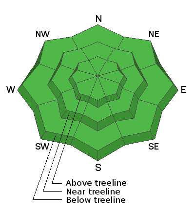
Low
Moderate
Considerable
High
Extreme
Learn how to read the forecast here
Weather and Snow
NOWCAST-
Skies are clear and temperatures slightly inverted, registering in the low to mid 20's near the ridges and teens at the trailheads. Southwest winds began blowing 20-30 mph along the high ridges right around dinnertime Saturday and continued in that spirit overnight. The mid week storm had its eye on the North Slope, delivering a 9" low density shot o' snow to that zone, whilst half that amount stacked up from Trial Lake southward. In either case, it's a great reset and a fresh coat of white paint awaits your arrival.
FORECAST-
The warm before the storm... after a sunny start, look for increasing clouds with southerly winds steadily blowing in the 30's near the high peaks. Temperatures climb into the upper 30's with overnight lows dipping into the 20's.
FUTURECAST-
The graphic above lays out the timeline for late Sunday through the beginning of the work week. Looks like a decent reset with 6"-8" of snow on tap for Monday/Tuesday.
Trip reports and current state of the snowpack observations are found HERE.

Looking for real-time temps, snow, or wind?
Click HERE and then on the "western Uinta" tab for western Uinta specific, weather station network.
Recent Avalanches
Ted and I found the low density storm snow easily sluffed on sustained, steep slopes. Ted noted how surprised he was that such a small slide stacked up an unusual amount of snow. Ted's insight and trip report is found HERE.
No other significant avalanche activity to report.

Your input is vital and we're interested in what you're seeing. Please contribute to this great community resource and go here to fill out an observation.
Ad
Avalanche Problem #1
Normal Caution
Type
Location
Likelihood
Size
Description
Sporting climbing skins as an alternate, fashion accessory, I describe the current snowpack setup in the viddy above.
  • Both Ted and I found the new snow reactive to our additional weight. In fact, on steep slopes facing the north half of the compass, the new snow is gouging into sugary, near surface facets, that grew weak during the January dryspell. While mostly manageable in size, today you'll want to avoid getting caught in sluffing snow that could carry you over a cliff or pile up deeper than you might expect on the uphill side of a tree or gully feature.
  • As the midweek storm exited the state, east and northeast winds blew in the 40's near the high ridges, whipping up drifts in unusual locations. Pockety in nature and found in the wind zone above treeline, today you'll wanna be on the lookout for look for and avoid any fat looking piece of snow, especially if it sounds hollow like a drum.
Additional Information
I know you came here for the snow... but the down canyon views weren't too tough to take either :)
Your observations are important, so please let me know what you're seeing... click HERE and contribute to this amazing community based program
General Announcements
The information in this forecast expires 24 hours after the day and time posted, but will be updated by 07:00 Monday, February 21st.
Before it gets too crazy, now is the time to book an avalanche awareness presentation for your group, club, or posse. You can reach me directly at 801-231-2170 or [email protected]
This forecast is from the U.S.D.A. Forest Service, which is solely responsible for its content. This forecast describes general avalanche conditions and local variations always occur.