Forecast for the Uintas Area Mountains

Craig Gordon
Issued by Craig Gordon for
Tuesday, February 21, 2023
A robust and rowdy winter storm settles into the region later today... changing the landscape and the avy hazard-
We start the day with MODERATE avalanche danger above treeline in the wind zone on steep, leeward slopes. Human triggered avalanches are POSSIBLE in steep terrain facing the north half of the compass, particularly slopes with an easterly component to their aspect. As the day wares on and snow stacks up, look for more widespread drifting with the avalanche danger bumping up a notch, perhaps reaching CONSIDERABLE with human triggered avalanches LIKELY by about sunset.

Low
Moderate
Considerable
High
Extreme
Learn how to read the forecast here
Weather and Snow
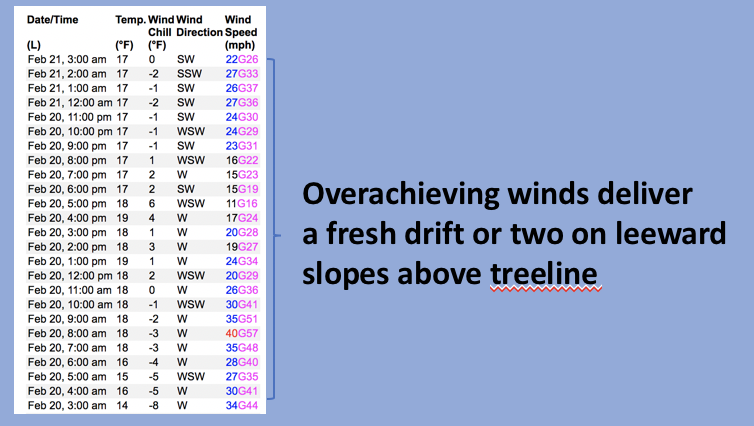
Nowcast- Clouds stream in from the northwest, temperatures register in the teens and low 20's, as west and southwest winds hum along in the 30's near the high peaks. Riding and turning conditions are still reeling from last weeks cow-tipping wind event and most of our big, open alpine terrain is wind jacked. However, don't let your hearts be troubled... swaths of very sheltered, low angle shady slopes offer smooth riding with a little cushion underfoot.
Forecast- Hang on to your hats, if you wear one, it's gonna be a wild ride... especially later today as a major winter storm is expected to slam into the eastern front. Look for thickening clouds with snow showers increasing in intensity later this morning. Temperatures rise into the upper 20's with west and southwest winds ramping into the 50's and 60's as the day progresses. A strong cold front crosses the area around dinnertime, the storm plugs into a stack of Marshall amps and goes fully electric, that'll of course usher in very intense snow rates.
Futurecast- Snow continues through the night, temperatures dip into the single digits, and westerly winds decrease somewhat, tapering into the 40's. Look for snow totals in the 12"-18" range for Wednesday morning with snow showers continuing through the day. A break is slated for Thursday with another storm hot on its heels to round out the workweek.
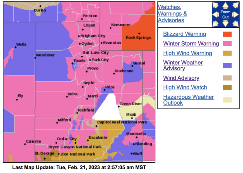
Ya gotta love the colors and you're probably grateful you switched this weeks stay at the Rock Springs timeshare... quite the meteorological Rorschach test.
Huge thanks for all the great obs streaming in from the eastern front. Even more detailed trip reports and recent obs are found HERE.
Recent Avalanches
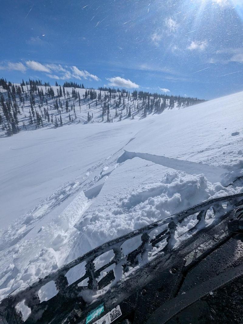
Sunday, Joey Manship and his crew found very shallow, yet sensitive, fresh drifts along the leeward side of upper elevation ridges.
No significant avalanche activity to report, but if ya wanna geek out, click HERE to track this years slide activity throughout the range.
Ad
Avalanche Problem #1
Wind Drifted Snow
Type
Location
Likelihood
Size
Description
Above is a 24 hour data dump from Windy Peak (10,662') showing trends in wind speed, direction, and duration.
Winds are gonna be burly and coupled with fresh snow create widespread and more connected wind drifts, especially later in the day once the storm gets underway. Remember.... strong winds deliver fresh drifts not only lower downslope than you might expect, but also cross-load terrain features like chutes and gullies. In either case, as the day wares on, look for and avoid fat, rounded pieces of snow, especially if they sound hollow like a drum.

Additional Information
Note to self... whilst not widespread, on Saturday, we found surprisingly weak, sugary Near Surface Facets forming on super sheltered, low and mid elevation polars. Could be a sleeper elevation band with the upcoming storms.
Weather stations-
And... rime events have severely crippled the Uinta weather station network. I'm working to get it back up and running, but a few stations are found HERE (click weather stations, and then on the Western Uinta tab)
Observations-
Your observations are important, so please let me know what you're seeing... click HERE and contribute to this amazing community-based program
General Announcements
Issued at 03:33 on Tuesday February 21st, this forecast expires 24 hours after the date and time posted, but will be updated by 07:00 Wednesday February 22nd 2023.
Before it gets too crazy, now is the time to book an avalanche awareness presentation for your group, club, or posse. You can reach Craig directly at 801-231-2170 or [email protected].

This forecast is from the U.S.D.A. Forest Service, which is solely responsible for its content. This forecast describes general avalanche conditions and local variations always occur.