Forecast for the Uintas Area Mountains

Craig Gordon
Issued by Craig Gordon on
Saturday morning, February 14, 2026

Heads up... a series of increasingly strong winter storms are poised to slam into the region this week, changing the landscape and ramping up the avy danger.

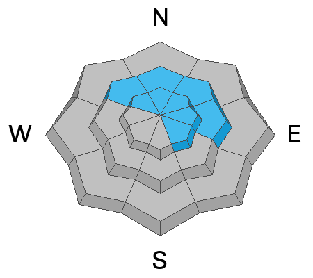
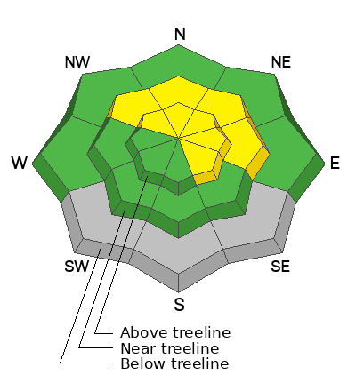
For today, at and above treeline, you'll find MODERATE avalanche danger in steep, polar terrain facing the north half of the compass. Human triggered avalanches breaking two feet deep and a hundred feet wide are POSSIBLE. Here's where it gets tricky... today's avalanches can be triggered from a distance and will fail on persistent weak layers formed during the January dry-spell, delivering a punch-packing slide that breaks deeper and wider than we might expect.

Here's my exit strategy... I'm gonna tag some low angle, Valentine's Day love in polar terrain with no overhead hazard :)
Low
Moderate
Considerable
High
Extreme
Learn how to read the forecast here
Special Announcements

Join the UAC for the first "Stay and Play Avalanche Course" at Bear River Lodge in the Uintas, March 19th-22nd. This course is designed for snowmobilers by snowmobilers, where you will learn avalanche rescue, riding skills, and how to survive in the backcountry. Come enjoy all the luxury offerings at Bear River Lodge and improve your skills along the way.

Weather and Snow

Nowcast - Skies cleared overnight and thermometers reflect a more winter-like vibe with temperatures beginning the day in the low teens °F. Winds blowing 15-20 mph from the northwest add a bite to the air near the high peaks. No new snow overnight, but the midweek storm stacked up a solid foot of snow with over an inch of H20, delivering superb riding conditions, especially on low angle, upper elevation polar slopes where there's less bottom feeding on old snow surfaces.

Forecast - Short-lived high pressure furnishes a stunning day of love and a rosy forecast. Look for mostly sunny skies with high temperatures climbing into the upper 30's °F. Winds blow 10-20 mph from the northwest and remain relatively well-behaved this morning, but ramp into the 30-40 mph range and switch to the southwest by about dinnertime. Clouds increase late in the day and overnight lows dip into the mid 20's °F.

Futurecast - Encouraging news... a much anticipated change in the weather appears to be more than just a hunch or a Ouija board notion. High pressure shifts to the east late Sunday, opening the storm door with several robust systems slated to slide through northern Utah this week. The first impulse begins churning into our region late Monday with strong southerly winds and a warm before the storm, followed by a well-defined cold front coupled with a solid slug of moisture. We're sorting through the deets and will have a better handle on timing and storm progression for tomorrow's update.

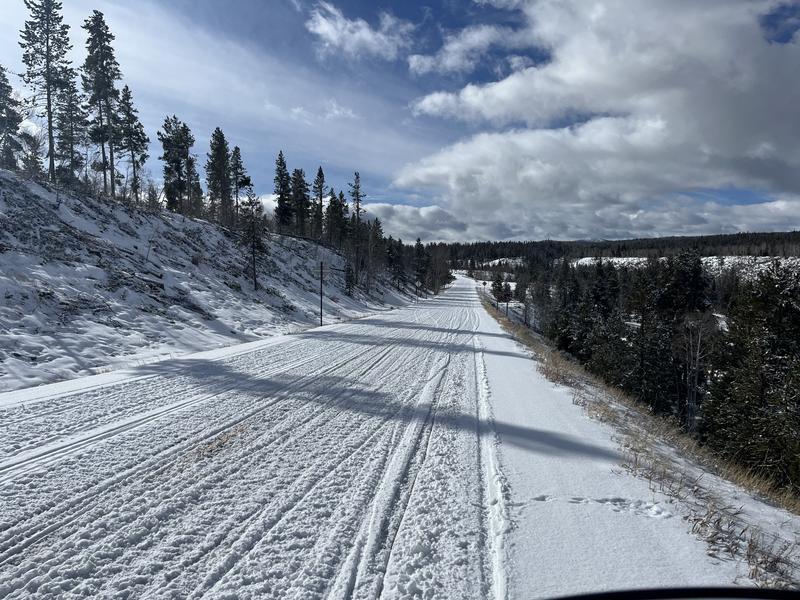
Travel Conditions - Please don't get discouraged by the mud and patches of bare ground at the trailheads. Gain a little elevation and you'll see the recent storms have delivered a nice coat of white paint to the high country.

Recent Avalanches

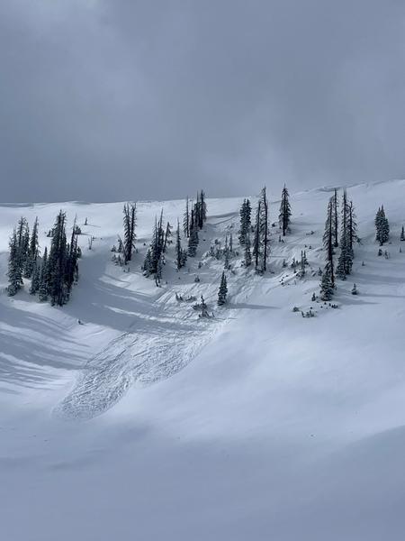
With a break in the weather yesterday, avy savvy, Weber Canyon local Trevor Katz, was able to get eyes on some steep, wind drifted, upper elevation terrain and reports a couple of natural avalanches in Upper Weber Canyon that fit the bill of shallow soft slabs failing on facets formed during the January dry spell.

If you're weak layer curious, be sure to check out this beautiful viddy, illustrating how snow crystals morph into structurally challenged grains.

Avalanche Problem #1
Persistent Weak Layer
Type
Location
Likelihood
Size
Description

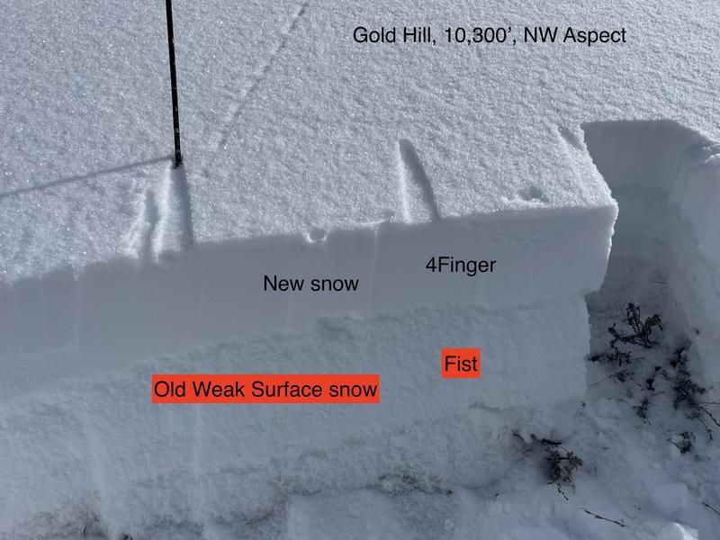
Local snow-pro Ted Scroggin was in the Gold Hill zone yesterday and reported no shortage or collapses and shooting cracks. Ted's insight definitely squares up given the snow structure he illustrated in the image above.

Several storms worth of snow along with wind drifts scattered in the alpine, now rest on top a persistent weak layer of near surface facets that grew large and grainy during the long stretch of dry January weather. The wheels of the bus aren't coming off just yet, but they are wobbling and all we need now is to stack a slab on top of this structurally challenged layer.

So here's where it gets tricky... as recent storm snow begins to settle and gain some body, it'll also gain some strength and morph into a more cohesive piece of snow or what we call a slab. This of course, is a natural process, but as the snow goes through changes it'll also get touchy and react to our additional weight. Once triggered, today's avalanches may break a bit deeper and wider than we might expect, packing a punch as they gouge into weak layers of snow, now buried just over a foot beneath the snow surface.

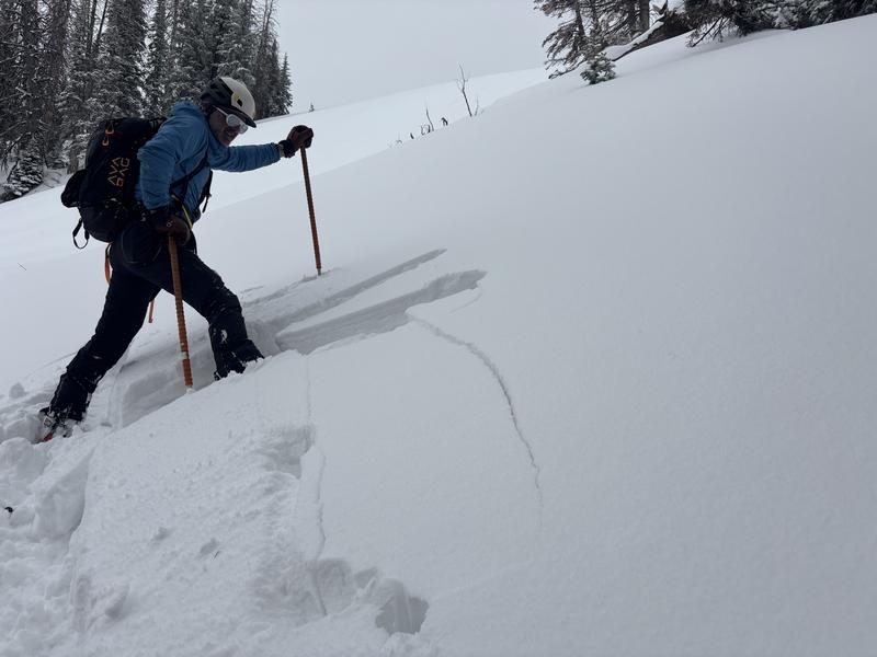
The snowpack came to life Thursday and definitely started talking. On my field day with John on the south half of the range, we experienced multiple collapses along with no shortage of shooting cracks in front of our skis like in the image above. Weston and Shaun were near Mirror Lake and report similar findings found HERE.

Additional Information

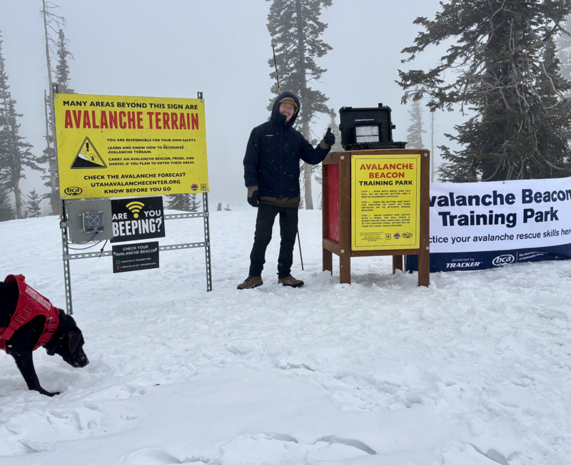
On Monday... Andy, Liam, and Juniper (the dog) installed a beacon training park near Wolf Creek Summit. It's super straight-forward and intuitive, and all the instructions are at the control center. Next time you see Liam or Andy, hit 'em up with a high-five for all the hard work. Truth be known... Juniper was only onboard because she thought the crew kept saying "bacon training park." So in lieu of a high-five, a back scratch or an Andy approved meat treat acknowledging Juniper's moral support will probably suffice :)

General Announcements

We have some upcoming classes and events that we'd be stoked to see you at -- Please reach out with any questions and check out below for more details!

We are always looking for snow and avalanche observations or just general riding conditions. Reach out to us with questions, concerns, or if you see anything in your travels! Contact us directly through the info below:

This forecast is from the U.S.D.A. Forest Service, which is solely responsible for its content. This forecast describes general avalanche conditions, and local variations always occur. This forecast was issued on Saturday, February 14th at 0300 and expires 24 hours after it was issued. We'll update this information by 07:00 AM tomorrow