Forecast for the Uintas Area Mountains

Craig Gordon
Issued by Craig Gordon for
Thursday, February 1, 2024
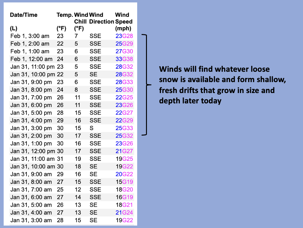
Expected storminess on the horizon delivers snow, water, and wind... anticipate a bump in the avy hazard as this system materializes.
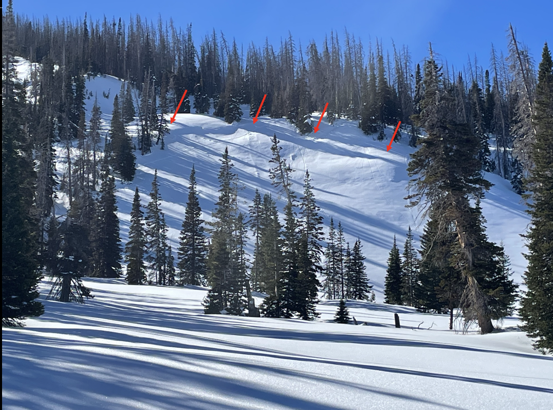
For today, look for the danger to rise to MODERATE as shallow wind drifts sensitive to our additional weight develop during the day. Timing is everything, but I bet human triggered avalanches are POSSIBLE on steep, leeward slopes by days end.
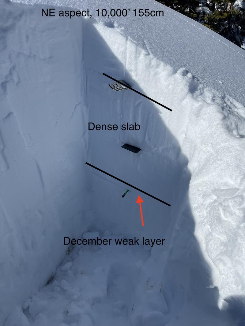
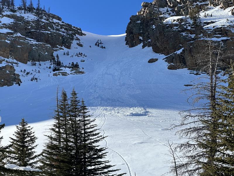
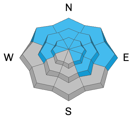
Becoming more the exception then the rule, let's not forget our problem child, the persistent weak layer that keeps MODERATE avalanche danger on our radar. Human triggered avalanches breaking deeper and wider than you might expect are still POSSIBLE, particularly on steep, rocky slopes facing the north half of the compass

Low
Moderate
Considerable
High
Extreme
Learn how to read the forecast here
Special Announcements
"Miraculously, I came out on top of the snow that day over 30 years ago. I knew I was lucky to be alive, and I never wanted to experience that again...And when the avalanche problem type is a persistent weak layer, I’ll never say the danger is “only” moderate."
Read an excellent blog by Moab Forecaster, Eric Trenbeath about a moderate danger with a persistent weak layer.
Weather and Snow
Nowcast- Hey winter, thanks for allowing me the late January tanning opportunity, but... "They say the darkest hour, is right before the storm.... but you wouldn't know it by me, everyday's been darker since you been gone." At o'dark thirty, high clouds begin streaming into the City of Salt as winds, blowing from the south and southeast, ramp up overnight and blow 25-35 mph near the high peaks. Temperatures are beginning to cool and register in the low to mid 20's.
Forecast- High pressure packed its bags and moved off to the east early this morning, opening the door to increasingly strong southerly winds, that'll blast into the 60's near the high ridges as the day wares on. Clouds thicken by mid morning and temperatures climb into the mid 30's. The south half of the range does alright with snow developing this afternoon and a few inches stacking up by dinnertime.
Futurecast- Colder air filters in overnight and that'll help enhance snowfall, especially for the North Slope. Friday brings a better chance of storminess and I'm cautiously optimistic storm totals stack up a foot of snow with an inch of water by early Saturday morning. A break in the action is slated for Sunday with more storminess on tap to kick off the work week.
Snow conditions - Warm temps and strong sunshine have had their way with many aspects, especially down low where the sunny slopes and hard and crusty. But gain some elevation, swing over to the north half of the compass and you'll be rewarded with soft, creamy snow on a go-anywhere base.
With decades of avy experience, all knowing snow-pro Ted Scroggin reports a surprisingly strong snow pack on the east side of the range. Tuesday, Ted was near Elizabeth Pass and has a great trip report found HERE.
Recent Avalanches
It's been downright hot the past few days and the snow surface feels the effect of a strengthening late winter sun. DJ Osborne spotted this damp slide yesterday that dribbled off a steep cliff band of Notch Mountain.

Read more Uinta observations and avalanches HERE.
Ad
Avalanche Problem #1
Persistent Weak Layer
Type
Location
Likelihood
Size
Description
I'm still cataloging the mid January avalanche cycle and found this rather large slide yesterday during my travels in Chalk Creek. I've been stepping out into bigger, steeper terrain, but I'm getting onto the slopes I know avalanched a few weeks ago.
You'd really have to go out of your way to trigger a slide that breaks to older layers of snow today, but shallow pow on a go-anywhere base, tends to steer us into bigger terrain, especially slopes in the wind zone. And while so much of the range avalanched during the mid January storm cycle, a few slopes remain intact, just waiting for us to roll along and tickle the right spot, and collapse the pack, often around a rock or bush barely hidden under the snow.
The good news is... the odds of triggering a slide on a persistent weak layer have decreased.
The less than ideal news is... it's not like lightning striking out of nowhere and it's not completely zero.
If you choose to enter avalanche terrain and ride steep slopes, stack the odds in your favor. Avoid areas of thinner snow near rocks (sometimes hard to do), make sure the runout zone is free of trauma-inducing trees and rocks, and make sure your partners watch you from a safe area.
Avalanche Problem #2
Wind Drifted Snow
Type
Location
Likelihood
Size
Description
An early morning data dump from Windy Peak (10,661') shows a steady increase in overnight winds.
As snow develops later this afternoon, expect the usual round of shallow drifts forming on the leeward side of upper elevation ridges and cross-loading around terrain features like chutes and gullies. By days end, I bet drifting becomes more widespread and reactive to our additional weight.
Additional Information
Most SNOTEL sites have about average water content and snow now. Below is a graph from the Trial Lake SNOTEL showing the 30 year median (green line) and this year's precipitation (black line).
The Uinta weather station network was upgraded this summer and all that real-time info is found HERE. Simply click on "western Uinta" tab and then "weather stations" tab.

We are always looking for snow and avalanche observations or just general riding conditions. So... if you see something, say something. You can reach me directly at [email protected] or 801-231-2170.
Also, if you're looking for more avy education opportunities for yourself, your crew, or your club please don't hesitate to reach out to me and we'll find a presentation, class, or clinic for ya!
General Announcements

Issued at 0400 on Thursday, February 1st this forecast will be updated by 0700 Friday, February 2nd, 2024.
This forecast is from the U.S.D.A. Forest Service, which is solely responsible for its content. This forecast describes general avalanche conditions and local variations always occur.