Forecast for the Uintas Area Mountains

Craig Gordon
Issued by Craig Gordon for
Friday, December 8, 2023
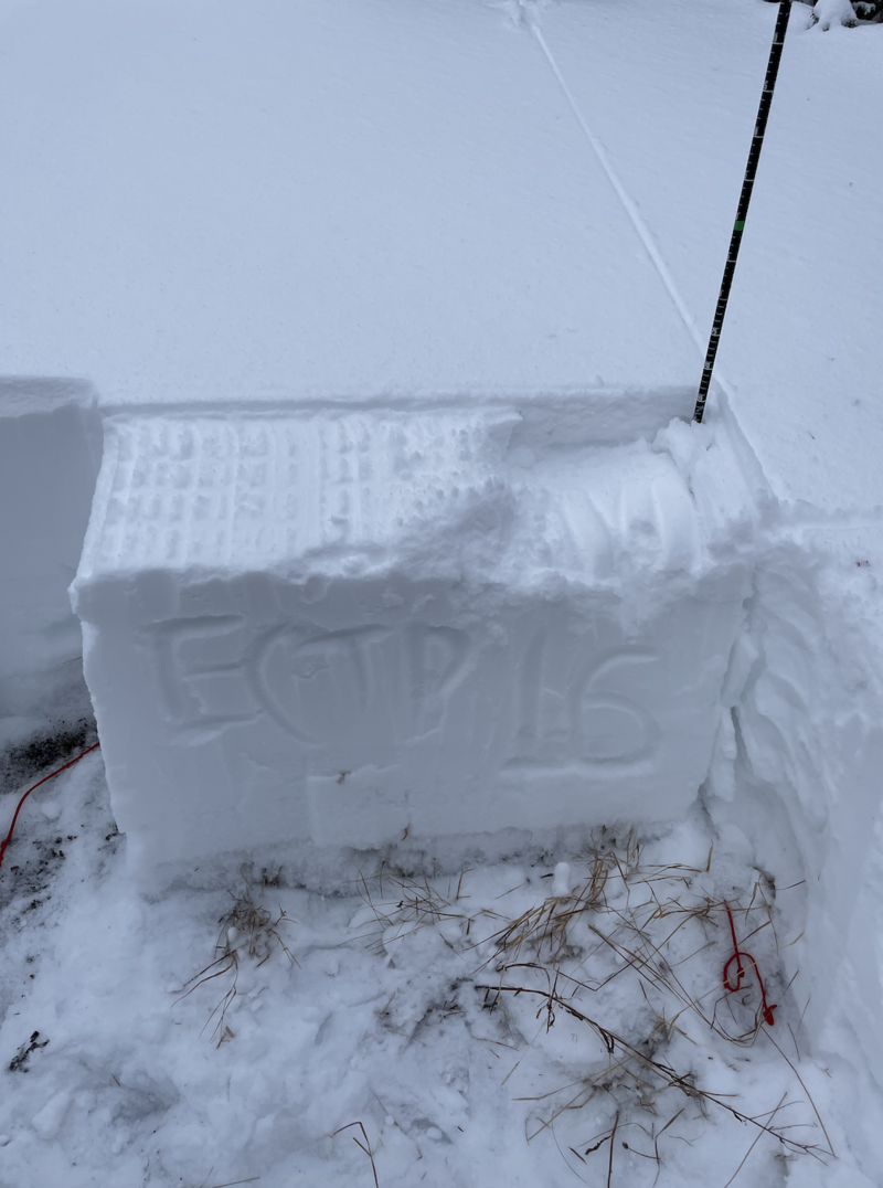
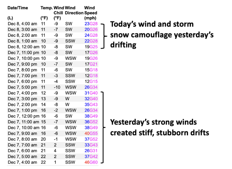
Heads up... the snowpack is getting thumped and avalanche danger is gonna get tricky-
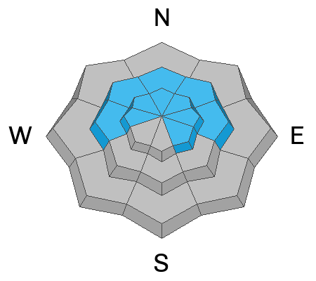
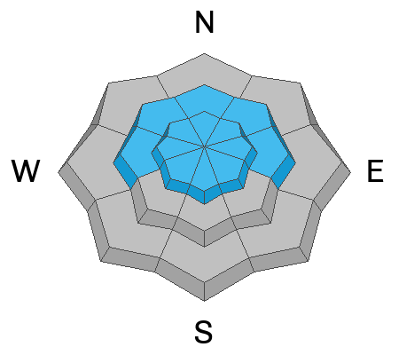
A materializing storm bumps the avy danger to CONSIDERABLE and human triggered avalanches are LIKELY, especially in the windzone at and above treeline. Today you'll want to avoid steep, leeward, upper elevation, wind drifted slopes, particularly those facing the north half of the compass. Know that any avalanche initiated in the new storm snow or fresh wind drift could easily break to weaker layers in the snowpack producing an avalanche that instantly gets out of hand.
It's a little more straight forward as you lose elevation but don't complacent and let your guard down. MODERATE avalanche danger is found on shady slopes and human triggered avalanches are POSSIBLE in steep, wind drifted terrain.

I know you're looking for good riding and more predictable avy danger... so-
Simply lose elevation, switch aspect and move over to sheltered slopes facing the south half of the compass and you'll find generally LOW avalanche danger.
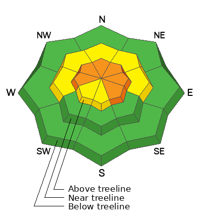
Low
Moderate
Considerable
High
Extreme
Learn how to read the forecast here
Special Announcements
The 5th Annual Avalanche Awareness Week is December 3-10. The week's goal is to save lives through activities that promote avalanche awareness, education, and safety.
We have a variety of events around the state. Find an event near you.
Weather and Snow
Nowcast- The powder party started a bit early yesterday and I got a little surprised that 4" of dense snow quickly stacked up by about mid day. This morning at o'dark thirty, yet another wave settles in and a nice shot of snow is headed our way. In fact, light snow currently falls under mostly cloudy skies as temperatures hover in the mid teens. Southerly winds took a brief break for supper last night, but began ramping up slightly at the turn of the new day and currently blow in the mid 20's near the high peaks. With just about 2' of settled snow the coverage is thin, but riding and turning conditions are slowly improving.
Forecast- A solid shot of snow is headed our way and the storm slides into our region around sunrise. The entire range gets a good dose of snow with storm totals in the 8" range, but it's a North Slope kinda storm and I'm thinking a solid foot of snow seems reasonable for that zone. As the storm gets going, winds shift to the northwest and blow in the 20's and 30's. Temperatures don't vary much from where we're at this morning, but crater into the single digits tonight.
Futurecast- Look for scattered snow showers lingering into Saturday morning.
Our good friends and partners at Salt Lakes National Weather Service issued a Winter Weather Advisory for the Uinta zone.
As of this morning, total settled snow depths around the range clock in at:

Recent Avalanches
No new avalanches reported yesterday, but a full list is available HERE

Trip reports and the latest observations are found HERE
Ad
Avalanche Problem #1
Persistent Weak Layer
Type
Location
Likelihood
Size
Description
Mark was in Shingle Mill Wednesday and found a structurally challenged snowpack.
Here's the windup and the pitch-
The bad news is... the snowpack has issues and weak, sugary basal snow or what we call a Persistent Weak Layer (PWL) is our current problem child. Remember... anything "persistent" in the snowpack takes time to heal and strengthen. The badder news is... until the pack becomes deeper and more robust the weak snow is here to haunt us for a while. And just as important and especially as the snowpack remains thin, the PWL is gonna roar back to life with each additional load of new snow, water, or wind. In fact, with just a little bit of dense, heavy snow stacking up yesterday, Trevor and his crew stomping around in Mill Hollow noted... "several rolling thunder-like propagating collapses could be heard underfoot, and across connected terrain. Some seemed to last the better part of a second." That tells me there's strong snow on weak snow and that's a dangerous combo in our mountains. With more storminess on the way today we're beginning to tip the scales.
Avalanche Problem #2
Wind Drifted Snow
Type
Location
Likelihood
Size
Description
This 24 hour data dump from Windy Peak (10,662') clearly illustrates recent variations in wind speed and duration.
New snow coupled with strong winds camouflages yesterday's wind drifts and they'll be hard to detect under today's storm snow. But here's the deal... found mostly on the leeward side of upper elevation ridges, I'd also steer clear of terrain features like chutes and gullies as well. Let's keep it simple... today, let's just avoid any fat, rounded piece of snow, especially if it sounds hollow like a drum. Or... lose some elevation, head to wind sheltered terrain and we'll lose the problem.
Additional Information
We are always looking for snow and avalanche observations or just general riding conditions. So... if you see something, say something. You can reach me directly at [email protected] or 801-231-2170.
Also, if you're looking for more avy education opportunities for yourself, your crew, or your club please don't hesitate to reach out to me and we'll find a presentation, class, or clinic for ya!
General Announcements

Issued at 04:30 on Friday, December 8th this forecast will be updated by 0700 Saturday, December 9th, 2023.
This forecast is from the U.S.D.A. Forest Service, which is solely responsible for its content. This forecast describes general avalanche conditions and local variations always occur.