Forecast for the Uintas Area Mountains

Craig Gordon
Issued by Craig Gordon for
Saturday, December 9, 2023
Heads up... the recent storm thumped our snowpack and avalanche danger is deceptively tricky-
Yesterdays big storm delivered a one-two punch... an abundance of fresh snow, coupled with strong winds. The snowpack is reeling, it's on the ropes, and we need to be patient and give the pack some time to adjust.
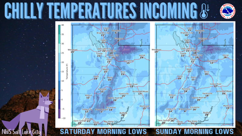
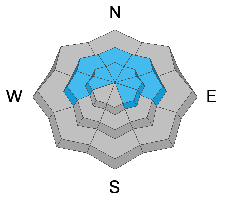
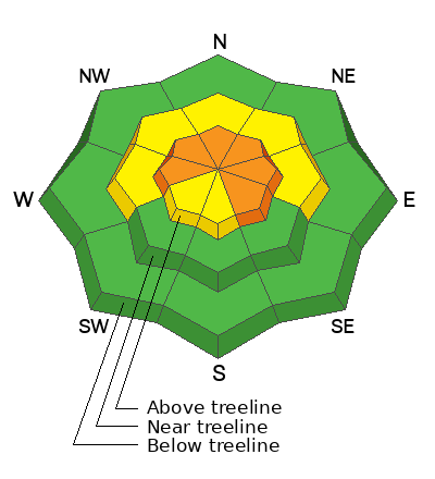
CONSIDERABLE avalanche danger exists and human triggered avalanches are LIKELY, especially in the windzone at and above treeline. Avoid steep, upper elevation, leeward, wind drifted slopes... particularly those facing the north half of the compass. Know that any avalanche initiated in the new storm snow or fresh wind drift could easily break to weaker layers in the snowpack producing an avalanche that instantly gets out of hand.
It's a little more straight forward as you lose elevation but don't get complacent and let your guard down. MODERATE avalanche danger is found on mid elevation shady slopes and human triggered avalanches are POSSIBLE in steep, wind drifted terrain.

Your exit strategy-
Lower elevation slopes facing the south half of the compass harbor no old snow and you'll find generally LOW avalanche danger.
Low
Moderate
Considerable
High
Extreme
Learn how to read the forecast here
Special Announcements
The 5th Annual Avalanche Awareness Week is December 3-10. The week's goal is to save lives through activities that promote avalanche awareness, education, and safety.
We have a variety of events around the state. Find an event near you.
Weather and Snow
Nowcast- Wow... what a great storm for the eastern front, particularly the North Slope which got buried with over 15" of snow and an inch of water weight. Yeah... blower pow! Just half that amount stacked up on the south half of the range. In either case, it's over-the-hood and over-the-head :)
Skies are clearing in the wake of the big storm, but a few snow showers linger. North and northwest winds blow15-25 mph along the high peaks and temperatures hover in the teens and single digits.
Forecast- It's shaping up to be a stunning, yet very cold day in the mountains. Look for partly cloudy skies with high temperatures barely crawling out of the teens. Northwest winds blow in the 20's along the high peaks, though a weak storm bumps winds into the 30's overnight.
Futurecast- Expect high clouds and perhaps a flurry or two for Sunday and Monday, but these are mostly underwhelming, dry weather systems.
A graphic illustrating expected cold temps from our good friends and partners at Salt Lakes National Weather Service.
With only 3' of settled snow the coverage is thin, but riding and turning conditions are rapidly improving.

Recent Avalanches
Visibility has been less than ideal and we haven't seen or heard of any recent avy activity. But a full list of recent slides is available HERE

Trip reports and the latest observations are found HERE.
Ad
Avalanche Problem #1
Persistent Weak Layer
Type
Location
Likelihood
Size
Description
Mark was in Shingle Mill Wednesday and found structurally challenged layers and that was before the big storm walloped our snowpack!
Here's the windup and the pitch-
Yesterday's big storm has our problem child, the sugary, persistent weak layer (PWL) teetering on the balance beam. What's gonna make today tricky is... you can ride plenty of low and mid elevation slopes without incident, but head to the high country and it's a different story. Upper elevation slopes that harbor weak, early season snow, particularly those facing the north half of the compass are just waiting for a trigger like us to roll along and knock the legs out from underneath. Any slide that fails on old snow is gonna break deep and wide and it's gonna be dangerous.
Remember... anything "persistent" in the snowpack takes time to heal and strengthen. Until the pack becomes deeper and more robust the weak snow is here to haunt us for awhile.
Avalanche Problem #2
Wind Drifted Snow
Type
Location
Likelihood
Size
Description
Above is a 24 hour data dump from Windy Peak (10,662') clearly illustrating recent variations in wind speed and duration.
New snow coupled with strong winds camouflages yesterday's wind drifts and they'll be hard to detect under today's storm snow. But here's the deal... found mostly on the leeward side of upper elevation ridges, I'd also steer clear of terrain features like chutes and gullies as well. Let's keep it simple... today, let's just avoid any fat, rounded piece of snow, especially if it sounds hollow like a drum. Or... lose some elevation, head to wind sheltered terrain and we'll lose the problem.
Additional Information
We are always looking for snow and avalanche observations or just general riding conditions. So... if you see something, say something. You can reach me directly at [email protected] or 801-231-2170.
Also, if you're looking for more avy education opportunities for yourself, your crew, or your club please don't hesitate to reach out to me and we'll find a presentation, class, or clinic for ya!
General Announcements

Issued at 04:30 on Saturday, December 9th this forecast will be updated by 0700 Sunday, December 10th, 2023.
This forecast is from the U.S.D.A. Forest Service, which is solely responsible for its content. This forecast describes general avalanche conditions and local variations always occur.