Forecast for the Uintas Area Mountains

Craig Gordon
Issued by Craig Gordon for
Thursday, December 7, 2023
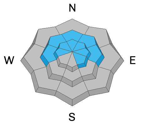
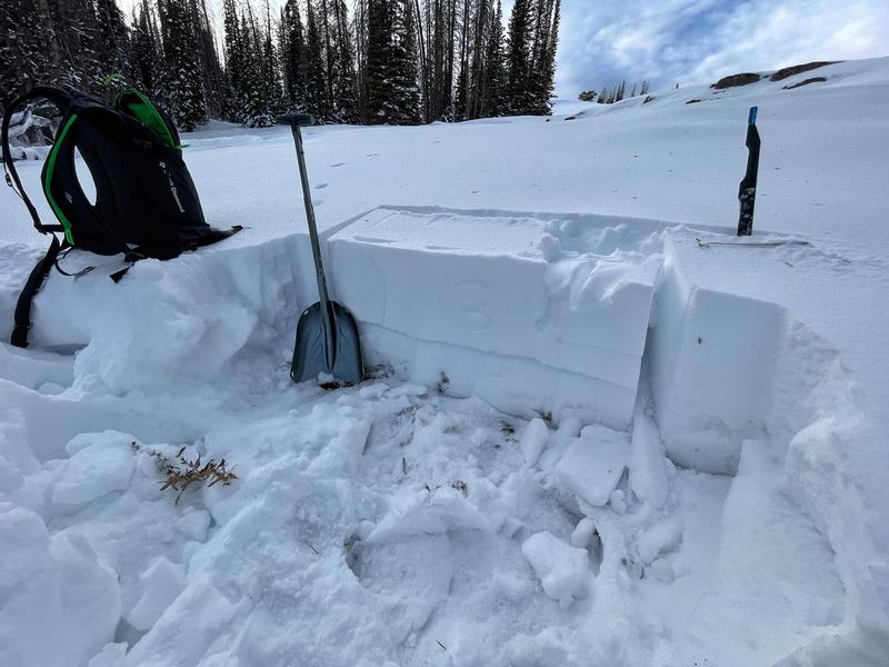
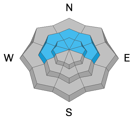
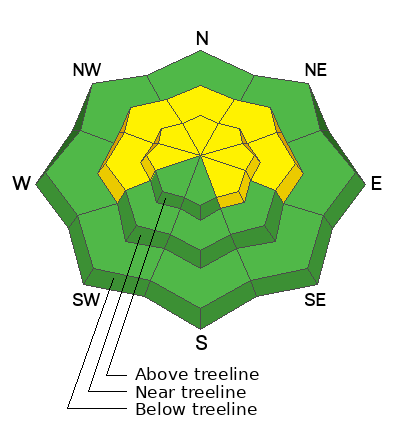
Today, in the windzone at and above treeline you'll find MODERATE avalanche danger and human triggered avalanches are POSSIBLE. However, the snowpack offers two distinctly different types of avalanche dragon with two distinctly different characteristics. The most obvious avy dragon are the wind stiff slabs forming on steep, leeward slopes which crack out in front of us and break within the freshly drifted snow. The second not-so-obvious, harder to trigger, and more dangerous avalanche dragon fails on the persistent weak layer (PWL) formed in November, producing an avalanche that breaks deeper and wider than you might expect. That kind of avalanche dragon instantly gets out of hand and instantly ruins our day!

So here's how we manage the unmanageable-
Simply lose elevation, switch aspect and move over to slopes facing the south half of the compass and you'll find generally LOW avalanche danger.
Low
Moderate
Considerable
High
Extreme
Learn how to read the forecast here
Special Announcements
The 5th Annual Avalanche Awareness Week is December 3-10. The week's goal is to save lives through activities that promote avalanche awareness, education, and safety.
I personally invite you to join me 6:00 tonight at the Young Powersports XL Super Center in Centerville. We'll be talking about avy basics and rescue, as well as current conditions.
We have a variety of events around the state. Find an event near you.
Weather and Snow
Nowcast- This day in rock n' roll history Otis Redding records (Sittin' On) The Dock of the Bay... whilst cloudy skies, temperatures in the low to mid 30's, and ridgetop southerly winds blowing in the 50's and 60's greet this day in western Uinta weather history.
Forecast- A storm sliding to our north produces mostly cloudy skies, strong southerly winds, and light snow showers later in the day. Temperatures cool into the high 20's and winds decrease as the day wares on. Snow totals are nothing to get too excited over, but a couple inches by late afternoon seems reasonable.
Futurecast- A stronger storm settles in overnight and delivers colder air and lighter winds. I'm cautiously optimistic for storm totals registering in the 12" range by Saturday morning.
Total settled snow depths are:

Recent Avalanches
No new avalanches reported yesterday, but a full list is available HERE

Trip reports and the latest observations are found HERE
Ad
Avalanche Problem #1
Persistent Weak Layer
Type
Location
Likelihood
Size
Description
Here's the setup-
During the late autumn dry spell, old snow from November grew weak and faceted (sugary) on shady slopes near and above treeline. And while not nearly as widespread or uniform, it may also exist below treeline, but it's definitely more pockety. Bust your shovel out and dig down... it's easy to see in any snowpit, just like in the image below. And while the big weekend storm delivered a much needed dose of dense heavy, base building snow, it also created a layer of cohesive snow (slab) on top of this PWL (persistent weak layer).
Mark was in Shingle Mill yesterday and found similar snow structure during his travels on shady slopes.
The snowpack is slowly adjusting to the big weekend storm and not nearly as reactive as earlier in the week. In fact, the past few days have been quiet and we haven't heard any loud, audible collapses or whoomping sounds and haven't seen any recent avalanche activity. However, it's still early in the game and I'm gonna continue to tread lightly, visit more terrain, and gather more intel, so I can develop a more clear pattern and lay of the land.
Avalanche Problem #2
Wind Drifted Snow
Type
Location
Likelihood
Size
Description
This 24 hour data dump from Windy Peak (10,662') clearly illustrates the uptick of southerly winds, especially early this morning.
There's not an abundance of snow available for transport, but winds have a curious way of channeling through terrain features and finding enough lose snow to blow around and form drifts in both the usual and not so usual locations. Let's keep it simple... today, you'll wanna avoid any fat, rounded piece of snow, especially if it sounds hollow like a drum.
Additional Information
We are always looking for snow and avalanche observations or just general riding conditions. So... if you see something, say something. You can reach me directly at [email protected] or 801-231-2170.
Also, if you're looking for more avy education opportunities for yourself, your crew, or your club please don't hesitate to reach out to me and we'll find a presentation, class, or clinic for ya!
General Announcements

Issued at 04:15 on Thursday, December 7th this forecast will be updated by 0700 Friday, December 8th, 2023.
This forecast is from the U.S.D.A. Forest Service, which is solely responsible for its content. This forecast describes general avalanche conditions and local variations always occur.