Check Out Our Holiday Auction!

Forecast for the Uintas Area Mountains

Craig Gordon
Issued by Craig Gordon on
Wednesday morning, December 3, 2025

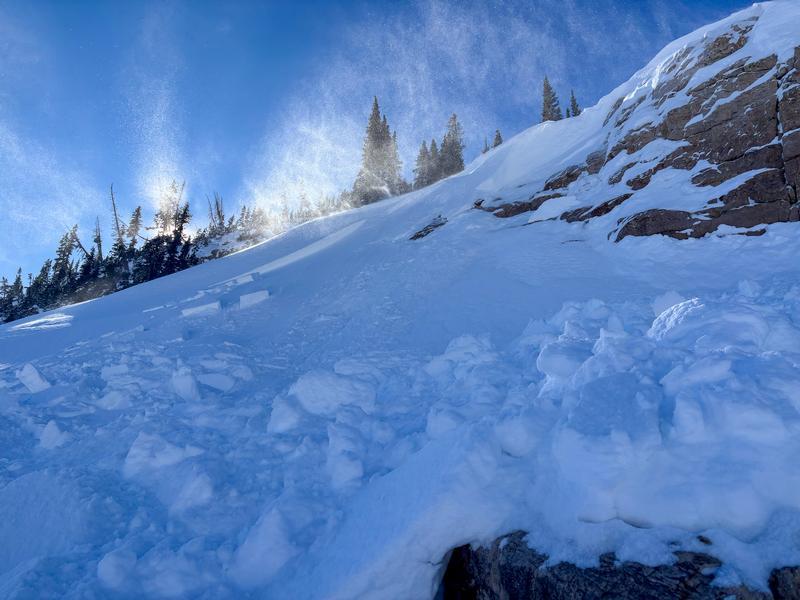
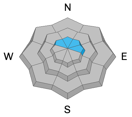
Pockets of MODERATE avalanche danger dot the landscape above treeline and human triggered avalanches are POSSIBLE, especially in the windzone on steep, drifted slopes facing the north half of the compass.

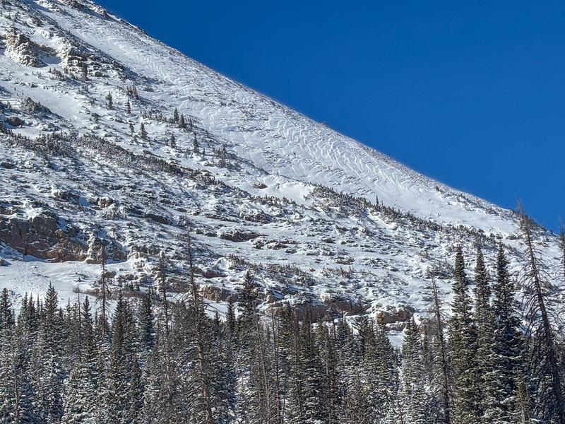
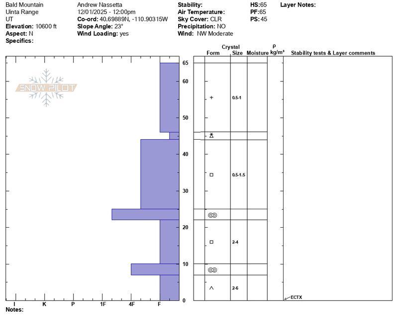
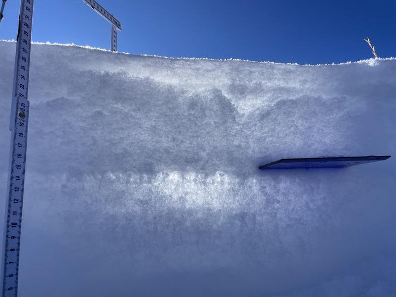
Closer to treeline it's a double edged sword... the avalanche danger is generally LOW, but where's it's white it's super weak underneath Sunday night's storm snow, and even a seemingly insignificant sluff could knock you off your feet.

It's extremely thin out there and our snowpack is weak, so I gotta remember... once triggered, today's slides will break deeper and wider that I might expect and even a small piece of snow will pack a powerful, season ending punch.
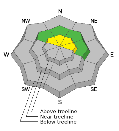
Low
Moderate
Considerable
High
Extreme
Learn how to read the forecast here
Special Announcements

Avalanche Awareness Week- Events are happening daily across the state to prepare you for winter and get you thinking about avalanche safety. Find out about all our events HERE. And don't forget the Utah Snow and Avalanche Workshop is Saturday, December 6 with in person and virtual options!

But wait... there's more!

Weather and Snow

Nowcast- Well that storm was a bust! Yup, yesterday's 2" of snow with .10"H20 is hardly even a rounding error on a spreadsheet, but with a lean start to the season, we'll take what we can get. A lingering snow shower or two slides by the region early this morning and temperatures register in the teens. Near the high peaks there's hardly a breath of wind as northeasterlies blow just 5-10 mph. It's thin out there, but reasonable travel conditions are found on snow covered roads and rock free meadows.

Forecast- Look for mostly cloudy skies this morning with a lingering snow shower or two, but in general we're drying out and should see sunny skies as the day progresses. Bumping into the teens and low 20's, northerly winds remain rather well-behaved today. Temperatures climb into the mid and upper 20's and dip into the low teens overnight.

Futurecast - A break in the action is slated for Thursday and then it gets interesting to round out the work week. Our next storm moves into the region early Friday morning as the two sexiest words in meteorology (atmospheric river) sets up across the Pacific Northwest. Unlike the past couple systems, this storm has the potential to deliver a couple inches of water and a few feet of snow. We'll have a better idea of timing and strength in the next day or two.

Recent Avalanches

On Monday, Andy eye-spied this shallow pocket releasing on Bald Mountain during a late morning spike in wind speed.

Avalanche Problem #1
Wind Drifted Snow
Type
Location
Likelihood
Size
Description

In the alpine you can run, but ya can't hide. Bald Mountain got torched by recent winds. Andy noted... "the textured surface on the ridge where wind-drifted snow has been deposited on the leeward side of the slope.

Sunday's storm snow conspired with recent winds, forming dense drifts that'll react to our additional weight. The good news is... the hazard is pretty straight-forward and confined to steep, shady, upper elevation terrain, especially slopes that harbor early season snow. The bad news... those are the exact slopes we'll be lured into today because that's where the best coverage is found. But here's the problem... any slide triggered is gonna fail on snow that grew weak and sugary during the November dryspell and that means today's avalanches will break a little deeper and wider than you might expect. The badder news... even a relatively small slide will reveal a myriad of season ending obstacles like stumps and rocks, barely hidden underneath the thin veneer of an early season snowpack.

It'll be a glorious day in the mountains, so get out an enjoy the fresh snow! It's a great time of the season to stretch out the legs on a low angle meadows or take the sled for a quick road rip. And while you're out and about do a little snowpack CSI, dig a snowpit to see what we're dealing with, and map out the lay of the land. We know winter will eventually return from its hiatus, so a little homework now will give you a better sense for the type of terrain you can ride safely once it does start storming again.

Andy was in the Bald Mountain/Reids Peak zone Monday and has an awesome video update HERE.

Additional Information

Pit profile above is from Andy's travels Monday around Bald Mountain and Reid's Peak.

Meanwhile, Trevor and Jeremy found a much different snowpack structure with buried surface hoar in Upper Weber Canyon. They also commented... "cracking observed on buried surface hoar layer." A layer to keep an eye on as we move forward with winter.

General Announcements

We are always looking for snow and avalanche observations or just general riding conditions. Reach out to us with questions, concerns, or if you see anything in your travels! Contact us directly through the info below:

This forecast is from the U.S.D.A. Forest Service, which is solely responsible for its content. This forecast describes general avalanche conditions, and local variations always occur. This forecast was issued on Wednesday, December `3rd at 04:00 AM and expires 24 hours after it was issued. Andy will update this information by 07:00 tomorrow.