Forecast for the Uintas Area Mountains

Craig Gordon
Issued by Craig Gordon on
Wednesday morning, December 10, 2025

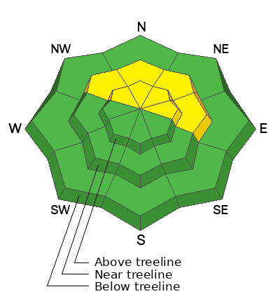
Today you'll find MODERATE avalanche danger at and above treeline on upper elevation slopes facing northwest through east. Human-triggered avalanches breaking several feet deep, failing on weak snow near the ground are POSSIBLE. Bullseye terrain- steep, rocky, leeward slopes, especially in the windzone where dense, hard wind-drifts rest on top of weak, faceted snow.

My strategy is avalanche avoidance... yeah, I’m sticking to low angle, wind sheltered, upper-elevation, sunny slopes, where I can find acceptable coverage, reduced avalanche danger, and work on my winter tan to boot.

Low
Moderate
Considerable
High
Extreme
Learn how to read the forecast here
Weather and Snow

Nowcast- Yesterday's trailing wave of moisture delivered a trace... perhaps a couple traces of snow in favored terrain across the range. High, thin clouds drift in and out of the region as storminess stays well to our north with its sights set on upstate New York. No worries if you forgot to plug the block heater in last night, it's mild this morning with trailhead temperatures registering in the low 30's (F), while the ridges feel a bit more winter-esque and in the mid 20's (F). Winds blowing 30-40 mph from west and southwest deliver a little bite near the high peaks. The snow surface is hit or miss, but swaths of soft, creamy snow in wind sheltered terrain await your arrival.

Forecast- Partly cloudy skies deliver a passing snow shower or two, otherwise clouds thin out as the day progresses. Winds blowing in the 40's from the west are gonna be obnoxious this morning, but should taper off by about dinnertime. High temperatures climb into the mid and upper 30's (F) and hover near freezing overnight.

Futurecast - We wrap up the workweek, high, dry, and warm. Setting a low-bar here, but there's a glimmer of hope for a few weak storms early next week.

Travel Conditions - Average snow depths across the region register in the 12-16 inch range, while favored terrain around the North Slope flirts with the two foot mark. The pack is still extremely thin, and any major dude with half a heart, surely will tell you, my friend... slamming into a stump or rock barely lurking under the shallow snow surface will instantly throw a curveball at your day. The best riding is found on lower-angle, upper elevation, wind-sheltered, grassy meadows.
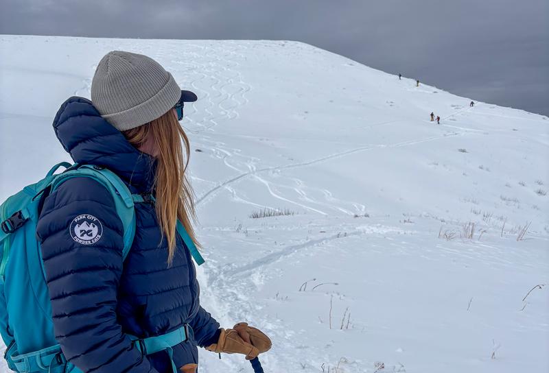
Wolf Creek Pass was buzzing Sunday! Lots of familiar (and some beautiful :) faces out and about enjoying the fresh snow, beautiful day, and even some turns!
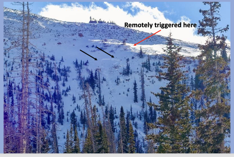
Recent Avalanches

Stubborn, yet reactive... and on Monday, Andy and Trevor remoted this beefy pocket on a steep, rocky, north facing (polar) slope in the wind zone, just under Murdock Peak. This terrain is easily accessed by the still open Mirror Lake Highway. Yup, you can step out of your car at Bald Mountain Pass and immediately walk into avalanche terrain. More on the slide HERE.
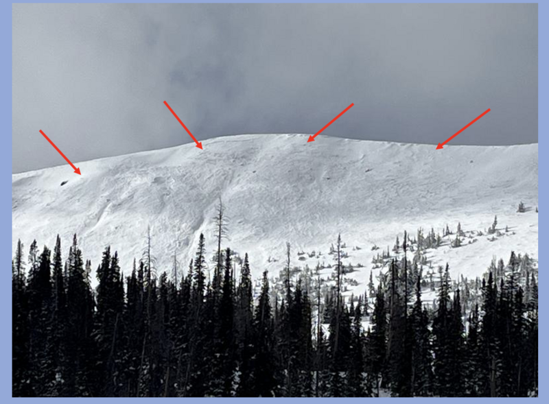
Earlier this week Ted took the sled out for a rip in the Whitney Basin and reported this well-connected yet relatively shallow, natural avalanche on Double Hill.

Lots of additional avalanche activity found HERE.

Avalanche Problem #1
Persistent Weak Layer
Type
Location
Likelihood
Size
Description

Yesterday, ace observer and local snowpro extraordinaire Derek Debruin noted shooting cracks and a talkative snowpack... "circumnavigating Bald Mountain today, and experienced literally dozens of collapses, without regard to aspect, ranging from a few feet to about 100 feet across." More HERE on Derek's most excellent thoughts and insight.

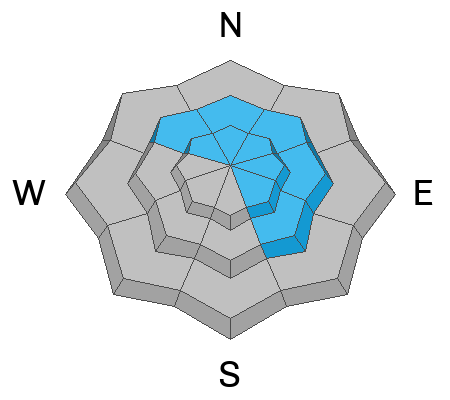
Here's the windup... mid and upper elevation slopes facing the north half of the compass harbor early season snow that grew weak and sugary during the November dryspell. Now that shaky foundation is buried 1-3 feet beneath last weekend's storm. Here's the unsurprising pitch... that's exactly where our problem child, persistent slab avalanches, are found! Bullseye terrain is shady, upper-elevation, rocky slopes where once initiated, today's avalanches can break several feet deep and a couple hundred feet wide. This week, in addition to triggering avalanches remotely, our team of snowpros experienced multiple red flags, like cracking and loud, booming whoomphs. Remember, this is the kind of avalanche dragon we can provoke remotely or from a distance, meaning we don't have to be on a steep slope to trigger the slide.

Look, you don't have to be a snow scientist to take a deeper peak under the snowpack's hood and see what we're talking about. It's not a big dig and a quick shovel excavation reveals a strong, dense slab over weak, sugary snow. That combo creates a trap-door feeling when we're trenching our sled or ski track.

Avalanche Problem #2
Wind Drifted Snow
Type
Location
Likelihood
Size
Description

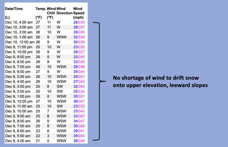
Living up to its namesake, a 24 hour data dump from Windy Peak.

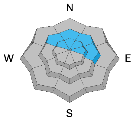
Recent winds have enough loose snow to work with and continue loading our weak snowpack structure. Over the past few days, fresh and sensitive drifts have been pressed into stiff hard slabs on the leeward sides of ridges and upper elevation slopes. Although stubborn, once triggered, today's drifts could break deeper and wider than we might expect, falling on weak snow near the ground. It's a little tricky out there, but remember, we can steer clear of the hazard by looking for and avoiding wind-textured snow and fat, rounded pillows of snow on the leeward side of ridges and around terrain features like chutes and gullies.

General Announcements

We have some upcoming classes and events that we would be stoked to see you at -- Please reach out with any questions and check out below for more details!

We are always looking for snow and avalanche observations or just general riding conditions. Reach out to us with questions, concerns, or if you see anything in your travels! Contact us directly through the info below:

This forecast is from the U.S.D.A. Forest Service, which is solely responsible for its content. This forecast describes general avalanche conditions, and local variations always occur. This forecast was issued on Wednesday, December 10th at 04:00 AM and expires 24 hours after it was issued. We'll update this information by 07:00 AM tomorrow.