Donate to Our Spring Campaign or Bid on our Spring Auction to Support Forecasting

Forecast for the Uintas Area Mountains

Craig Gordon
Issued by Craig Gordon on
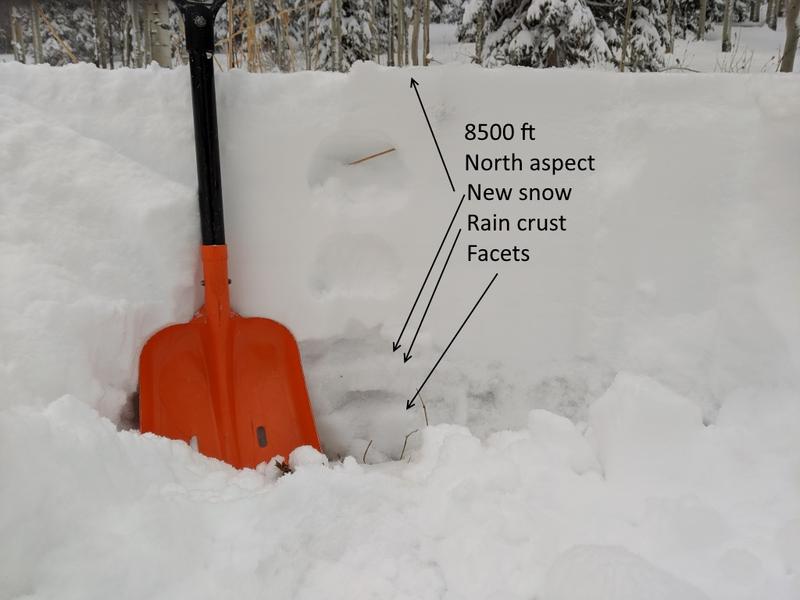
Sunday morning, December 1, 2019
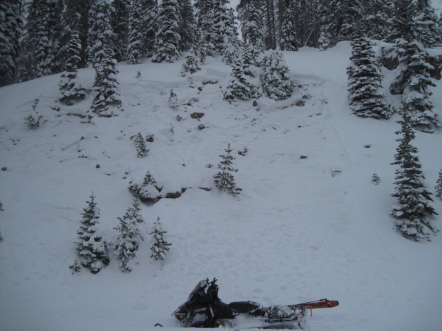
SUNSHINE, FRESH POWDER AND A WEAK SNOWPACK... WE'VE GOT THE PERFECT RECIPE FOR AN AVALANCHE ACCIDENT. TRIGGERING AN AVALANCHE THAT BREAKS ON WEAK SNOW NEAR THE GROUND WILL RESULT IN A DEEP, DANGEROUS SLIDE WHICH WILL INSTANTLY RUIN YOUR DAY.
Avalanche avoidance is key and it's really quite easy.... simply stay off of and out from under steep wind drifted slopes.
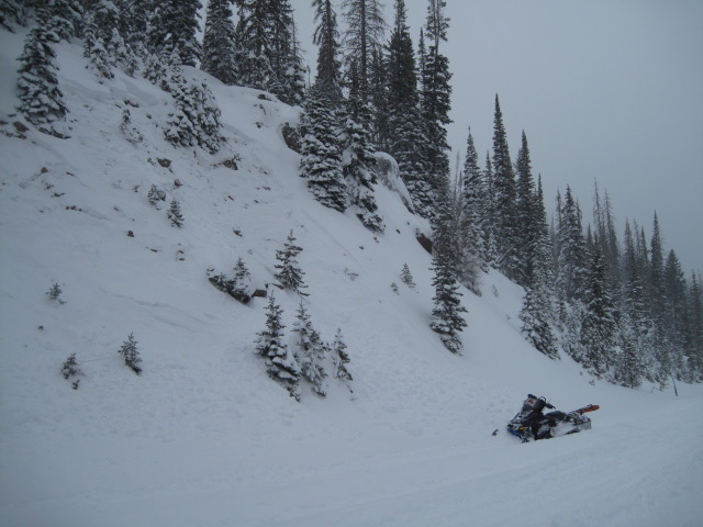
For today, in the wind zone at upper elevations, the avalanche danger is HIGH. Human triggered avalanches are very likely on steep slopes facing the north half of the compass, particularly those that harbor weak, pre-existing snow. Any avalanche that breaks to the ground will instantly ruin your day.
In addition, strong winds whipped up fresh drifts near the ridges at mid and upper elevations, cross-loading terrain and creating dangerous avalanche conditions, especially on slopes facing the north half of the compass. Expect pockets of CONSIDERABLE avalanche danger on steep mid elevation, wind drifted slopes, where human triggered avalanches are likely.
A MODERATE avalanche danger exists on all steep, wind drifted mid or lower elevation slopes and human triggered avalanches are possible.
Here's your exit strategy-
Wind sheltered low elevation terrain that held no old snow prior to the Thanksgiving storm generally offers LOW avalanche danger and human triggered avalanches are unlikely. South facing terrain with no old snow and big open meadows with no steep terrain above or adjacent to where you're riding is the ticket.
Low
Moderate
Considerable
High
Extreme
Learn how to read the forecast here
Avalanche Warning
THE FOREST SERVICE UTAH AVALANCHE CENTER IN SALT LAKE CITY HAS CONTINUED A BACKCOUNTRY AVALANCHE WARNING.
* TIMING...IN EFFECT UNTIL 6AM MST MONDAY MORNING.
* AFFECTED AREA...FOR THE CENTRAL AND SOUTHERN WASATCH RANGE, INCLUDING THE WESTERN UINTAS.
* AVALANCHE DANGER...THE AVALANCHE DANGER TODAY IS HIGH
* REASON/IMPACTS...VERY DANGEROUS AVALANCHE CONDITIONS EXIST. HUMAN TRIGGERED AND NATURAL AVALANCHES ARE LIKELY. STAY OFF OF AND OUT FROM UNDER SLOPES STEEPER THAN 30 DEGREES. AVALANCHES MAY BE TRIGGERED FROM A DISTANCE OR FROM BENEATH STEEP SLOPES.
*ANY AVALANCHE TRIGGERED HAS THE POTENTIAL TO BREAK DEEPER AND WIDER THAN YOU MIGHT EXPECT.... INSTANTLY RUINING YOUR DAY.
And remember-
JUST 'CAUSE YOU CAN SEE YOUR RIG PARKED BY THE SIDE OF THE ROAD NEAR WOLF CREEK PASS DOESN'T NECESSARILY MAKE THE SLOPE YOU CHOOSE TO RIDE MORE SAFE
Weather and Snow
The big Thanksgiving storm was good to the eastern front, delivering an evenly distributed 35" of snow with just over 2" of water. The storm began winding down late yesterday, skies cleared, and temperatures crashed into the single digits. In addition to the storm leaving the stadium, winds finally relaxed, switched to the west, and currently blow 15-25 mph. along the high ridges. We now have a respectable snowpack with total snow depths averaging just over three feet. Travel is a bit more reasonable, but remember.... the Uinta's are made of huge boulders, so rock free roads and meadows are your safest bet.
For today-
It'll be a stunning day in the mountains with a few high clouds drifting through the region. Temperatures warm into the the upper 20's and low 30's with overnight lows in the mid teens. West and southwest winds blow in the 20's along the high peaks. Moisture and winds increase tonight with the approach of several weak disturbances and light snow is possible Monday. A more likely shot of light snow is expected Wednesday night into Thursday, as a weakening storm crosses southern Utah.
Above is 24 hour weather data from Windy Peak (10,662') and Trial Lake (9,945')
Click here for more real time Uinta winds, temperatures, and snow depth.
Recent Avalanches
Friday was a super busy avalanche day on the eastern front. Remember- the biggest clue to avalanches is.... avalanches! And you don't have to go far in order to get a feel for the avy hazard. Ted found these roadbank slides along Highway 150, just below the Ruth Lake Trailhead. More on his travels found here.
And... even if you're just headed out in the high country for a little treejoring to retrieve your family Christmas tree, be aware of your surroundings and avoid being on or under steep, wind drifted slopes. You may be stepping out of your rig and into avalanche terrain.
Ad
Avalanche Problem #1
Persistent Weak Layer
Type
Location
Likelihood
Size
Description
Here's the deal-
Dense, heavy, storm snow coupled with several days of raging winds conspired against the strength of our weak, suspect, and structurally challenged early season snow structure.
Now here's the problem-
The snowpack is settling and gaining strength. As a matter of fact, it'll feel strong underneath our skis, board, or sled. However, we've gotta think not only about the snow we're traveling in, but also the snow we're traveling on and right now, we've got some junk in the trunk. Once triggered, even a small avalanche may break a bit deeper and wider than you might expect, failing on the mid portion of the pack, revealing obstacles hidden under the thin facade of our early season snowpack. Remember- any slide could easily result in a season ending injury if you get raked over stumps, rocks, or deadfall. So the best way to avoid unpredictable avalanche conditions is to avoid where it exists. We can still have a great day by playing in big open meadows and simply staying off of and out from under steep terrain facing the north half fo the compass.
Avalanche Problem #2
Wind Drifted Snow
Type
Location
Likelihood
Size
Description
Wind drifts have relaxed somewhat and probably won't be quite as hair trigger as they've been the past few days. Today, you'll continue finding fat, rounded pillows of snow on the leeward side of upper elevation ridges. But because winds blew from a variety of directions and strength, drifting also occurred lower downslope than we usually expect. In addition, strong winds may cross-loaded terrain features like chutes and gullies. You're best bet for avoidance is to simply steer clear of any fat, rounded piece of snow, especially if it looks chalky or sounds hollow like a drum. In addition, look for and listen to clues like whoomphing sounds or shooting cracks in the snow which are sure signs of unstable conditions.
Prior to the storm I observed weak surface snow last week, but now it's buried and hidden underneath several layers of storm snow. This makes for a tricky setup where we can trigger avalanches from a distance or even an adjacent slope.
On Friday, Micheal J found a suspect snowpack structure at 8,500'. More on his travels here.
Additional Information
The First Annual Avalanche Awareness Week is December 2-7
We have a week full of fun and educational events planned. Check out the schedule here.
As part of your early season tune-up, consider taking an avalanche class. We have lots of avalanche education classes listed already, from Know Before You Go to Companion Rescue to our Backcountry 101. Click on the Education menu on our webpage for a full list of classes from the UAC and other providers. Check out the Know Before You Go eLearning program for free, online, avalanche classes.
Please join me on Friday Dec. 13th at 6:30 for a free avalanche awareness presentation in partnership with Wasatch County SAR. It's guaranteed to be entertaining, informative, and I'll share safety tips that allow you to rip powder safely and come home to your families at the end of the day.... pretty good deal... huh?
General Announcements
The information in this forecast expires in 24 hours, but will be updated by 7:30 AM Monday Dec. 2nd.
Once the snow begins to fly in earnest, this forecast will be updated each day by 7:30 AM.
In the mean-time, if you see or trigger an avalanche or just wanna let me know what you're seeing you can reach me directly at 801-231-2170
It'll be a minute or two before we're riding, but while you're waiting....
This is a great time of year to schedule one of our free avy awareness presentations.
You can email me directly [email protected]
The information in this forecast is from the US Forest Service which is solely responsible for its content.