SAVE THE DATE and TAKE A DATE... SEE YOU NEXT WEDNESDAY NIGHT!
Grab your riding posse and sign up for the 15th Annual
Utah Snow and Avalanche Workshop (USAW). You've got one night left to join us for an evening of solid avy education, delivered by a remarkable group of presenters, all delivered virtually to the comfort of your own home... November 9th. Sign up and get more info
HERE.The
Avalanche Professional and Ski Patrol Snow and Avalanche Workshop (PROSAW) will be during the day of November 7th. Sign up and get more info
HERE.
Get your avy savvy groove goin'-
It's never to early to start thinking about avalanches. A few things to consider doing:
Attend USAW and learn more about avalanches and decision making.
Sign up for an avalanche class.
Take the
online courses listed on the KBYG website (Develop skills -> Online Learning).
Get your avalanche rescue gear ready for winter. Put fresh batteries in your transceiver and update the firmware. Inspect your shovel and probe. Get your airbag backpack ready by possibly doing a test deployment and update the firmware if it is an electric version.
Nowcast- Clear skies and crisp morning temperatures register in the single digits and low teens across the board. Northerly winds blowing 10-15 mph along the high ridges add a bite to the air, as windchill registers to -10 degrees. But, you'll probably forget the cold because the midweek storm lit up the range with a solid foot of snow and meadow skipping on low angle slopes will warm your heart :)
Forecast- A mostly sunny start switches gears later this afternoon with increasing clouds and wind as another storm is slated to slide through the region early Saturday morning. Look for high temperatures climbing into the upper 20's with west-southwest winds bumping into the 30's by days end.
Furturecast- Snow begins falling early Saturday morning and the storm kicks in right around midmorning. The storm should stack up about a foot by late in the day. A break in the action is slated for Sunday with another good looking storm in the queue for Monday.
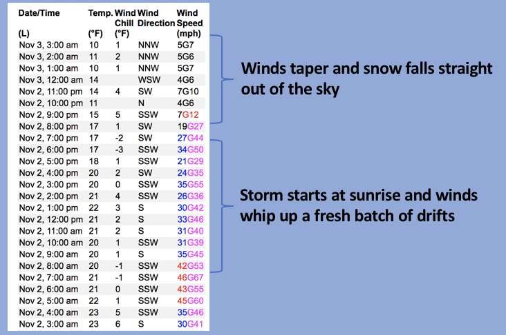
Above is a 24 hour data dump from Lofty Lake Peak (11,186') clearly showing the evolution of the midweek storm.
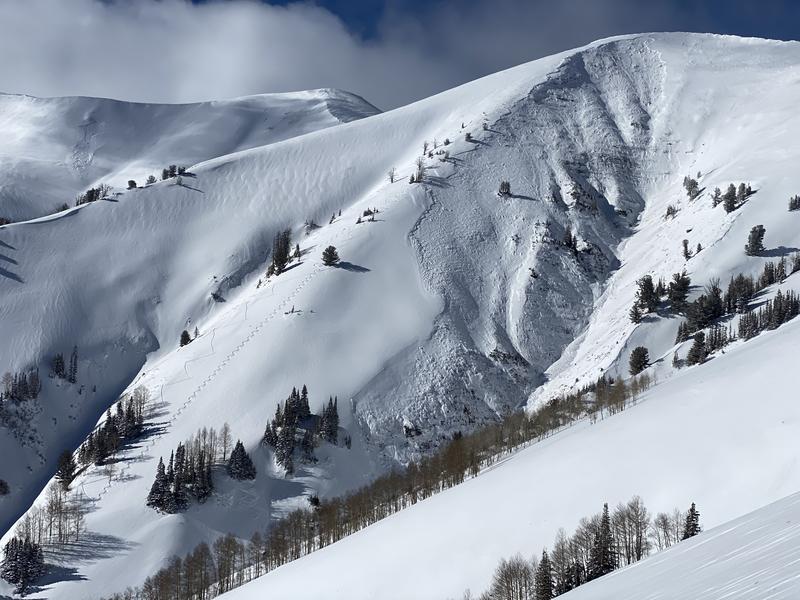
With 12"-16" of midweek storm snow capping off a solid base, there's just enough snow to move around on. Of course, early season roadside attractions like Murdock Bowl off the Mirror Lake Highway or Wolf Creek Bowl along Highway 35 become likely suspects as roadside, park n' ride grabs. Here's the deal... just 'cause you can see it from the road, that doesn't necessarily mean it's safe and good to go. Even though it might not seem like there's enough snow to avalanche, today you'll want to avoid any steep, wind drifted slope. And remember- even a small wind drift packs enough punch to knock you off your feet and may result in a season ending injury if you slam into a stump, rock, or deadfall barely hidden under the shallow snow.
No recent avy activity to report