SAVE THE DATE and TAKE A DATE... SEE YOU NEXT WEDNESDAY NIGHT!
Grab your riding posse and sign up for the 15th Annual
Utah Snow and Avalanche Workshop (USAW). You've got one night left to join us for an evening of solid avy education, delivered by a remarkable group of presenters, all delivered virtually to the comfort of your own home... November 9th. Sign up and get more info
HERE.The
Avalanche Professional and Ski Patrol Snow and Avalanche Workshop (PROSAW) will be during the day of November 7th. Sign up and get more info
HERE.
Get your avy savvy groove goin'-
It's never to early to start thinking about avalanches. A few things to consider doing:
Attend USAW and learn more about avalanches and decision making.
Sign up for an avalanche class.
Take the
online courses listed on the KBYG website (Develop skills -> Online Learning).
Get your avalanche rescue gear ready for winter. Put fresh batteries in your transceiver and update the firmware. Inspect your shovel and probe. Get your airbag backpack ready by possibly doing a test deployment and update the firmware if it is an electric version.
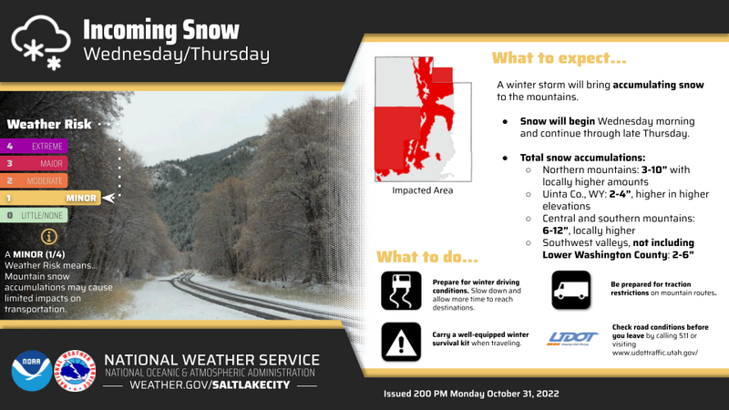
The graphic above lays out the timeline for the continuation of our current storm
Nowcast- Clouds linger over the mountains this morning, squeezing the last bit o' moisture out of yesterday's storm as it exits the state. In its wake, upper elevation terrain, especially surrounding the North Slope, was gifted an evenly distributed 12" of snow and a respectable 1.0" of H2O. The south half of the range was late to the powder party, but offers snow totals in the 8"-10" range. Temperatures register in the low teens whilst northerly winds blowing less than 10 mph hardly spin our automated wind site anemometers, even along the highest peaks. Riding and turning conditions greatly improved in the past 24 hours.
Forecast- The storm winds down, but scattered snow showers linger throughout the morning. Northerly winds remain light and high temperatures only climb into the upper teens and low to mid 20's.
Furturecast- Friday looks like a break in the action, before another round of snow develops for the weekend.
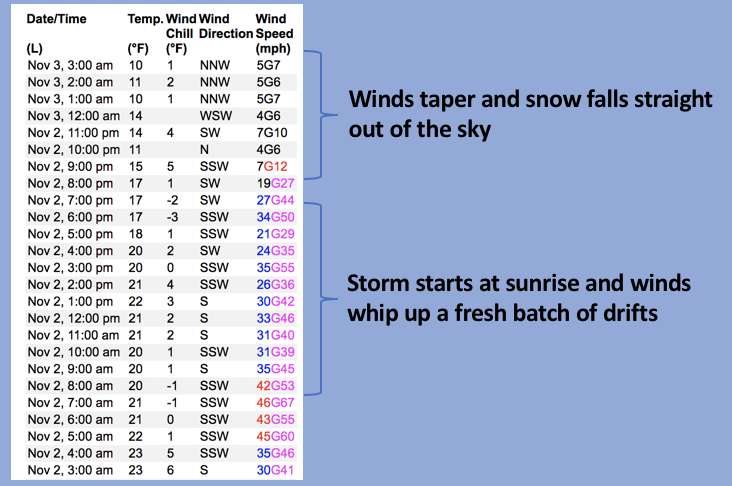
Above is a 24 hour data dump from Lofty Lake Peak (11,186') clearly showing the evolution of yesterday's storm.
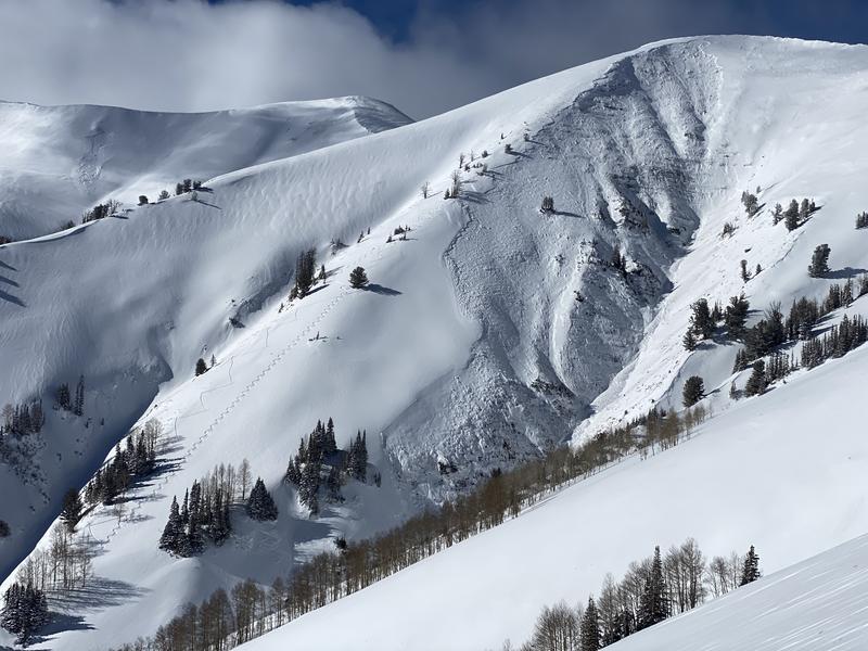
Now there's enough snow to move around on and early season roadside attractions like Murdock Bowl off the Mirror Lake Highway or Wolf Creek Bowl along Highway 35 become likely suspects as roadside, park n' ride grabs. Here's the deal... just 'cause you can see it from the road, that doesn't necessarily mean it's safe and good to go. Even though it might not seem like there's enough snow to avalanche, today you'll want to avoid any steep, wind drifted slope. And remember- even a small wind drift packs enough punch to knock you off your feet and may result in a season ending injury if you slam into a stump, rock, or deadfall barely hidden under the shallow snow.
No recent avy activity to report