Donate to Our Spring Campaign or Bid on our Spring Auction to Support Forecasting

Forecast for the Uintas Area Mountains

Craig Gordon
Issued by Craig Gordon on
Tuesday morning, November 26, 2019
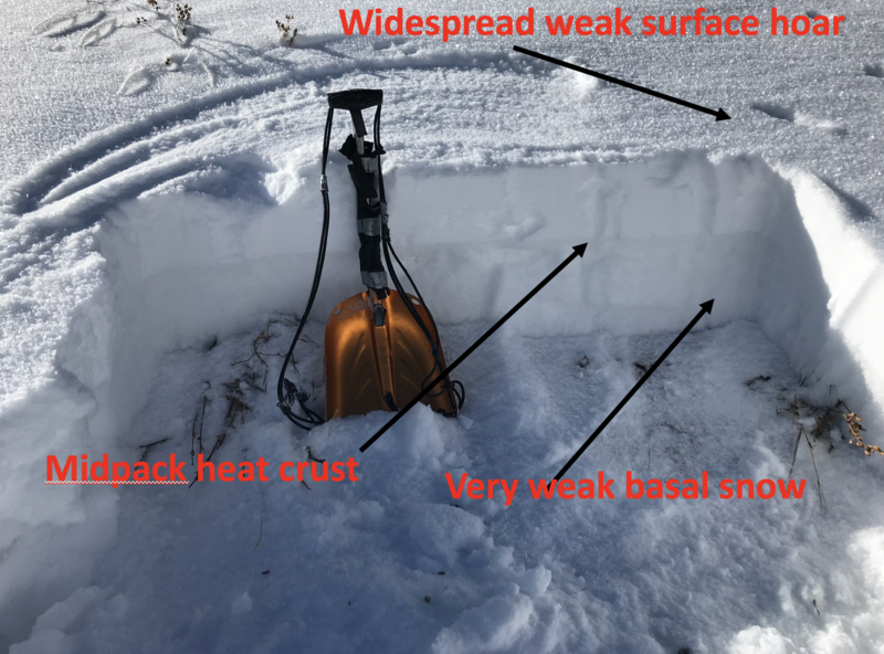
HEADS UP... EXPECT A RAPIDLY RISING AVALANCHE DANGER THE NEXT COUPLE OF DAYS!
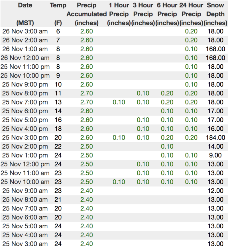
For today, in the wind zone at mid and upper elevations, the avalanche danger is MODERATE. Human triggered avalanches are possible on steep wind drifted slopes, especially those facing the north half of the compass, and particularly those that harbor weak, pre-existing snow. In addition, you may be able to trigger avalanches from a distance or even on a slope adjacent to where you're traveling. Any avalanche triggered has the potential to break deeper and wider than you might expect, revealing a myriad of obstacles that could instantly result in a season ending injury.
Avalanche avoidance is key.... so simply stay off of and out from under steep wind drifted slopes.
And remember-
JUST 'CAUSE YOU CAN SEE YOUR RIG PARKED BY THE SIDE OF THE ROAD NEAR BALD MOUNTAIN OR WOLF CREEK PASS DOESN'T NECESSARILY MAKE THE SLOPE YOU CHOOSE TO RIDE MORE SAFE
Low
Moderate
Considerable
High
Extreme
Learn how to read the forecast here
Avalanche Watch
THE FOREST SERVICE UTAH AVALANCHE CENTER IN SALT LAKE CITY HAS ISSUED A BACKCOUNTRY AVALANCHE WATCH.
* TIMING...IN EFFECT FROM 6AM MST THIS MORNING TO 6AM MST WEDNESDAY MORNING.
* AFFECTED AREA...FOR THE CENTRAL AND SOUTHERN WASATCH RANGE, INCLUDING THE WESTERN UINTAS.
* AVALANCHE DANGER...THE AVALANCHE DANGER IS EXPECTED TO REACH HIGH WITH THE FORECAST SNOW AND WIND.
* REASON/IMPACTS...DANGEROUS AVALANCHE CONDITIONS ARE EXPECTED. HUMAN TRIGGERED AND NATURAL AVALANCHES ARE LIKELY. STAY OFF OF AND OUT FROM UNDER SLOPES STEEPER THAN 30 DEGREES. AVALANCHES MAY BE TRIGGERED FROM A DISTANCE OR FROM BENEATH STEEP SLOPES.
Special Announcements
The First Annual Avalanche Awareness Week is December 2-7
We have a week full of fun and educational events planned. Check out the schedule here.
As part of your early season tune-up, consider taking an avalanche class. We have lots of avalanche education classes listed already, from Know Before You Go to Companion Rescue to our Backcountry 101. Click on the Education menu on our webpage for a full list of classes from the UAC and other providers. Check out the Know Before You Go eLearning program for free, online, avalanche classes.
Please join me on Friday Dec. 13th at 6:30 for a free avalanche awareness presentation in partnership with Wasatch County SAR. It's guaranteed to be entertaining, informative, and I'll share safety tips that allow you to rip powder safely and come home to your families at the end of the day.... pretty good deal... huh?
Weather and Snow
Yesterday's storm materialized nicely for the eastern front with 6"-10" of light density snow stacking up in short order. Favored areas on the North Slope were able to squeeze out close to a foot of light fluff. Overnight, skies cleared and temperatures crashed into the teens and single digits. It's a bit rugged along the ridges where northwest winds blow in the 20's and 30's, creating windchill factors deep into negative territory. Total snow depths now average just under two feet making travel a bit more reasonable, but remember.... the Uinta's are made of huge boulders, so rock free roads and meadows are your safest bet.
Brian McInerney, our good friend and ace forecaster at the National Weather Service, brilliantly delivers the evolution of the upcoming storm in the video above.
Above is 24 hour weather data from Windy Peak (10,662') and Trial Lake (9,945')
Click here for more real time Uinta winds, temperatures, and snow depth.
I stomped around Wolf Creek Pass on Sunday and found there's hardly enough snow to recreate on just yet, but you can gently move around on rock free meadows and roads.
Meanwhile, Derek send it a great observation from the Bald Mountain zone and found more rock than snow. Click here for a trip report from that area.
Recent Avalanches
No new avalanche activity to report
Ad
Avalanche Problem #1
Persistent Weak Layer
Type
Location
Likelihood
Size
Description
There's two main avalanche issues today... a persistent weak layer of snow buried in our snowpack and fresh pockets of wind drifted snow. I'll start off with the avalanche dragon that's most unpredictable and could instantly ruin my day... which is, the persistent weak layer now buried under yesterday's storm. Here's the setup-
Upper elevation slopes facing the north half of the compass are really the only game in town, but they're also the most dangerous because they harbor weak, shallow, old snow left over from early season storms. Life was good with our fragile snowpack until yesterday's storm rolled into town, delivering a one-two combo of snow and wind, which created a layer of strong snow on top of our weak snowpack. The problem with this structure is, it's gonna feel strong underneath us. However, we've gotta think not only about the snow we're traveling in, but also the snow we're traveling on and right now, we've got some junk in the trunk. Once triggered, even a small avalanche may break a bit deeper and wider than you might expect, failing on the mid portion of the pack, revealing obstacles hidden under the thin facade of our early season snowpack. Remember- any slide could easily result in a season ending injury if you get raked over stumps, rocks, or deadfall. So the best way to avoid unpredictable avalanche conditions is to avoid where it exists. We can still have a great day by playing in big open meadows and simply staying off of and out from under steep terrain facing the north half fo the compass.... easy :)
Avalanche Problem #2
Wind Drifted Snow
Type
Location
Likelihood
Size
Description
Winds were all over the map prior to, during, and after yesterday's quick hitting system, whipping the light density snow into wind drifts that'll be sensitive to our additional weight. Today's drifts are found on the leeward side of upper elevation ridges and because of variable wind directions, they've formed on nearly every quadrant of the compass and may have cross-loaded into chutes and gullies. You're best bet for avoidance is to simply steer clear of any fat, rounded piece of snow, especially if it looks chalky or sounds hollow like a drum. In addition, look for and listen to clues like whoomphing sounds or shooting cracks in the snow which are sure signs of unstable conditions.
I observed weak surface snow over the weekend, but now it's buried and hidden underneath yesterday's storm snow. This makes for a tricky setup where we can trigger avalanches from a distance or even an adjacent slope.
General Announcements
The information in this forecast expires in 24 hours, but will be updated by 7:30 AM Wednesday Nov. 27th. Once the snow begins to fly in earnest, this forecast will be updated each day by 7:30 AM.
In the mean-time, if you see or trigger an avalanche or just wanna let me know what you're seeing you can reach me directly at 801-231-2170
It'll be a minute or two before we're riding, but while you're waiting....
This is a great time of year to schedule one of our free avy awareness presentations.
You can email me directly [email protected]
The information in this forecast is from the US Forest Service which is solely responsible for its content.