Donate to Our Spring Campaign or Bid on our Spring Auction to Support Forecasting

Forecast for the Uintas Area Mountains

Craig Gordon
Issued by Craig Gordon on
Monday morning, November 25, 2019
Making up a very small portion of a very large range, in the wind zone, at and above treeline the avalanche danger will rise to MODERATE as todays storm materializes. As new snow stacks up, human triggered avalanches will be possible on steep wind drifted slopes, especially those facing the north half of the compass, and particularly those that harbor weak, pre-existing snow. Any avalanche triggered will reveal a myriad of obstacles and could instantly result in a season ending injury.
And....
JUST 'CAUSE YOU CAN SEE YOUR RIG PARKED BY THE SIDE OF THE ROAD NEAR BALD MOUNTAIN OR WOLF CREEK PASS DOESN'T NECESSARILY MAKE THE SLOPE YOU CHOOSE TO RIDE MORE SAFE
Low
Moderate
Considerable
High
Extreme
Learn how to read the forecast here
Special Announcements
The First Annual Avalanche Awareness Week is December 2-7
We have a week full of fun and educational events planned. Check out the schedule here.
As part of your early season tune-up, consider taking an avalanche class. We have lots of avalanche education classes listed already, from Know Before You Go to Companion Rescue to our Backcountry 101. Click on the Education menu on our webpage for a full list of classes from the UAC and other providers. Check out the Know Before You Go eLearning program for free, online, avalanche classes.
Please join me on Friday Dec. 13th at 6:30 for a free avalanche awareness presentation in partnership with Wasatch County SAR. It's guaranteed to be entertaining, informative, and I'll share safety tips that allow you to rip powder safely and come home to your families at the end of the day.... pretty good deal... huh?
Weather and Snow
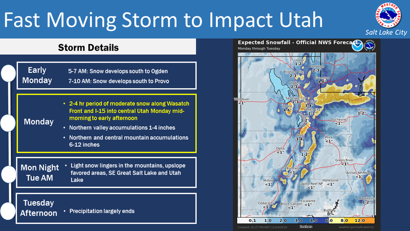
Clouds stream into the area this morning ahead of a quick moving storm slated to impact northern Utah just after sunrise. Overnight, west and southwest winds ramped into the mid and upper 30's and temperatures dipped into the teens and low 20's, where they sit early this morning. No new snow has fallen in the past 24 hours and total snow depths average just about a foot.
Looks like a pattern change is on tap and a fast moving cold front brings a quick shot of snow to the area in the next couple of hours. West and northwest winds bump into the 30's and snow develops later this morning. High temperatures don't vary much from where we're at now and overnight lows dip into the single digits. While mostly a Cottonwood Canyons oriented storm, the eastern front should squeeze out 6"-8" of snow by early Tuesday. A break in the action is slated for late Tuesday and early Wednesday with a cool and unsettled pattern continuing for much of the remainder of the upcoming week.
Above is 24 hour weather data from Windy Peak (10,662') and Chalk Creek (9,169')
Click here for more real time Uinta winds, temperatures, and snow depth.
I stomped around Wolf Creek Pass yesterday and found there's hardly enough snow to recreate on just yet, but you can gently move around on rock free meadows and roads.
Meanwhile, Derek send it a great observation from the Bald Mountain zone and found more rock than snow. Click here for a trip report from that area.
Recent Avalanches
No new avalanche activity to report
Ad
Avalanche Problem #1
Persistent Weak Layer
Type
Location
Likelihood
Size
Description
Upper elevation slopes facing the north half of the compass have a couple of structural issues, generally harboring weak, shallow, old snow left over from early season storms. This makes for a potentially dangerous setup now that winter is kicking in.
Here's the problem... this terrain is the only game in town and this is exactly the type of terrain that'll become a problem, especially as a series of storms is slated to slide through the region this week. As today's snow stacks up the avalanche danger will rise, and once triggered, even a small avalanche may break a bit deeper and wider than you might expect, revealing obstacles hidden under the thin facade of our early season snowpack. Remember- any slide could easily result in a season ending injury if you get raked over stumps, rocks, or deadfall.
General Announcements
The information in this forecast expires in 24 hours, but will be updated by 7:30 AM Tuesday Nov. 26th. Once the snow begins to fly in earnest, this forecast will be updated each day by 7:30 AM.
In the mean-time, if you see or trigger an avalanche or just wanna let me know what you're seeing you can reach me directly at 801-231-2170
It'll be a minute or two before we're riding, but while you're waiting....
This is a great time of year to schedule one of our free avy awareness presentations.
You can email me directly [email protected]
The information in this forecast is from the US Forest Service which is solely responsible for its content.