Forecast for the Uintas Area Mountains

Craig Gordon
Issued by Craig Gordon for
Friday, January 20, 2023
About as straight-forward as it gets-
MODERATE avalanche danger is found on upper elevation leeward slopes, especially in the wind zone at and above treeline. Fresh wind drifts reactive to our additional weight are POSSIBLE.
Generally LOW avalanche danger is found on all mid and lower elevation slopes.

Low
Moderate
Considerable
High
Extreme
Learn how to read the forecast here
Special Announcements
Are you snowpack curious... wondering how it went from Zero to Hero? Well then, you came to the right place! Please join me 6:00 next Monday, January 23rd at the Kimball Junction Library for a State of the Snowpack prezo. It's gonna be informative, educational, and quite possibly entertaining :)
Weather and Snow
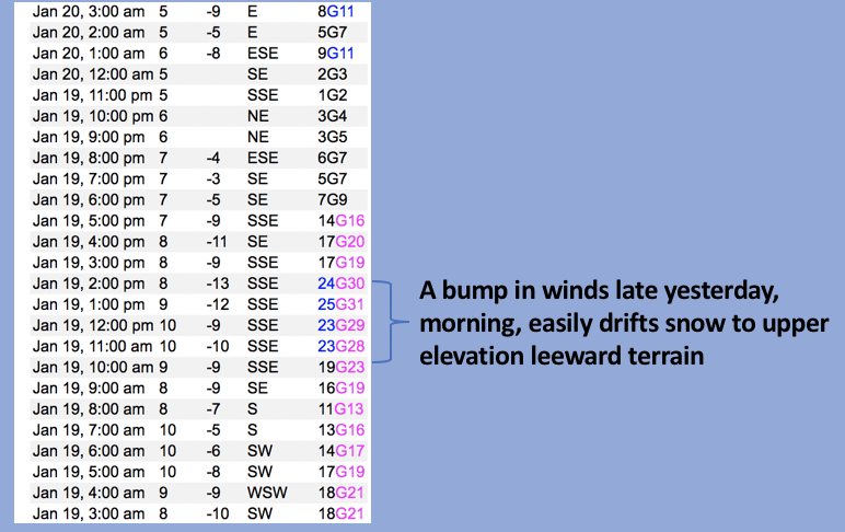
Nowcast- A rather robust storm chugs along to the south of us, but we're not left totally high and dry as a trace, or perhaps even a couple traces of snow stacked up overnight. Under mostly cloudy skies, scattered snow showers linger over the eastern front and temperatures register in the single digits. Along the high ridges, east and northeast winds remain rather well-behaved, blowing just 5-10 mph. Mid week winds damaged our big, open alpine terrain, but sheltered slopes harbor excellent riding conditions.
Forecast- High pressure briefly visits northern Utah, delivering partly cloudy skies, as northeast winds blow 5-15 mph along the high peaks. Temperatures are gonna be cold with highs barely clawing their way into the low 20's while overnight lows crater into negative territory.
Futurecast- Another weak storm clips the northern half of the state for late Saturday into Sunday. Clear, dry, and cold for the upcoming week with little brush-bys slated every other day.

Mark describes how current snowpack depths are helping the pack turn the corner in the viddy above. This strongly aligns with reasoning to pull the plug on our problem child, the Persistent Weak Layer, which has plaguied us since late November... whew!
In addition, our main man Ted Scroggin, has an excellent observation and offers his usual keen insight from a recent Gold Hill stomp around.
Huge thanks for all the great obs streaming in from the eastern front. Detailed trip reports and recent obs are found HERE.
Recent Avalanches
Other than a shallow wind drift or two, no significant avy activity to report. But a slew of Uinta avy obs are found HERE.
Ad
Avalanche Problem #1
Wind Drifted Snow
Type
Location
Likelihood
Size
Description
Data dump from Windy Peak (10,662') shows a slight bump in Thursday morning winds.
There's no shortage of snow available to blow around and yesterdays early afternoon wind had no problem whipping up a fresh round of shallow drifts sensitive to our additional weight. Found on upper elevation leeward slopes and manageable in size, this is an easy avalanche dragon to avoid... lose a little elevation, you lose the wind and you lose the problem.

Additional Information
Come as you are or grab your black tie... in either case I'd like to visit with you Monday night :)
Weather stations-
And... rime events have severely crippled the Uinta weather station network. I'm working to get it back up and running, but a few stations are found HERE (click weather stations, and then on the Western Uinta tab)
Observations-
Your observations are important, so please let me know what you're seeing... click HERE and contribute to this amazing community-based program
General Announcements
Issued at 03:43 on Friday January 20th, this forecast expires 24 hours after the date and time posted, but will be updated by 07:00 Saturday January 21st, 2023.
Before it gets too crazy, now is the time to book an avalanche awareness presentation for your group, club, or posse. You can reach Craig directly at 801-231-2170 or [email protected].

This forecast is from the U.S.D.A. Forest Service, which is solely responsible for its content. This forecast describes general avalanche conditions and local variations always occur.