Forecast for the Skyline Area Mountains

Brett Kobernik
Issued by Brett Kobernik for
Friday, April 8, 2022
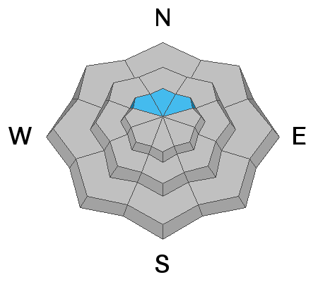
The majority of the terrain on the Skyline has a LOW avalanche danger.
You can pretty much travel around most anywhere and be at ease that you won't trigger an avalanche.
However, there is still a chance that a person could trigger a large and deadly avalanche on northerly facing slopes steeper than 30˚ above about 10,000'.
One other thing to consider is that if for some reason you are in the mid or lower elevations and you find yourself in knee or waist deep slushy wet snow, avoid being on steep slopes and in gullies and ravines with steep walls.
Low
Moderate
Considerable
High
Extreme
Learn how to read the forecast here
Weather and Snow
Current Conditions
Overnight temperatures were fairly mild with most weather stations hovering around freezing or a bit warmer. With clear skies, the snow surface should've frozen up a bit anyway despite the above freezing temperatures. This doesn't really make sense but it happens because the snow cools due to temperature loss through outgoing radiation. It's kind of like voodoo. You can't see it but it does happen. The wind has really dropped off and is almost calm.
Mountain Weather
Today is going to be the warmest day of the week with sun, high temperatures into the low 50s and calm to light west northwest wind. Saturday is similar with a few scattered clouds and slightly cooler temperatures. Sunday looks nice also but colder air moves in with highs only around freezing. It appears that we'll have some snow next week as weather models continue to hint at a fairly active pattern. It actually looks fairly active through the end of the month with a number of potential storm.
Ad
Avalanche Problem #1
Persistent Weak Layer
Type
Location
Likelihood
Size
Description
The Persistent Weak Layer that formed mid winter is really your only serious threat out there today. In theory, as time goes on, it should continue to stabilize and stop producing avalanches. I cannot say whether it has reached this point yet. What I do know is that it is a very unusual layer of weak snow that has produced an unprecedented string of avalanches here on the Skyline. It's tricked me once into thinking it was stable.
The places you could still find trouble are on VERY steep northerly facing slopes above about 10,000'. We want to recreate in that north facing terrain right now because that's where the good quality snow is. The easiest thing to do is to keep your slope angles to 30˚ or below. Be sure there's nothing steeper than 30˚ above you also as you could still trigger one of these beasts from below.
General Announcements
This forecast is from the U.S.D.A. Forest Service, which is solely responsible for its content. This forecast describes general avalanche conditions and local variations always occur.