UDOT PLANNED AVALANCHE CLOSURES!!

Forecast for the Skyline Area Mountains

Brett Kobernik
Issued by Brett Kobernik for
Thursday, April 7, 2022
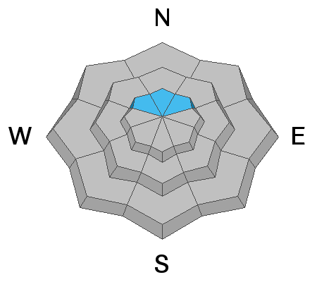
The majority of the terrain on the Skyline has a LOW avalanche danger.
You can pretty much travel around most anywhere and be at ease that you won't trigger an avalanche.
However, there is still a chance that a person could trigger a large and deadly avalanche on northerly facing slopes steeper than 30˚ above about 10,000'.
Avoid those slopes and you will stay safe.
Low
Moderate
Considerable
High
Extreme
Learn how to read the forecast here
Weather and Snow
Current Conditions
Temperatures stayed cold on Wednesday with only the more direct sunny slopes becoming slightly damp late afternoon. Temperatures dropped back to around 20˚F overnight and the strong northwest wind is now pretty light.
Mountain Weather
We'll have sun today with temperatures into the mid 40s and light to moderate speed northwest wind. The rest of the week looks similar. Temperatures are warmer on Friday and we'll see some scattered clouds through the weekend. The next chance for snow is around Tuesday of next week. As of now it looks like a decent storm.
Ad
Avalanche Problem #1
Persistent Weak Layer
Type
Location
Likelihood
Size
Description
This winter's Persistent Weak Layer that formed in Jan/Feb is a very unique and unusual problem. We have very few avalanches in our database that break into sugary facets at this time of the season. Under normal situations, the big warm up a couple of week's ago should've ended this problem. But, the layer of facets has produced large avalanches since then. I continue to avoid the steepest northerly facing slopes. I'm not sure when we will be able to call those slopes 100% stable.
General Announcements
This forecast is from the U.S.D.A. Forest Service, which is solely responsible for its content. This forecast describes general avalanche conditions and local variations always occur.