Forecast for the Skyline Area Mountains

Brett Kobernik
Issued by Brett Kobernik for
Thursday, March 9, 2023
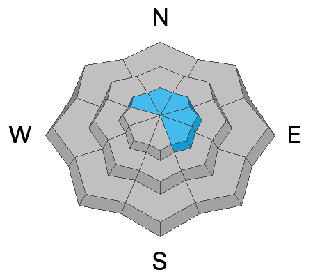
A MODERATE avalanche danger rating exists in the upper elevation steep slopes that face northwest through southeast.
Gusty wind and a little new snow overnight have created some fresh drifts that could be sensitive today.
The most likely places to trigger an avalanche will be on very steep slopes that face northwest through southeast in the upper elevations.
If you avoid areas with recent deposits of wind drifted snow the avalanche danger is LOW.
Low
Moderate
Considerable
High
Extreme
Learn how to read the forecast here
Special Announcements
To help you safely enjoy the backcountry, the UAC team is constantly evaluating and implementing new programs and technologies. Donate to the Spring Campaign to help our team implement innovative tools and better provide you with the information you rely on.
Weather and Snow
Current Conditions: A quick hitting blustery storm moved through last night bringing a trace to a couple of inches of snow. The wind was pretty stiff for a while and is now showing signs of slowing. Temperatures on Wednesday were around 30˚F and cooled into the low teens overnight. Riding conditions will be hit or miss today with a mix of recent melt freeze crusts, wind crusts, but also lots of areas of soft settled snow.

Mountain Weather: The wind should continue to slow today and temperatures will get into the upper 20s or low 30s. We should have clear skies most of the day. An interesting looking storm moves in on Friday bringing warm and wet conditions. The rain/snow level will probably start out up around 8000 feet or possibly higher. Rain on snow could produce natural avalanches in the lower elevations. The new snow is going to be dense. It looks like a pretty windy storm also. There will be a little break Saturday then another impulse on Sunday. Weather models advertise up to 2" of water with this storm which could give us 2 feet of snow. Although, with anticipated high density snow, it may not measure that much.
Ad
Avalanche Problem #1
Wind Drifted Snow
Type
Location
Likelihood
Size
Description
Our pattern of small wind drifted snow avalanches continues today. The threat is not huge but if you're looking for trouble, you can probably find it. A little snow and some wind overnight drifted snow around and you'll find some fresh drifts today. The most likely spots to trigger something are going to be on very steep more easterly facing slopes. Avoid cornices and steep slopes below them.
General Announcements
This forecast is from the U.S.D.A. Forest Service, which is solely responsible for its content. This forecast describes general avalanche conditions and local variations always occur.