Forecast for the Skyline Area Mountains

Brett Kobernik
Issued by Brett Kobernik for
Monday, March 7, 2022
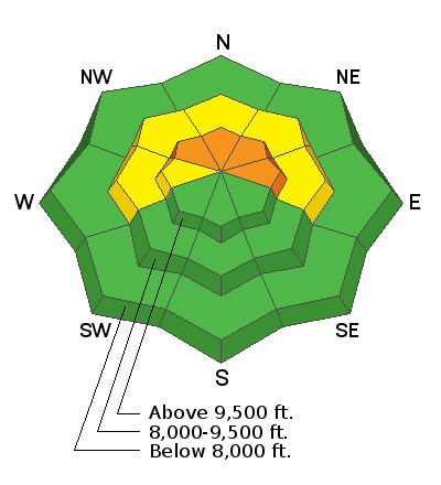
The avalanche danger remains CONSIDERABLE on the Manti Skyline.
New snow and wind has increased the danger. Human triggered slab avalanches are likely.
If you avoid steep upper elevation northerly facing terrain, the avalanche danger is dramatically lower.
Low
Moderate
Considerable
High
Extreme
Learn how to read the forecast here
Weather and Snow
Current Conditions
A cold unstable northwest flow produced 5 to 7 inches of snow on Sunday during the last wave of the storm. This was better than I anticipated. I find that the pattern with cold unstable northwest flow can really favor the central Skyline from around Pleasant Creek through Manti Canyon or even a bit more south. Fairview Canyon does not do as well with this flow and additional accumulations there were less. Storm totals since Friday are 10 to 16". The wind is notable. It was stronger during the last wave than I was expecting and this caused quite a bit of drifting. This will be a significant contributor to avalanche danger. High temperatures on Sunday were around 20˚F and dropped into the single digits overnight. Northwest wind has slowed dramatically.
Mountain Weather
Low level clouds may linger today. We may see them break a bit but the mountains could stay socked in also. Highs will be in the mid to upper teens and northwest wind should remain fairly light. Tuesday starts out clear then clouds move in ahead of the next storm Tuesday night through Wednesday. This storm looks like a decent little event with around 8 inches of new snow possible.
Ad
Avalanche Problem #1
Persistent Weak Layer
Type
Location
Likelihood
Size
Description
By far, the buried Persistent Weak Layer of sugary facets is your biggest concern today. We've picked up 10 to 16 inches of snow since Friday with significant wind. This will increase the chance of human triggered avalanches today. The most likely places to trigger something are on steep slopes above about 9500' that face northwest, north, northeast and east. The buried layer is still very loose. Snowpit stability test results are still poor in these locations. All you can do is avoid this terrain until we see improved stability.
General Announcements
This forecast is from the U.S.D.A. Forest Service, which is solely responsible for its content. This forecast describes general avalanche conditions and local variations always occur.