UDOT PLANNED AVALANCHE CLOSURES!!

Forecast for the Skyline Area Mountains

Brett Kobernik
Issued by Brett Kobernik for
Saturday, March 5, 2022
The avalanche danger is increasing as we add more snow.
There is a CONSIDERABLE avalanche danger in the upper elevation more northerly facing terrain.
Human triggered slab avalanches are likely.
Avalanches can be triggered from a distance right now so stay out from underneath steep slopes as you could trigger one that comes down on you.
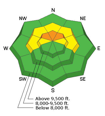
Low
Moderate
Considerable
High
Extreme
Learn how to read the forecast here
Weather and Snow
Current Conditions
The Skyline picked up 4 to 5 inches of snow in the last 24 hours. Temperatures cooled into the low to mid 20s. Southerly wind has increased into the moderate speed category along the higher terrain. Wind looks pretty light down in the canyons.
Mountain Weather
Here's how the rest of the storm looks like it'll play out. Our best chance for snow will be later this afternoon and into tonight with a southerly flow. 5 to 8 inches is what I'm expecting. As the system continues to move through, the flow will shift northwest and we'll see one more period of light snow on Sunday. At this point it doesn't look like it'll add much more than a trace to a few inches. The next chance of snow is a storm shaping up for Wednesday.
Recent Avalanches
There was no avalanche activity reported from Friday. Here are some interesting statistics from recently.
  • I've recorded 26 significant avalanches since Feb 17. I have two more to add this morning. This does not include a slew of smaller slab avalanches scattered around the range.
  • 12 of these have been human triggered avalanches. One more that I'm adding this morning was also human triggered. There were a number more that I heard of but details are vague.
  • All of the avalanches I've recorded were higher than 9700'.
  • The slope aspects of these avalanches ranged from northwest, north, northeast and east. The majority were recorded as northeast.
Here is the complete list: SKYLINE AVALANCHE LIST
Ad
Avalanche Problem #1
Persistent Weak Layer
Type
Location
Likelihood
Size
Description
By far the biggest concern is triggering an avalanche that breaks into weak sugary snow that formed in January and early February. This buried Persistent Weak Layer is down about 12 to 18" plus the 4 inches of new snow we just received. This layer is still quite unstable with the most recent snowmobile remotely triggered slide occurring on Thursday. The most likely places to trigger a slide are slopes steeper than 30˚ on northwest, north, northeast and east facing slopes above 9500'. Buried sugary faceted snow is notorious for being unpredictable. This type of situation is what kills most people in avalanche accidents. You can't outthink it. All you can do is wait to get onto steep slopes until the weak layer has stabilized. This sugary faceted snow is also notorious for taking a long time to stabilize, hence the reason we call it a Persistent Weak Layer.
General Announcements
This forecast is from the U.S.D.A. Forest Service, which is solely responsible for its content. This forecast describes general avalanche conditions and local variations always occur.