UDOT PLANNED AVALANCHE CLOSURES!!

Forecast for the Skyline Area Mountains

Brett Kobernik
Issued by Brett Kobernik for
Monday, March 4, 2019
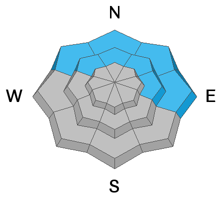
The avalanche danger is MODERATE today. Lingering slabs of wind drifted snow might still be triggered by a person. These will be most pronounced along the ridges. The snow may become wet to the point that wet snow avalanches could release later today as well. Sunny slopes and all lower elevation terrain is the most likely place for this issue.
If you continue to pay attention to your surroundings, you will be able to travel around quite safely today.
Low
Moderate
Considerable
High
Extreme
Learn how to read the forecast here
Weather and Snow
Another 6 to 8 inches of snow fell in the last 24 hours. This pushes snow totals since Thursday night to almost 20 inches. It was again fairly dense snow containing rimed crystals or "graupel". It was perhaps not quite as dense as it was earlier in the storm. Riding conditions are excellent although it's not quite the deep powder we've been accustomed to.
Ad
Avalanche Problem #1
Wind Drifted Snow
Type
Location
Likelihood
Size
Description
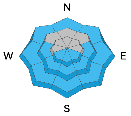
The wind hasn't been outrageous but it did drift enough snow to form some sensitive wind slabs. My partner was able to intentionally get one to release on a test slope that we found on Sunday. It clearly demonstrates that things were somewhat sensitive. As we approach Spring, conditions change more rapidly. These fresh drifts may have stabilized and might not budge today. However, it's your job to do your homework to see how sensitive things are before just jumping into steep slopes. Look for test slopes like the one in the video below as you travel to try and figure out if the fresh drifts are still sensitive.
Avalanche Problem #2
Wet Snow
Type
Location
Likelihood
Size
Description
Another Springtime concern is wet avalanche activity. This especially a concern directly following a storm when the cold new snow gets heated up for the first time. This could be an issue later today depending on how much clearing we see and how warm it gets. Watch for "rollerballs" or "pinwheels" on the surface of the snow which indicates things are getting wet and it's time to move off those steep slopes.
Avalanche Problem #3
Persistent Weak Layer
Type
Location
Likelihood
Size
Description
Shallow areas are still holding very weak sugar snow near the ground that could fail under the new snow load. This is more of an issue in the mid and lower elevation terrain. What's a little tricky is that since we have enough snow to travel into lower elevation terrain, we don't usually think so much about avalanches in these areas. Avoid steep slopes anywhere you find unsupportable snow like in the video below.
Additional Information
This forecast is from the U.S. Forest Service, which is solely responsible for its content. This forecast describes general avalanche conditions and local variations always occur.