UDOT PLANNED AVALANCHE CLOSURES!!

Forecast for the Skyline Area Mountains

Brett Kobernik
Issued by Brett Kobernik for
Monday, March 21, 2022
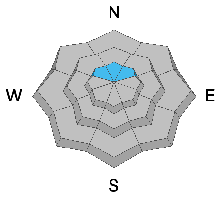
A CONSIDERABLE avalanche danger exists on steep slopes above 9500' that face northwest, north and northeast.
Human triggered avalanches breaking 3 feet deep in these locations are likely.
Fresh deposits of wind drifted snow in these areas have increased the chances for triggering a dangerous avalanche.
Low
Moderate
Considerable
High
Extreme
Learn how to read the forecast here
Special Announcements
Please help support avalanche forecasting throughout Utah. DONATE TO THE SPRING CAMPAIGN to help raise the funds to support the forecasting you rely on.
Weather and Snow
Current Conditions
Sunday's storm panned out about as expected with a trace to about 4 inches of new snow depending on location. The Fairview Canyon area received 3 to 4 inches. The Central Skyline around the Horseshoes did better than expected with up to 9 inches. Ephraim Canyon came in at about 5 inches. The southern end only picked up a trace to a couple of inches. Northwest wind has been moderate in speed. Strong enough to drift the new snow. Temperatures started dropping around noon Sunday as the storm moved in and have bottomed out in the low to mid teens.
Mountain Weather
Today will bring some scattered clouds, high temperatures in the low 20s and moderate speed northerly wind. It will probably feel a little breezy along the higher ridges. We start a gradual warming trend on Tuesday with warmer temperatures each day through the weekend. We could see daytime highs into the 50s by the weekend.
Ad
Avalanche Problem #1
Persistent Weak Layer
Type
Location
Likelihood
Size
Description
The new snow itself should not pose much of a threat where the buried Persistent Weak Layer of snow does not exist. Where it does exist (upper elevation more northerly facing slopes) even the small amount of new snow combined with a little wind has increased the possibility of triggering a deep avalanche. The only safe bet is to avoid those steep upper elevation northerly facing slopes until we are sure the snowpack is stable. Here are a few thoughts on how things might play out this week:
  • I am hopeful that the string of warm days this week is enough to settle and strengthen the snowpack to the point that it is stable. Warm temperatures help stabilize the snowpack more so than mid winter cold temperatures.
  • The flip side is that when temperatures get too warm, they can actually decrease the strength of the snowpack. It is very possible that later in the week temperatures may get warm enough to weaken the snowpack and we could see a round of natural avalanches breaking into the Persistent Weak Layer from Jan/Feb. The one thing we have on our side is that this is a gradual warming trend which allows the snowpack to slowly adjust. However, it looks awefully warm by next weekend so we'll want to pay close attention to the state of the pack by then.
General Announcements
This forecast is from the U.S.D.A. Forest Service, which is solely responsible for its content. This forecast describes general avalanche conditions and local variations always occur.