Forecast for the Skyline Area Mountains

Brett Kobernik
Issued by Brett Kobernik for
Sunday, March 20, 2022
The majority of the terrain on the Skyline has a LOW to MODERATE avalanche danger.
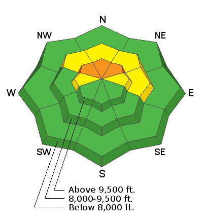
A CONSIDERABLE danger remains on upper elevation northwest, north, and northeast facing slopes steeper than 35˚.
Human triggered avalanches are still a distinct possibility.
Conditions remain dangerous in the upper elevation northerly facing terrain because we cannot determine which slopes will stay in place and which ones will avalanche.
Low
Moderate
Considerable
High
Extreme
Learn how to read the forecast here
Special Announcements
Please help support avalanche forecasting throughout Utah. DONATE TO THE SPRING CAMPAIGN to help raise the funds to support the forecasting you rely on.
Weather and Snow
Current Conditions
Snow conditions on Saturday stayed fairly decent despite temperatures getting up to around 40. It felt a little breezy along the higher ridges although anemometers weren't picking up anything significant. The wind did pick up overnight from the southwest and was strong along the highest peaks. Overnight temperatures hovered around freezing.
Mountain Weather
A splitting storm system dives to our south resulting in a minor storm event in our area today. A trace to a couple of inches of snow is possible by Monday. Temperatures will remain around 30˚F and then fall with colder air moving in tonight. Southwest wind will be in the moderate speed category and increase tonight as it switches northwest. Temperatures on Monday will be in the mid 20s and then we'll have a gradual warming trend through the rest of the week.
Ad
Avalanche Problem #1
Persistent Weak Layer
Type
Location
Likelihood
Size
Description
The buried Persistent Weak Layer that formed in Jan/Feb still concerns me. While riding snowbikes on Saturday, my partners and I were able to get some cracking and small pockets to release as a slab on the old weak sugary snow. These were quite small pockets less than 10 feet wide but still showed failure on the loose sugary snow. Here's the deal. As time goes on, the snowpack will become more stable and at some point the faceted snow may not be a concern anymore. It is getting more unlikely that people will trigger an avalanche. But a buried loose sugary layer of snow is very unpredictable and is very difficult to determine when it will no longer fail and produce avalanches. The safe bet is to continue to hold off getting onto the big steep more northerly facing slopes until more stabilization has happened.
General Announcements
This forecast is from the U.S.D.A. Forest Service, which is solely responsible for its content. This forecast describes general avalanche conditions and local variations always occur.