Forecast for the Skyline Area Mountains

Brett Kobernik
Issued by Brett Kobernik for
Saturday, March 2, 2019
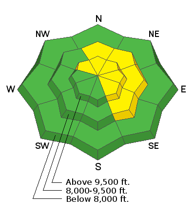
The overall avalanche danger is LOW to MODERATE today. Watch for areas of wind drifted snow along the more east facing steep slopes especially just below the ridgelines. Anticipate more dangerous conditions on Sunday as the storm moves through.
Low
Moderate
Considerable
High
Extreme
Learn how to read the forecast here
Weather and Snow
The last 48 hours: The Skyline picked up 6 inches of dense snow over the last couple of days. Some areas received a bit less, some a bit more. Temperatures have been mild and were in the upper 20s to around freezing overnight. The wind has been from the southwest and moderate in speed with some stronger speeds along the exposed ridges.
Today: We'll see mostly cloudy skies with the chance for light snowfall this morning and more pronounced snowfall this afternoon as the next storm moves in. I'm expecting around 6 inches of snow by Sunday morning. Temperatures will remain in the upper 20s and westerly wind will start to increase, more so late in the day.
Extended: The broad trough which is producing this storm will linger through Monday with periods of snow. We should see another 6 inches or so on Sunday into Monday bringing totals to around a foot or so, maybe a bit more if we're lucky. Another storm moves through Wednesday then another next weekend.
Ad
Avalanche Problem #1
Wind Drifted Snow
Type
Location
Likelihood
Size
Description
The main concern today is fresh wind drifted snow. You may find drifts on the more east facing slopes that are sensitive if provoked with skis or a machine. These probably won't produce huge avalanches but it's something to keep in mind. Even small wind drifted slopes can be dangerous.
Additional Information
This forecast is from the U.S. Forest Service, which is solely responsible for its content. This forecast describes general avalanche conditions and local variations always occur.