Forecast for the Skyline Area Mountains

Brett Kobernik
Issued by Brett Kobernik on
Tuesday morning, March 17, 2026

There has been no significant change in avalanche conditions over the last few days.

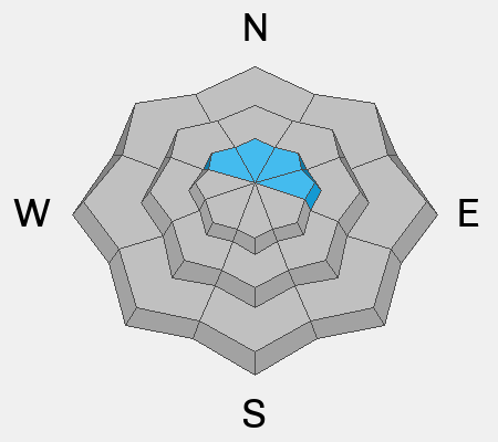
A "pockety" MODERATE avalanche danger remains above 9500' on steep slopes that face northwest, north, northeast and east.

The chance of triggering an avalanche that breaks into the old January facets is getting pretty slim. But faceted snow still remains in the snowpack, and I don't like that.

Low
Moderate
Considerable
High
Extreme
Learn how to read the forecast here
Special Announcements

Each spring, we ask for your continued financial support to fund our forecasting and education programs. Our Spring Campaign and Spring Auction are now live and we hope you will consider supporting our mission. DETAILS HERE

Weather and Snow

General Conditions: Temperatures were in the mid-30s on Monday and dropped into the mid-20s overnight. Wind from the northwest was fairly breezy on Monday. It's been gradually slowing since then. The snow surface should be frozen again this morning with stout crusts.

Mountain Weather: The "Super Ridge" is building in today through the rest of the week. We'll see mostly clear skies today with temperatures into the upper 40s. Wind will be light to moderate in speed from the northwest. It seems like it wants to be a bit breezy still. Temperatures only get warmer through the week. No storms are in sight through the end of the month.
Avalanche Problem #1
Persistent Weak Layer
Type
Location
Likelihood
Size
Description

Overall, there is not much avalanche danger out there right now. Although it is becoming less and less likely that a person will trigger an avalanche breaking into old, weak, faceted snow from January, it is still worth mentioning. On the rare chance that you find trouble out there today, it would be on a very steep slope in the highest elevation northerly facing terrain.

General Announcements
This forecast is from the U.S.D.A. Forest Service, which is solely responsible for its content. This forecast describes general avalanche conditions and local variations always occur.