Forecast for the Skyline Area Mountains

Brett Kobernik
Issued by Brett Kobernik on
Wednesday morning, March 18, 2026

Very warm temperatures are moving in through the rest of the week. This may affect avalanche conditions.

As things continue to warm through the day today, the avalanche danger will rise to MODERATE above 9500' on slopes that face northwest, north, northeast and east.

Triggering a wet slab avalanche is possible in the described terrain. These conditions are highly unpredictable. To stay safe, it is best to avoid the steep upper elevation northerly facing terrain during this heat spell.
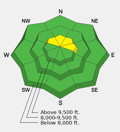
Low
Moderate
Considerable
High
Extreme
Learn how to read the forecast here
Special Announcements

Each spring, we ask for your continued financial support to fund our forecasting and education programs. Our Spring Campaign and Spring Auction are now live and we hope you will consider supporting our mission. DETAILS HERE

Weather and Snow

General Conditions: Temperatures were well into the mid 40s on Tuesday and only dropped into the mid 30s overnight. The wind has finally slowed. The snow surface has been freezing overnight and getting wet during the day. It may be frozen again this morning but this trend won't last with the very warm temperatures coming. The already very shallow snowpack is shrinking and this week is going to be the nail in the coffin.

Mountain Weather: The "Super Ridge" has moved in and will have a stranglehold on our weather for the foreseeable future. Temperatures will get into the 50s in the high country today. Wind from the west will stay fairly light. Warm weather continues through Saturday with daytime highs well into the 60s. Things cool slightly on Sunday but still stay warm. There are literally no storms in sight.
Avalanche Problem #1
Persistent Weak Layer
Type
Location
Likelihood
Size
Description

Our focus on the old January facets buried in the snowpack shifts with the upcoming heat wave. It may get warm enough to turn the cold dry facets into wet grains. If this happens, the snowpack could become unstable. Human-triggered wet slab avalanches are possible. We could see natural wet slab avalanches later in the week during the warmest temperatures.

This situation is very hard to predict. The biggest clue is recent natural avalanches. If you see any, this is a major red flag and you should avoid steep slopes. If you find yourself punching deep into sloppy wet snow, this is also a hint that the snow is becoming unstable. If you are going to get onto steep slopes, it is best to do it early in the day and avoid the steep terrain in the afternoon.

General Announcements
This forecast is from the U.S.D.A. Forest Service, which is solely responsible for its content. This forecast describes general avalanche conditions and local variations always occur.