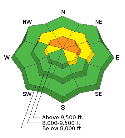
The persistent weak layer of sugary faceted snow is still present and is still a major concern. This is actually your only concern out there today. If you avoid steep slopes above 9500' that face northwest, north, northeast and east, you will stay safe.
When will this layer stabilize? This is unknown. What we do know is that these types of layers are slow to stabilize and gain strength. They often produce avalanches long after you might think they will. Here's what I am looking for when I go out and analyze this layer for signs of stabilization:
- An increase in the hardness of the sugary layer. This has happened to a certain extent but not even close to the point where it needs to be.
- The slab on top of the sugary layer to increase in strength. This has also happened somewhat but not enough yet. It would be nice if we could get a few more big storms to help this out. More weight also helps compress the sugary layer. One thing we have going for us is the warmer springtime temperatures. This will help in strengthening both the slab and the underlying sugar faster than it would happen in mid winter when temperatures remain cold.
- Snowpit test results can not show propagation, which they all do right now. That means that when doing snowpit tests, if they are producing a smooth planer break, avalanches breaking into that layer are still possible. I have had test results that I would consider stubborn yet they still broke clean. There were also avalanches triggered that day.
- I'd like to see a large and windy snowstorm with no avalanche activity. Like two feet with wind. If the snowpack can take a good "thump" like that without producing avalanches and the rest of the things I mentioned have happened, we can call the snowpack stable. Until then, we watch.


